Elara
GRUPE NAYAN DEVELOPERS · Rangareddy · RERA P02400010097
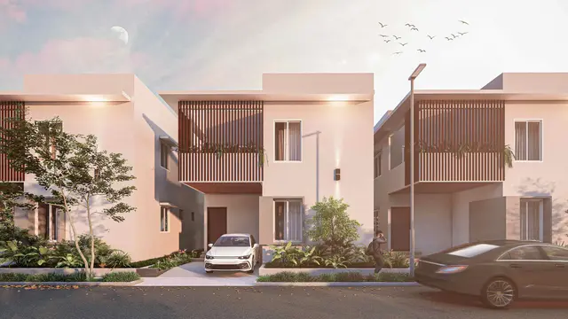
ELARA is a residential gated community with housing in Kongara Khurdu (A), Maheshwaram, Ranga Reddy. It is being developed by the registered promoter GRUPE NAYAN DEVELOPERS on a site of 19,433.96 sq.m., with 64 residential buildings, each Ground Floor + 2 Floors, and one amenities building with Stilt + 3 Floors. The RERA land-details filing states 65 total building units and 65 proposed building units; filed unit descriptions include “GROUND FLOOR DUPLEX,” “FIRST FLOOR DUPLEX” and “SECOND FLOOR DUPLEX.” The project is registered under TG-RERA registration P02400010097, with a proposed completion date of 22/12/2030.
01What we found
Read from TG-RERA filings, approvals, land and registration records and court records. A court case is counted only when the court record states this project's survey number with its village, or names the project.
02Check before you pay
11 items to check before you pay, 5 high - from the title chain, court records and approvals, each with what to ask the builder or your advocate. An item may not be a problem with the project: records can be incomplete.
1. Project at a glance
Project identity
| Field | Project record |
|---|---|
| Registered name | ELARA RERA record |
| Project type | Residential; the filed project is a gated community with housing and the approval documents describe villas. RERA record |
| Phase / registered portion | A phase designation is not disclosed. TG-RERA registration is P02400010097. RERA record |
| Registration validity | 22 August 2025 to 22 August 2030 (five years), unless extended by the Authority. This is registration validity, not the project’s declared completion date. |
| Registered promoter | GRUPE NAYAN DEVELOPERS. RERA record |
| RERA status | The project is registered; the certificate requires quarterly updates and other promoter obligations. The supplied record does not establish construction progress or completion. |
Land and geographic identity
| Field | Project record |
|---|---|
| Locality | Kongara Khurdu (A) / Kongara Khurdu; the RERA certificate identifies Kongarakurdu. RERA record |
| Revenue village | KONGARA KHURD - A in the layout-plan extraction; Konga in the permit-order extraction; Kongarakurdu in the RERA certificate and project identity. |
| Mandal / district / PIN | Maheshwaram / Ranga Reddy / 501510. RERA record |
| Project survey identity | OLD SURVEY NOs. 276/PART, 277/PART, 278/PART; NEW SURVEY NOs. 417/PART, 418/PART, 422/PART. The permit extracts also show 276/Part, 277/Part, 278/Part, 417/Part, 418/Part and 422/Part. RERA record |
| Registered site extent | 19,433.96 sq.m. RERA record |
| Net / total area | The filed land details state 19,433.96 sq.m. total and net area. The permit order also records 0 road-affected area and 0 NALA-affected area. RERA filing |
| Boundaries | East: HMDA layout named Wonder City; West: land of Krishna Reddy; North: owners and others’ land; South: land of others and owners’ land in Sy. No. 278 part. RERA filing |
Development identity
| Field | Project record |
|---|---|
| Sanctioning authority | Hyderabad Metropolitan Development Authority (HMDA); the permit-order extract also identifies Thukkuguda Municipality as delegated local body. Approvals record |
| Principal permit / approval number | 001289/HMDA/00339/SWDL/SHZ/2025, dated 19/05/2025 in the permit-order extraction. Approvals record |
| Approved built-up area | 17,428.84 sq.m. in the permit-order extraction and RERA filing. RERA filing |
| Buildings / configuration | The permit-order extraction lists 64 residential buildings, each Ground Floor + 2 Floors, and one amenities building with Stilt + 3 Floors. It also contains a summary entry “No. of Buildings 1”; the detailed building schedule identifies the residential buildings individually. |
| Height information | The permit extraction lists residential-building heights of 9.45 m and amenities-building height of 9.0 m; the layout-plan extraction also lists 11.93 m for Plot 43. |
| Parking | The layout-plan extraction states proposed parking area 877.91 sq.m. and visitor parking area 274.46 sq.m. The permit conditions refer to parking approved in the plan; a total bay count is not established in the supplied data. |
| Unit counts | The RERA land-details filing states 65 total building units and 65 proposed building units. The permit-order extraction states 64 dwelling units; the layout plan extraction contains “64 dwelling units” and also a separate “num_plots: 65” field. RERA filing |
Offering and status
| Field | Project record |
|---|---|
| RERA-filed unit descriptions | The filing labels units by floor, including “GROUND FLOOR DUPLEX,” “FIRST FLOOR DUPLEX” and “SECOND FLOOR DUPLEX”; it does not provide a clear, conventional villa configuration schedule. RERA unit table |
| RERA-filed saleable area | Filed unit rows range from 70.41 sq.m. to 246.85 sq.m.; see the configuration table below. RERA unit details RERA unit table |
| Bookings / availability | Portal-derived filing data records 36 booked and 159 available entries across 195 floor-labelled rows. The portal extract has no as-of date, and these rows are not a reliable count of distinct homes. RERA unit table RERA unit details |
| Construction stage | No independently verified site-progress evidence or quantified RERA construction-progress update is supplied. Document index |
| Completion date | Promoter Form B undertakes completion by 22/08/2030. The RERA header separately records a proposed completion date of 22/12/2030. RERA filing |
| Occupancy / completion certificate | No occupancy or completion certificate is supplied. The permit conditions state that an occupancy certificate is required before occupation. |
2. The project story
ELARA is registered as a residential project in Kongara Khurdu (A), Maheshwaram mandal, Ranga Reddy district. Its filed and approval descriptions present a gated residential community with housing, organized as individual low-rise homes rather than a conventional apartment tower scheme. RERA record
The permit-order schedule identifies 64 residential buildings, each described as Ground Floor + 2 Floors, alongside a separate amenities building. The approved layout-plan extraction records a site of 19,433.96 sq.m., internal roads, organized open space, utility land and an amenities plot. The permit order describes infrastructure and development works including roads, drainage, water-supply infrastructure, street lighting and park development. These are approval requirements or planned provisions; the supplied evidence does not verify their completion at the site.
The project is registered under TG-RERA. The RERA certificate remains valid to 22 August 2030 unless extended; this should not be read as the construction deadline. The promoter’s Form B states a completion undertaking of 22 August 2030, while the RERA project information field lists 22 December 2030. The evidence provided does not establish the current construction stage, completion of any particular villa or facility, or issue of an occupancy certificate. RERA filing
3. Master plan, architecture & building design
The approval records describe a gated layout with low-rise residential buildings. The detailed permit schedule names residential buildings 1.0 through 64.0, each Ground Floor + 2 Floors, and an amenities building with 1 Stilt + 3 Floors. The approval extract also records an approved built-up area of 17,428.84 sq.m. and amenities area of 723.21 sq.m.
The layout-plan extraction allocates the 19,433.96 sq.m. total layout area as follows:
| Layout component | Area | Share shown in plan |
|---|---|---|
| Plotted area | 10,106.28 sq.m. | 52.00% |
| Amenities plot area | 676.82 sq.m. | 3.48% |
| Roads | 6,145.50 sq.m. | 31.62% |
| Organized open space | 2,267.70 sq.m. | 11.67% |
| Utility area | 237.64 sq.m. | 1.22% |
| Total layout area | 19,433.96 sq.m. | 100% |
The drawing-derived layout record identifies 64 plots in its plot schedule. The approval extraction separately records a Plot 43 building height of 11.93 m and identifies Plot 65 as “Mortgage amenities - 65.” Layout record
The approved records describe road widths including 30.0 m, 12.2 m, 12.19 m, 9.14 m and 18 m; the permit conditions call for road formation, storm-water drainage, underground utility ducting, footpaths, street lighting and avenue planting. These describe sanctioned or required works, not verified as-built conditions.
The 17,428.84 sq.m. figure is the approved built-up area in the permit extraction. No supplied record provides a separate FSI-counted area, carpet-area total for the development, or completed/as-built area.
4. Homes, configurations & floor plans
The RERA unit table uses floor labels rather than a clear villa-configuration schedule. Its 195 entries include repeated floor labels and are not presented here as 195 distinct homes. The supplied drawing measurement identifies 1BHK floor-plan designs, but that configuration is not matched to a RERA-filed configuration; software measurements therefore describe drawing geometry only and should be checked against the approved drawing. RERA unit details RERA unit table Floor plans
| Configuration | Units | Booked | Available | RERA saleable area | Measured carpet area | Loading (if supplied) |
|---|---|---|---|---|---|---|
| RERA filing: “GROUND FLOOR DUPLEX” | 63 | 12 | 51 | 88.11 sq.m. | Not supplied for a matched RERA configuration | Not supplied |
| RERA filing: “FIRST FLOOR DUPLEX” | 64 | 12 | 52 | 102.34 sq.m. | Not supplied for a matched RERA configuration | Not supplied |
| RERA filing: “SECOND FLOOR DUPLEX” | 64 | 12 | 52 | 70.41 sq.m. | Not supplied for a matched RERA configuration | Not supplied |
| RERA filing: “GROUND FLOOR DUPELX” | 1 | 0 | 1 | 108.41 sq.m. | Not supplied for a matched RERA configuration | Not supplied |
| RERA filing: “FIRST FLOOR” | 1 | 0 | 1 | 228.62 sq.m. | Not supplied for a matched RERA configuration | Not supplied |
| RERA filing: “SECOND FLOOR” | 1 | 0 | 1 | 238.18 sq.m. | Not supplied for a matched RERA configuration | Not supplied |
| RERA filing: “GROUND FLOOR” | 1 | 0 | 1 | 246.85 sq.m. | Not supplied for a matched RERA configuration | Not supplied |
| Drawing measurement: “1BHK” (not matched to a RERA configuration) | Not established in RERA filing | — | — | Not filed as this configuration | 45.8–97.0 sq.m.; median 68.4 sq.m. (software-measured) | Not supplied |
The drawing measurement covers 14 1BHK designs and marks 14 measurements as needing review. For one measured ground-floor plan, flat 106, the drawing labels a hall, kitchen, bedroom, toilet, puja space and two balconies; the balconies are excluded from the software-measured carpet area. Carpet area is not interchangeable with RERA saleable area, which includes a share of common areas. Floor plans RERA unit details
The portal-derived booked and available figures are indicative only: the extract provides no as-of date and its floor-label rows do not establish the number of distinct villas currently offered. RERA unit table RERA unit details
5. Parking & vehicle circulation
The layout-plan extraction records 877.91 sq.m. of proposed parking area and 274.46 sq.m. of proposed visitor parking area. It does not provide a total number of parking spaces, a resident/visitor bay schedule, accessible-space count, EV-charger count or unit-specific parking allocation.
The permit conditions state that cellar and stilt parking shown in the plan must be used exclusively for vehicle parking and not partitioned or converted to another use. They also require EV charging infrastructure in parking places. These are approval conditions; the supplied evidence does not establish installation, completion or an individual purchaser’s exclusive parking rights.
6. Amenities, recreation & open spaces
The layout plan and permit records identify common areas and facilities as planned or required provisions. No supplied evidence verifies that any facility is complete or operational.
| Description / size | Amenities plot area 676.82 sq.m. in the layout plan; permit extraction records amenities area 723.21 sq.m.; Stilt + 3 Floors |
|---|---|
| Declared progress / verified status | Approved/planned; completion not established |
| Description / size | 2,267.70 sq.m.; identified as “Tot-lot - 1” in the layout-plan parameters |
|---|---|
| Evidence source | Layout record |
| Declared progress / verified status | Plan/permit provision; completion not established |
| Description / size | Park development and avenue plantation appear among required layout works |
|---|---|
| Declared progress / verified status | Required/planned; completion not established |
| Description / size | Green strip and perimeter greenery are identified in the layout plan and permit conditions |
|---|---|
| Declared progress / verified status | Required/planned; completion not established |
| Description / size | “Community Buildings” is listed in the RERA amenities record |
|---|---|
| Evidence source | RERA amenities |
| Declared progress / verified status | Listed as available in the filing; progress is recorded as 0% |
| Description / size | Internal roads and footpaths listed in the RERA amenities record; permit conditions also require road and footpath works |
|---|---|
| Evidence source | RERA amenities |
| Declared progress / verified status | Listed in filing; progress is recorded as 0% |
| Description / size | RERA amenities record lists aggregate recreational open space but provides no separate area in that entry |
|---|---|
| Evidence source | RERA amenities |
| Declared progress / verified status | Progress recorded as 0% |
The vendor-provided list mentions additional facilities such as a clubhouse, swimming pool, gymnasium, banquet hall, indoor games room, library and jogging track. These are vendor/marketing claims, not established here as RERA-filed, sanctioned or delivered facilities. Promoter website
7. Utilities, building services & safety
The RERA amenities record lists water supply, sewerage, storm-water drains, sewage and sullage treatment/disposal, solid-waste management, rainwater harvesting, street lighting and an electrical meter room/sub-station/receiving station. The same record shows 0% progress for listed amenities; it does not supply commissioning evidence or capacities. RERA amenities
The permit order requires or describes internal water-supply lines, an overhead tank and sumps; underground drainage and a common septic tank/STP; storm-water drains; a transformer and street lighting; garbage handling and bio-composting; and rainwater-harvesting works. The permit extraction records 0 rainwater-harvesting pits in a sanctioned-parameters field, while the conditions and development-works descriptions call for rainwater-harvesting pits. The supplied evidence does not establish what has been installed or completed.
The permit conditions also require fire-fighting installations and an occupancy Fire NOC before an occupancy certificate, along with qualified technical supervision of services. No project-specific Fire NOC, occupancy certificate, water-source approval, utility connection confirmation, lift schedule, security-system specification or accessibility plan is supplied.
8. Location, access & connectivity
The registered project location is Kongarakurdu, Maheshwaram mandal, Ranga Reddy district, Telangana, PIN 501510. The permit records identify the revenue location as Konga / Kongara Khurd - A. RERA record
The supplied location record gives an approximate distance of 10.6 km to the nearest sampled Outer Ring Road interchange. A vendor listing separately names nearby schools, a bus depot and bus stop, a hospital, a community health centre and Electronic Hardware Park, with stated distances; these are vendor-provided details rather than distances independently established by the RERA filing. Location record Promoter website
9. Developer & development status
The registered legal promoter is GRUPE NAYAN DEVELOPERS, identified in the filing as a partnership. Its GSTIN is 36ABAFG3093J1ZB. The supplied RERA certificate identifies VATTI JEEVAN REDDY as the promoter’s representative. The RERA filing lists the promoter address as Plot No. 232, 4th Floor, Nagarjuna Colony, Kongarakurdu, Kongara Khurdu (A), Maheshwaram, Ranga Reddy, Telangana, PIN 501510. Corporate record Parties record
The RERA registration certificate records validity from 22/08/2025 to 22/08/2030 and requires quarterly updates. The promoter’s Form B states a completion undertaking of 22/08/2030. The RERA project-information record separately lists 22/12/2030 as the proposed completion date. No construction-progress percentage or independently verified site status is supplied. RERA filing
10. Approvals, official records & documents
| Identifier / date | P02400010097; valid 22/08/2025–22/08/2030 |
|---|---|
| Scope and evidence | Form C certificate for ELARA and GRUPE NAYAN DEVELOPERS. |
| Identifier / date | 001289/HMDA/00339/SWDL/SHZ/2025; permit extraction records 19/05/2025 |
|---|---|
| Scope and evidence | Gated-community housing layout covering 19,433.96 sq.m. and the stated survey lands. |
| Identifier / date | Drawing/document 603699; approval drawing stamp read as 22/08/2025 |
|---|---|
| Scope and evidence | Plan and layout-derived information, including layout area, land-use allocation, building labels and road widths. The supplied HMDA public layout lookup is unavailable; the drawing itself is the available record. HMDA |
| Identifier / date | 0395/HMDA/SWDL/2025; extraction records 22/08/2025 |
|---|---|
| Scope and evidence | Permit-order extraction identifying 64 dwelling units, residential buildings and amenities building. |
| Identifier / date | 13633/2025, dated 04/08/2025 |
|---|---|
| Scope and evidence | Mortgage of Villa Nos. 61, 62, 63 and 64 in favour of the Metropolitan Commissioner, HMDA; described in the permit records. |
| Identifier / date | August 2025 |
|---|---|
| Scope and evidence | Identifies the project land and landowners, refers to Development Agreement-cum-GPA Nos. 5626/2025 and 7909/2025, and records the promoter’s declarations and completion undertaking. |
| Identifier / date | Not supplied as an issued project-wide occupancy or completion certificate |
|---|---|
| Scope and evidence | The permit conditions require an occupancy certificate before occupation; the supplied documents do not establish that one has been issued. |
The approval records specify required development works and conditions, including roads, drainage, water supply, waste arrangements, open spaces and safety provisions. This overview records those as permit requirements or planned provisions where stated; it does not treat them as evidence of completed works.
1. Project at a glance
Project identity
Registered name: ELARA
Project type: Residential; the filed project is a gated community with housing and the approval documents describe villas.
Phase / registered portion: A phase designation is not disclosed. TG-RERA registration is P02400010097.
Registration validity: 22 August 2025 to 22 August 2030 (five years), unless extended by the Authority. This is registration validity, not the project’s declared completion date.
Registered promoter: GRUPE NAYAN DEVELOPERS.
RERA status: The project is registered; the certificate requires quarterly updates and other promoter obligations. The supplied record does not establish construction progress or completion.
Land and geographic identity
Locality: Kongara Khurdu (A) / Kongara Khurdu; the RERA certificate identifies Kongarakurdu.
Revenue village: KONGARA KHURD - A in the layout-plan extraction; Konga in the permit-order extraction; Kongarakurdu in the RERA certificate and project identity.
Mandal / district / PIN: Maheshwaram / Ranga Reddy / 501510.
Project survey identity: OLD SURVEY NOs. 276/PART, 277/PART, 278/PART; NEW SURVEY NOs. 417/PART, 418/PART, 422/PART. The permit extracts also show 276/Part, 277/Part, 278/Part, 417/Part, 418/Part and 422/Part.
Registered site extent: 19,433.96 sq.m.
Net / total area: The filed land details state 19,433.96 sq.m. total and net area. The permit order also records 0 road-affected area and 0 NALA-affected area.
Boundaries: East: HMDA layout named Wonder City; West: land of Krishna Reddy; North: owners and others’ land; South: land of others and owners’ land in Sy. No. 278 part.
Development identity
Sanctioning authority: Hyderabad Metropolitan Development Authority (HMDA); the permit-order extract also identifies Thukkuguda Municipality as delegated local body.
Principal permit / approval number: 001289/HMDA/00339/SWDL/SHZ/2025, dated 19/05/2025 in the permit-order extraction.
Approved built-up area: 17,428.84 sq.m. in the permit-order extraction and RERA filing.
Buildings / configuration: The permit-order extraction lists 64 residential buildings, each Ground Floor + 2 Floors, and one amenities building with Stilt + 3 Floors. It also contains a summary entry “No. of Buildings 1”; the detailed building schedule identifies the residential buildings individually.
Height information: The permit extraction lists residential-building heights of 9.45 m and amenities-building height of 9.0 m; the layout-plan extraction also lists 11.93 m for Plot 43.
Parking: The layout-plan extraction states proposed parking area 877.91 sq.m. and visitor parking area 274.46 sq.m. The permit conditions refer to parking approved in the plan; a total bay count is not established in the supplied data.
Unit counts: The RERA land-details filing states 65 total building units and 65 proposed building units. The permit-order extraction states 64 dwelling units; the layout plan extraction contains “64 dwelling units” and also a separate “num_plots: 65” field.
Offering and status
RERA-filed unit descriptions: The filing labels units by floor, including “GROUND FLOOR DUPLEX,” “FIRST FLOOR DUPLEX” and “SECOND FLOOR DUPLEX”; it does not provide a clear, conventional villa configuration schedule.
RERA-filed saleable area: Filed unit rows range from 70.41 sq.m. to 246.85 sq.m.; see the configuration table below.
Bookings / availability: Portal-derived filing data records 36 booked and 159 available entries across 195 floor-labelled rows. The portal extract has no as-of date, and these rows are not a reliable count of distinct homes.
Construction stage: No independently verified site-progress evidence or quantified RERA construction-progress update is supplied.
Completion date: Promoter Form B undertakes completion by 22/08/2030. The RERA header separately records a proposed completion date of 22/12/2030.
Occupancy / completion certificate: No occupancy or completion certificate is supplied. The permit conditions state that an occupancy certificate is required before occupation.
2. The project story
ELARA is registered as a residential project in Kongara Khurdu (A), Maheshwaram mandal, Ranga Reddy district. Its filed and approval descriptions present a gated residential community with housing, organized as individual low-rise homes rather than a conventional apartment tower scheme.
The permit-order schedule identifies 64 residential buildings, each described as Ground Floor + 2 Floors, alongside a separate amenities building. The approved layout-plan extraction records a site of 19,433.96 sq.m., internal roads, organized open space, utility land and an amenities plot. The permit order describes infrastructure and development works including roads, drainage, water-supply infrastructure, street lighting and park development. These are approval requirements or planned provisions; the supplied evidence does not verify their completion at the site.
The project is registered under TG-RERA. The RERA certificate remains valid to 22 August 2030 unless extended; this should not be read as the construction deadline. The promoter’s Form B states a completion undertaking of 22 August 2030, while the RERA project information field lists 22 December 2030. The evidence provided does not establish the current construction stage, completion of any particular villa or facility, or issue of an occupancy certificate.
3. Master plan, architecture & building design
The approval records describe a gated layout with low-rise residential buildings. The detailed permit schedule names residential buildings 1.0 through 64.0, each Ground Floor + 2 Floors, and an amenities building with 1 Stilt + 3 Floors. The approval extract also records an approved built-up area of 17,428.84 sq.m. and amenities area of 723.21 sq.m.
The layout-plan extraction allocates the 19,433.96 sq.m. total layout area as follows:
| Layout component | Area | Share shown in plan |
|---|---|---|
| Plotted area | 10,106.28 sq.m. | 52.00% |
| Amenities plot area | 676.82 sq.m. | 3.48% |
| Roads | 6,145.50 sq.m. | 31.62% |
| Organized open space | 2,267.70 sq.m. | 11.67% |
| Utility area | 237.64 sq.m. | 1.22% |
| Total layout area | 19,433.96 sq.m. | 100% |
The drawing-derived layout record identifies 64 plots in its plot schedule. The approval extraction separately records a Plot 43 building height of 11.93 m and identifies Plot 65 as “Mortgage amenities - 65.”
The approved records describe road widths including 30.0 m, 12.2 m, 12.19 m, 9.14 m and 18 m; the permit conditions call for road formation, storm-water drainage, underground utility ducting, footpaths, street lighting and avenue planting. These describe sanctioned or required works, not verified as-built conditions.
The 17,428.84 sq.m. figure is the approved built-up area in the permit extraction. No supplied record provides a separate FSI-counted area, carpet-area total for the development, or completed/as-built area.
4. Homes, configurations & floor plans
The RERA unit table uses floor labels rather than a clear villa-configuration schedule. Its 195 entries include repeated floor labels and are not presented here as 195 distinct homes. The supplied drawing measurement identifies 1BHK floor-plan designs, but that configuration is not matched to a RERA-filed configuration; software measurements therefore describe drawing geometry only and should be checked against the approved drawing.
| Configuration | Units | Booked | Available | RERA saleable area | Measured carpet area | Loading (if supplied) |
|---|---|---|---|---|---|---|
| RERA filing: “GROUND FLOOR DUPLEX” | 63 | 12 | 51 | 88.11 sq.m. | Not supplied for a matched RERA configuration | Not supplied |
| RERA filing: “FIRST FLOOR DUPLEX” | 64 | 12 | 52 | 102.34 sq.m. | Not supplied for a matched RERA configuration | Not supplied |
| RERA filing: “SECOND FLOOR DUPLEX” | 64 | 12 | 52 | 70.41 sq.m. | Not supplied for a matched RERA configuration | Not supplied |
| RERA filing: “GROUND FLOOR DUPELX” | 1 | 0 | 1 | 108.41 sq.m. | Not supplied for a matched RERA configuration | Not supplied |
| RERA filing: “FIRST FLOOR” | 1 | 0 | 1 | 228.62 sq.m. | Not supplied for a matched RERA configuration | Not supplied |
| RERA filing: “SECOND FLOOR” | 1 | 0 | 1 | 238.18 sq.m. | Not supplied for a matched RERA configuration | Not supplied |
| RERA filing: “GROUND FLOOR” | 1 | 0 | 1 | 246.85 sq.m. | Not supplied for a matched RERA configuration | Not supplied |
| Drawing measurement: “1BHK” (not matched to a RERA configuration) | Not established in RERA filing | — | — | Not filed as this configuration | 45.8–97.0 sq.m.; median 68.4 sq.m. (software-measured) | Not supplied |
The drawing measurement covers 14 1BHK designs and marks 14 measurements as needing review. For one measured ground-floor plan, flat 106, the drawing labels a hall, kitchen, bedroom, toilet, puja space and two balconies; the balconies are excluded from the software-measured carpet area. Carpet area is not interchangeable with RERA saleable area, which includes a share of common areas.
The portal-derived booked and available figures are indicative only: the extract provides no as-of date and its floor-label rows do not establish the number of distinct villas currently offered.
5. Parking & vehicle circulation
The layout-plan extraction records 877.91 sq.m. of proposed parking area and 274.46 sq.m. of proposed visitor parking area. It does not provide a total number of parking spaces, a resident/visitor bay schedule, accessible-space count, EV-charger count or unit-specific parking allocation.
The permit conditions state that cellar and stilt parking shown in the plan must be used exclusively for vehicle parking and not partitioned or converted to another use. They also require EV charging infrastructure in parking places. These are approval conditions; the supplied evidence does not establish installation, completion or an individual purchaser’s exclusive parking rights.
6. Amenities, recreation & open spaces
The layout plan and permit records identify common areas and facilities as planned or required provisions. No supplied evidence verifies that any facility is complete or operational.
| Facility | Description / size | Evidence source | Declared progress / verified status |
|---|---|---|---|
| Amenities building | Amenities plot area 676.82 sq.m. in the layout plan; permit extraction records amenities area 723.21 sq.m.; Stilt + 3 Floors | Approved/planned; completion not established | |
| Organized open space / tot-lot | 2,267.70 sq.m.; identified as “Tot-lot - 1” in the layout-plan parameters | Plan/permit provision; completion not established | |
| Park development | Park development and avenue plantation appear among required layout works | Required/planned; completion not established | |
| Green strip | Green strip and perimeter greenery are identified in the layout plan and permit conditions | Required/planned; completion not established | |
| Community buildings | “Community Buildings” is listed in the RERA amenities record | Listed as available in the filing; progress is recorded as 0% | |
| Internal roads and footpaths | Internal roads and footpaths listed in the RERA amenities record; permit conditions also require road and footpath works | Listed in filing; progress is recorded as 0% | |
| Recreation / open-space aggregate | RERA amenities record lists aggregate recreational open space but provides no separate area in that entry | Progress recorded as 0% |
The vendor-provided list mentions additional facilities such as a clubhouse, swimming pool, gymnasium, banquet hall, indoor games room, library and jogging track. These are vendor/marketing claims, not established here as RERA-filed, sanctioned or delivered facilities.
7. Utilities, building services & safety
The RERA amenities record lists water supply, sewerage, storm-water drains, sewage and sullage treatment/disposal, solid-waste management, rainwater harvesting, street lighting and an electrical meter room/sub-station/receiving station. The same record shows 0% progress for listed amenities; it does not supply commissioning evidence or capacities.
The permit order requires or describes internal water-supply lines, an overhead tank and sumps; underground drainage and a common septic tank/STP; storm-water drains; a transformer and street lighting; garbage handling and bio-composting; and rainwater-harvesting works. The permit extraction records 0 rainwater-harvesting pits in a sanctioned-parameters field, while the conditions and development-works descriptions call for rainwater-harvesting pits. The supplied evidence does not establish what has been installed or completed.
The permit conditions also require fire-fighting installations and an occupancy Fire NOC before an occupancy certificate, along with qualified technical supervision of services. No project-specific Fire NOC, occupancy certificate, water-source approval, utility connection confirmation, lift schedule, security-system specification or accessibility plan is supplied.
8. Location, access & connectivity
The registered project location is Kongarakurdu, Maheshwaram mandal, Ranga Reddy district, Telangana, PIN 501510. The permit records identify the revenue location as Konga / Kongara Khurd - A.
The supplied location record gives an approximate distance of 10.6 km to the nearest sampled Outer Ring Road interchange. A vendor listing separately names nearby schools, a bus depot and bus stop, a hospital, a community health centre and Electronic Hardware Park, with stated distances; these are vendor-provided details rather than distances independently established by the RERA filing.
9. Developer & development status
The registered legal promoter is GRUPE NAYAN DEVELOPERS, identified in the filing as a partnership. Its GSTIN is 36ABAFG3093J1ZB. The supplied RERA certificate identifies VATTI JEEVAN REDDY as the promoter’s representative. The RERA filing lists the promoter address as Plot No. 232, 4th Floor, Nagarjuna Colony, Kongarakurdu, Kongara Khurdu (A), Maheshwaram, Ranga Reddy, Telangana, PIN 501510.
The RERA registration certificate records validity from 22/08/2025 to 22/08/2030 and requires quarterly updates. The promoter’s Form B states a completion undertaking of 22/08/2030. The RERA project-information record separately lists 22/12/2030 as the proposed completion date. No construction-progress percentage or independently verified site status is supplied.
10. Approvals, official records & documents
| Identifier / date | P02400010097; valid 22/08/2025–22/08/2030 |
|---|---|
| Scope and evidence | Form C certificate for ELARA and GRUPE NAYAN DEVELOPERS. |
| Identifier / date | 001289/HMDA/00339/SWDL/SHZ/2025; permit extraction records 19/05/2025 |
|---|---|
| Scope and evidence | Gated-community housing layout covering 19,433.96 sq.m. and the stated survey lands. |
| Identifier / date | Drawing/document 603699; approval drawing stamp read as 22/08/2025 |
|---|---|
| Scope and evidence | Plan and layout-derived information, including layout area, land-use allocation, building labels and road widths. The supplied HMDA public layout lookup is unavailable; the drawing itself is the available record. |
| Identifier / date | 0395/HMDA/SWDL/2025; extraction records 22/08/2025 |
|---|---|
| Scope and evidence | Permit-order extraction identifying 64 dwelling units, residential buildings and amenities building. |
| Identifier / date | 13633/2025, dated 04/08/2025 |
|---|---|
| Scope and evidence | Mortgage of Villa Nos. 61, 62, 63 and 64 in favour of the Metropolitan Commissioner, HMDA; described in the permit records. |
| Identifier / date | August 2025 |
|---|---|
| Scope and evidence | Identifies the project land and landowners, refers to Development Agreement-cum-GPA Nos. 5626/2025 and 7909/2025, and records the promoter’s declarations and completion undertaking. |
| Identifier / date | Not supplied as an issued project-wide occupancy or completion certificate |
|---|---|
| Scope and evidence | The permit conditions require an occupancy certificate before occupation; the supplied documents do not establish that one has been issued. |
The approval records specify required development works and conditions, including roads, drainage, water supply, waste arrangements, open spaces and safety provisions. This overview records those as permit requirements or planned provisions where stated; it does not treat them as evidence of completed works.
Frequently asked questions
Is ELARA registered with Telangana RERA?
Yes. ELARA is registered with the Telangana Real Estate Regulatory Authority as P02400010097; the registration status is New Project.
Who is the developer of ELARA?
The promoter named in the RERA registration is GRUPE NAYAN DEVELOPERS.
Where is ELARA located?
ELARA is in Kongara Khurdu (A), Kongarakurdu, Maheshwaram, Rangareddy, Telangana (501510).
When will ELARA be completed?
The promoter's proposed date of completion filed with RERA is 22/12/2030. This is the promoter's declaration, not a guarantee.
More projects in Kongarakurdu