Westlyn
S AND H LANDMARKS LLP · Sangareddy · RERA P01100010908
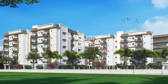
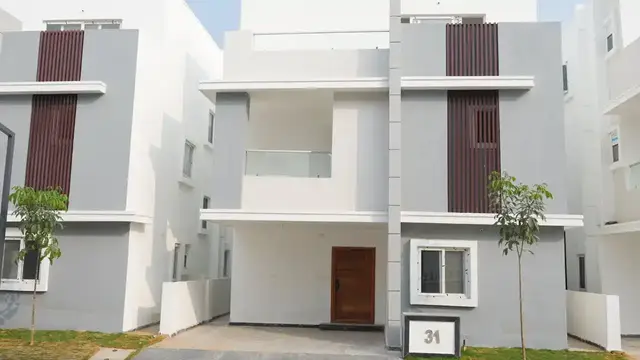
WESTLYN is a residential gated-community villa development in PATIGHANPUR, PATANCHERU Mandal, Sangareddy District, developed by S AND H LANDMARKS LLP. The site area is 42,841.52 sq.m, and the layout records 119 villas and one separate clubhouse; the villas are shown as Ground + 2 upper floors, with types A, B, C and D. The project is registered with TG-RERA under P01100010908, and the project header records a proposed completion date of 04/03/2029.
01What we found
Read from TG-RERA filings, approvals, land and registration records and court records. A court case is counted only when the court record states this project's survey number with its village, or names the project.
02Check before you pay
9 items to check before you pay, 5 high - from the title chain, court records and approvals, each with what to ask the builder or your advocate. An item may not be a problem with the project: records can be incomplete.
1. Project at a glance
Project identity
| Item | Record |
|---|---|
| Registered project name | WESTLYN RERA record |
| Project type | Residential gated-community villa development; the HMDA plan describes a proposed residential layout with housing under a gated community. RERA record |
| Phase / registered portion | No separate phase number is stated. The TG-RERA registration and HMDA layout records identify the project by the full survey schedule below. RERA record |
| TG-RERA registration | P01100010908 |
| Registration validity | 04/11/2025 to 04/11/2028; the certificate states a three-year validity period. This is registration validity, not the project completion deadline. |
| Registered promoter | S AND H LANDMARKS LLP; entity type: LLP. RERA record Corporate record |
| RERA status | Registered under section 5; the certificate records registration issued by TG-RERA. |
Land and geographic identity
| Item | Record |
|---|---|
| Locality / revenue village | PATIGHANPUR (also written Patighanpur Village in the filed layout documents). One revenue village is identified. RERA record RERA filing |
| Mandal | PATANCHERU RERA record RERA filing |
| District | Sangareddy RERA record RERA filing |
| PIN | 502300 RERA record |
| Project survey numbers | 318, 319/PART, 325/PART, 326, 327 and 329. These are the project-level survey descriptions in the RERA registration and HMDA layout records; no further project subdivisions are specified there. RERA record |
| Site area | 42,841.52 sq.m total site/layout area. RERA filing |
| Area figures recorded in the layout drawing | The drawing states 42,546.83 sq.m net layout area, 150.55 sq.m road-affected/road-widening area and 144.14 sq.m water-bodies area; it separately prints 42,496.96 sq.m net area of plot. These are drawing-stated categories. |
| RERA land-area fields | RERA filing records 42,841.52 sq.m total area, 294.69 sq.m affected area and 42,546.83 sq.m net area. RERA filing |
| Boundaries | East: Road; West: Vacant Land; North: Vacant Land; South: Vacant Land. RERA filing |
Development identity
| Item | Record |
|---|---|
| Sanctioning authority | Hyderabad Metropolitan Development Authority (HMDA). Approvals record |
| Principal layout approval / permit | 010005/LO/HMDA/2602/SKP/2024, dated 04 November 2025 in the draft layout letter. The layout drawing identifies file number TS/061836/2024. Approvals record |
| Approval status evidenced here | HMDA draft layout permission and layout drawing are on file; the documents refer to release of final layout after specified development and handover conditions. |
| Approved built-up area | The HMDA layout drawing states 37,792.24 sq.m proposed built-up area excluding parking and 39,963.08 sq.m including parking. Its printed table also lists Total BUA 39,963.07 and Net BUA 36,449.71; residential net BUA is 36,449.71 and commercial net BUA is 1,342.53. These are separately labelled drawing figures. |
| Building arrangement / count | The drawing records 119 villas and one separate clubhouse. It also contains building-type counts and a “Total NO OF BLDG 10 (TYPE A)” entry, among other type-count entries; the supplied extraction does not provide a single reconciled total building count. |
| Sanctioned villa configuration | The drawing labels villa types A, B, C and D and shows Ground + 2 upper floors for the residential villas. The separate clubhouse is shown as 3 floors. |
| Parking levels / approved parking count | No parking-space count or parking-level arrangement is established by the supplied extracts. The drawing’s built-up-area figures distinguish area including and excluding parking. |
| Unit counts | HMDA drawing: 119 villas and one separate clubhouse; RERA unit table: 358 rows/units recorded as floor labels, not as a reliable count of homes for sale. RERA unit details |
Offering and status
| Item | Record |
|---|---|
| RERA-filed unit labels and counts | “GROUND FLOOR” 119, “FIRST FLOOR” 118, “FIRST FLOR” 1 and “SECOND FLOOR” 120; the filing records 358 in total across these labels. These are floor-label rows, not a reliable count of saleable homes. RERA unit details RERA unit table |
| RERA-filed saleable-area range | 90.72–131.1 sq.m across the filed floor-label rows. RERA unit details RERA unit table |
| Booked / available | The portal-derived table records 0 booked and 358 available across the floor-label rows. The record has no as-of date, and those rows are not homes-on-sale configurations; do not treat the figures as a verified villa inventory. RERA unit details RERA unit table |
| Construction stage | No independently verified site-progress or construction-stage record is supplied. The registration and approval records describe proposed development. |
| Completion deadline | RERA Form B declares completion by 04th November 2028. The project header separately records a proposed completion date of 04/03/2029; the evidence does not establish a revised approval or extension that reconciles these dates. RERA record |
| Occupancy / completion certificate | No occupancy certificate or completion certificate is supplied for the project or any villa/phase. Document index Approvals record |
2. The project story
WESTLYN is recorded with TG-RERA as a residential project by S AND H LANDMARKS LLP at Patighanpur, Patancheru Mandal, Sangareddy District. The HMDA-filed plan describes a gated-community layout with housing across survey numbers 318, 319/PART, 325/PART, 326, 327 and 329. The drawing shows 119 proposed villas and a separate clubhouse; the villas are depicted as Ground + 2 upper floors. RERA record
The layout drawing allocates land to plots, roads, park/open space and utilities. Its figures include 25,843.83 sq.m plotted area, 11,406.23 sq.m roads, 5,101.65 sq.m organized open space/park and 195.10 sq.m utility area. These are figures printed in the plan, not a report of completed works. Layout record
The project is registered, and the file contains HMDA draft layout material, but the supplied evidence does not establish construction progress, completed villas, handover, or an occupancy certificate. The promoter’s completion undertaking is a declaration; it is not an independent progress verification.
3. Master plan, architecture & building design
The HMDA layout drawing presents a gated villa layout on a stated total area of 42,841.52 sq.m. It prints a net layout area of 42,546.83 sq.m and separately identifies 150.55 sq.m as road-affected/road-widening area and 144.14 sq.m as water-bodies area. The drawing’s land-use statement allocates 25,843.83 sq.m (60.74%) to plotted area, 11,406.23 sq.m (26.81%) to roads, 5,101.65 sq.m (11.99%) to organized open space/park and 195.10 sq.m (0.46%) to utilities. These are software-extracted figures from the filed drawing and should be checked against the original sheet. Layout record
The drawing identifies 119 villas and a separate clubhouse. It labels residential villa types A, B, C and D and shows villas as Ground + 2 upper floors. The clubhouse is shown as 3 floors. The extracted plan data does not establish a single reconciled total of building footprints, nor does it provide a complete phase schedule, villa-by-villa arrangement or verified building-height schedule.
The layout includes road widths labelled 4.50M WIDE DRIVE WAY, 10M WIDE ROAD, 9.14M WIDE ROAD, 12.0M WIDE ROAD, 12.00 MT WIDE EXISTING, 30.00 MT WIDE PROPOSED ROAD, PROPOSED 100'0" WIDE ROAD and EXISTING 40'0" WIDE ROAD. The supplied drawing extraction does not establish a complete circulation, entry/exit or pedestrian-separation plan.
The drawing separately states 37,792.24 sq.m proposed built-up area excluding parking, 39,963.08 sq.m including parking and 36,449.71 net BUA. Its table also identifies residential net BUA 36,449.71 and commercial net BUA 1,342.53. These labels are retained as supplied and are not treated as carpet area or saleable area.
4. Homes, configurations & floor plans
The RERA unit table is not organized into recognizable villa configurations: its labels are floor names, and the filing contains no reliable villa-type inventory. The registered plan, by contrast, identifies 119 proposed villas and a separate clubhouse. The following table preserves the RERA-filed floor-label data without presenting it as a count of homes available for purchase. RERA unit details
| Configuration | Units | Booked | Available | RERA saleable area | Measured carpet area | Loading (if supplied) |
|---|---|---|---|---|---|---|
| GROUND FLOOR (filed label) | 119 | 0 | 119 | 131.1 sq.m | Not established for a RERA-matched villa configuration | Not supplied |
| FIRST FLOOR (filed label) | 118 | 0 | 118 | 130.63 sq.m | Not established for a RERA-matched villa configuration | Not supplied |
| FIRST FLOR (filed label) | 1 | 0 | 1 | 127.35 sq.m | Not established for a RERA-matched villa configuration | Not supplied |
| SECOND FLOOR (filed label) | 120 | 0 | 120 | 90.72 sq.m | Not established for a RERA-matched villa configuration | Not supplied |
The approved layout drawing was also measured by software as containing nine designs labelled 1BHK, with carpet area 68.3–104.2 sq.m (median 84.6 sq.m, or 910 sq.ft median). This is a drawing-based measurement, is not matched to a RERA-filed configuration and requires review against the drawing; it should not be taken as a confirmed villa specification. One measured example labels a living/kitchen, bedroom, servant room, two toilets and utility; the utility is excluded from the measured carpet area. Floor plans RERA unit details
Carpet area is a drawing-based measurement here; RERA saleable area is the filed figure for the floor-label rows. They are different area concepts. No verified loading figure is supplied. Floor plans RERA unit details
5. Parking & vehicle circulation
The supplied records do not establish a count of car or two-wheeler spaces, visitor or accessible parking, parking levels, ramps, EV charging, or unit-specific parking allocation. The HMDA layout drawing’s built-up-area statement distinguishes area including parking (39,963.08 sq.m) from area excluding parking (37,792.24 sq.m), but does not provide a verified parking-space schedule in the available extraction.
6. Amenities, recreation & open spaces
The HMDA layout drawing identifies a separate clubhouse and lists clubhouse uses including reception, supermarket, party hall, café, gym, badminton court, indoor games, library, office and conference room. It also labels a swimming pool, tot-lot, park, green strip and water-bodies buffer. These are drawing-listed facilities; the supplied records do not establish construction or independent completion verification.
| Facility | Description / size | Evidence source | Declared progress / verified status |
|---|---|---|---|
| Clubhouse | Separate clubhouse; drawing shows 3 floors. The HMDA intimation records an amenities area of 2267.25 Sq.Mtrs, included in total plotted area. | Proposed/drawing-listed; no completion verification supplied. | |
| Clubhouse uses | Reception, supermarket, party hall, café, gym, badminton court, indoor games, library, office and conference room. | Drawing-listed; no progress or delivery evidence supplied. | |
| Swimming pool | Labelled in the layout drawing; no size supplied. | Drawing-listed; no completion verification supplied. | |
| Park / organized open space | 5,101.65 sq.m; drawing labels this as organized open space/park. | Allocated in drawing; no completed-condition verification supplied. | |
| Tot-lot / recreation | Tot-lot and green strip are labelled; no dimensions or capacities supplied. | Drawing-listed; no completion verification supplied. | |
| Utilities area | 195.10 sq.m in the drawing’s land-use statement. | Allocated in drawing; details are addressed below. |
The RERA portal amenity entries mark internal roads and footpaths, water supply, sewerage/STP, storm-water drains, park/tot-lot, street lighting, community buildings, sewage treatment/disposal, solid-waste management, rainwater harvesting and electrical meter/substation facilities as “YES”; the supplied records show 0% progress for the listed entries. This is a portal declaration, not evidence that these facilities are complete. RERA amenities
7. Utilities, building services & safety
The HMDA draft layout records proposed infrastructure including an STP, common septic tank, overhead tank, transformer, avenue plantation, park development, rainwater-harvesting pits, underground drainage lines, internal water-supply pipelines and street lights. The separate layout permission requires an underground storm-water drainage system and earmarked space for solid-waste disposal. These are approval-file statements or conditions; no capacities, commissioning records or independently verified completion evidence are supplied.
| Evidence in the file | Internal water-supply pipelines and overhead tank are listed in the HMDA-related extract; RERA amenity table marks water supply “YES.” |
|---|---|
| Status / limitation | Proposed/declared; source, storage capacity, treatment capacity and completion are not established. RERA amenities |
| Evidence in the file | STP, common septic tank, underground drainage lines and sewage treatment/disposal are listed; the layout permission requires underground storm-water drainage. |
|---|---|
| Status / limitation | Proposed/declared; capacity, reuse arrangements and commissioning are not supplied. RERA amenities |
| Evidence in the file | Transformer is listed; the RERA amenity table marks electrical meter room/substation/receiving station “YES.” |
|---|---|
| Status / limitation | Proposed/declared; sanctioned load, backup capacity and completion are not supplied. RERA amenities |
| Evidence in the file | No lift count, type or capacity is supplied for the villas or clubhouse. |
|---|---|
| Status / limitation | Not established in the available records. |
| Evidence in the file | RERA amenity table includes a fire-protection/fire-safety entry but provides no positive “available” value or progress detail in the supplied data. |
|---|---|
| Status / limitation | Systems, clearances and completion are not established. RERA amenities |
| Evidence in the file | Layout permission requires earmarked solid-waste disposal space; RERA amenity table marks solid-waste management “YES.” |
|---|---|
| Status / limitation | Proposed/declared; no waste-system capacity, CCTV or access-control details are supplied. RERA amenities |
| Evidence in the file | No accessible-route, ramp or accessible-parking details are supplied. |
|---|---|
| Status / limitation | Not established in the available records. |
8. Location, access & connectivity
The registered location is PATIGHANPUR, Patancheru Mandal, Sangareddy District, PIN 502300. The layout drawing identifies the project as situated at Patighanpur Village, Patancheru Mandal, Sangareddy District. RERA record
The layout drawing labels internal and adjoining roads, including existing 40'0" and proposed 100'0" roads, as well as roads of 4.50M, 9.14M, 10M, 12.0M, 12.00 MT and 30.00 MT widths. These are drawing labels, not a statement of present road completion or access condition.
The location dataset records the nearest sampled Outer Ring Road interchange at approximately 6.3 km. No travel time or public-transport details are supplied. Location record
9. Developer & development status
The registered legal promoter is S AND H LANDMARKS LLP, an LLP, with GSTIN 36AEZFS1533H1ZK. The RERA registration certificate lists the promoter office as Village: Madhapur, Mandal: Serilingampally, District: Ranga Reddy, Pin: 500081; the project filing separately gives a promoter address at Sri Sri Dham, Jubilee Enclave Layout, Patighanpur, Patancheru, Sangareddy, PIN 502300. Corporate record Parties record
The project file identifies KRISHNAM VENKATA MADHU KIRAN as an authorized signatory. The RERA registration records the promoter’s undertaking to complete by 04th November 2028; the project header separately shows proposed completion 04/03/2029. No extension order or independent construction-progress evidence is supplied here. Parties record RERA record
The RERA-filed landowner/developer affidavit states that a supplementary agreement formalizing final villa sharing and related entitlements had not yet been executed and registered when the affidavit was made; it describes the attached allocation as tentative and undertakes to submit the registered agreement within the stated timeframe.
10. Approvals, official records & documents
| Identifier / date | P01100010908; validity 04/11/2025–04/11/2028 |
|---|---|
| What the supplied record establishes | FORM C registration for WESTLYN under section 5; includes conditions concerning agreement for sale, conveyance, separate-account deposit and quarterly updates. |
| Identifier / date | 010005/LO/HMDA/2602/SKP/2024; 04 November 2025 |
|---|---|
| What the supplied record establishes | Draft layout permission for gated-community housing at Patighanpur; records a 42,841.52 sq.m site and 120 plots/villas and includes development and handover conditions. |
| Identifier / date | File TS/061836/2024; LTP licence CA/2009/46164 |
|---|---|
| What the supplied record establishes | Drawing for the proposed residential gated-community layout, identifying survey numbers, proposed villas, clubhouse, land-use allocations and road labels. |
| Identifier / date | File 010005/LO/HMDA/2602/SKP/2024; 12.05.2026 |
|---|---|
| What the supplied record establishes | States that the amenities area is 2267.25 Sq.Mtrs and is included in the total plotted area; identifies 119 villas and one separate clubhouse. |
| Identifier / date | No project commencement certificate by villa/phase, occupancy certificate or completion certificate supplied in the reviewed material. |
|---|---|
| What the supplied record establishes | Not established by the documents available for this Overview. Document index Approvals record |
| Identifier / date | Dated 23rd day of December 2025 |
|---|---|
| What the supplied record establishes | Promoter declaration of title basis, encumbrance position, separate-account obligations and completion undertaking. |
| Identifier / date | Dated 15-11-2026 as recorded in the supplied extraction |
|---|---|
| What the supplied record establishes | States the final registered supplementary allocation agreement had not been completed and describes the submitted allocation as tentative. |
The HMDA layout letters expressly state that the layout permission is not proof of land title and require specified roads, open spaces and utilities to be handed over through registered gift deed before release of final layout plans. The supplied material does not include evidence that those final-release steps have been completed.
1. Project at a glance
Project identity
Registered project name: WESTLYN
Project type: Residential gated-community villa development; the HMDA plan describes a proposed residential layout with housing under a gated community.
Phase / registered portion: No separate phase number is stated. The TG-RERA registration and HMDA layout records identify the project by the full survey schedule below.
TG-RERA registration: P01100010908
Registration validity: 04/11/2025 to 04/11/2028; the certificate states a three-year validity period. This is registration validity, not the project completion deadline.
Registered promoter: S AND H LANDMARKS LLP; entity type: LLP.
RERA status: Registered under section 5; the certificate records registration issued by TG-RERA.
Land and geographic identity
Locality / revenue village: PATIGHANPUR (also written Patighanpur Village in the filed layout documents). One revenue village is identified.
Mandal: PATANCHERU
District: Sangareddy
PIN: 502300
Project survey numbers: 318, 319/PART, 325/PART, 326, 327 and 329. These are the project-level survey descriptions in the RERA registration and HMDA layout records; no further project subdivisions are specified there.
Site area: 42,841.52 sq.m total site/layout area.
Area figures recorded in the layout drawing: The drawing states 42,546.83 sq.m net layout area, 150.55 sq.m road-affected/road-widening area and 144.14 sq.m water-bodies area; it separately prints 42,496.96 sq.m net area of plot. These are drawing-stated categories.
RERA land-area fields: RERA filing records 42,841.52 sq.m total area, 294.69 sq.m affected area and 42,546.83 sq.m net area.
Boundaries: East: Road; West: Vacant Land; North: Vacant Land; South: Vacant Land.
Development identity
Sanctioning authority: Hyderabad Metropolitan Development Authority (HMDA).
Principal layout approval / permit: 010005/LO/HMDA/2602/SKP/2024, dated 04 November 2025 in the draft layout letter. The layout drawing identifies file number TS/061836/2024.
Approval status evidenced here: HMDA draft layout permission and layout drawing are on file; the documents refer to release of final layout after specified development and handover conditions.
Approved built-up area: The HMDA layout drawing states 37,792.24 sq.m proposed built-up area excluding parking and 39,963.08 sq.m including parking. Its printed table also lists Total BUA 39,963.07 and Net BUA 36,449.71; residential net BUA is 36,449.71 and commercial net BUA is 1,342.53. These are separately labelled drawing figures.
Building arrangement / count: The drawing records 119 villas and one separate clubhouse. It also contains building-type counts and a “Total NO OF BLDG 10 (TYPE A)” entry, among other type-count entries; the supplied extraction does not provide a single reconciled total building count.
Sanctioned villa configuration: The drawing labels villa types A, B, C and D and shows Ground + 2 upper floors for the residential villas. The separate clubhouse is shown as 3 floors.
Parking levels / approved parking count: No parking-space count or parking-level arrangement is established by the supplied extracts. The drawing’s built-up-area figures distinguish area including and excluding parking.
Unit counts: HMDA drawing: 119 villas and one separate clubhouse; RERA unit table: 358 rows/units recorded as floor labels, not as a reliable count of homes for sale.
Offering and status
RERA-filed unit labels and counts: “GROUND FLOOR” 119, “FIRST FLOOR” 118, “FIRST FLOR” 1 and “SECOND FLOOR” 120; the filing records 358 in total across these labels. These are floor-label rows, not a reliable count of saleable homes.
RERA-filed saleable-area range: 90.72–131.1 sq.m across the filed floor-label rows.
Booked / available: The portal-derived table records 0 booked and 358 available across the floor-label rows. The record has no as-of date, and those rows are not homes-on-sale configurations; do not treat the figures as a verified villa inventory.
Construction stage: No independently verified site-progress or construction-stage record is supplied. The registration and approval records describe proposed development.
Completion deadline: RERA Form B declares completion by 04th November 2028. The project header separately records a proposed completion date of 04/03/2029; the evidence does not establish a revised approval or extension that reconciles these dates.
Occupancy / completion certificate: No occupancy certificate or completion certificate is supplied for the project or any villa/phase.
2. The project story
WESTLYN is recorded with TG-RERA as a residential project by S AND H LANDMARKS LLP at Patighanpur, Patancheru Mandal, Sangareddy District. The HMDA-filed plan describes a gated-community layout with housing across survey numbers 318, 319/PART, 325/PART, 326, 327 and 329. The drawing shows 119 proposed villas and a separate clubhouse; the villas are depicted as Ground + 2 upper floors.
The layout drawing allocates land to plots, roads, park/open space and utilities. Its figures include 25,843.83 sq.m plotted area, 11,406.23 sq.m roads, 5,101.65 sq.m organized open space/park and 195.10 sq.m utility area. These are figures printed in the plan, not a report of completed works.
The project is registered, and the file contains HMDA draft layout material, but the supplied evidence does not establish construction progress, completed villas, handover, or an occupancy certificate. The promoter’s completion undertaking is a declaration; it is not an independent progress verification.
3. Master plan, architecture & building design
The HMDA layout drawing presents a gated villa layout on a stated total area of 42,841.52 sq.m. It prints a net layout area of 42,546.83 sq.m and separately identifies 150.55 sq.m as road-affected/road-widening area and 144.14 sq.m as water-bodies area. The drawing’s land-use statement allocates 25,843.83 sq.m (60.74%) to plotted area, 11,406.23 sq.m (26.81%) to roads, 5,101.65 sq.m (11.99%) to organized open space/park and 195.10 sq.m (0.46%) to utilities. These are software-extracted figures from the filed drawing and should be checked against the original sheet.
The drawing identifies 119 villas and a separate clubhouse. It labels residential villa types A, B, C and D and shows villas as Ground + 2 upper floors. The clubhouse is shown as 3 floors. The extracted plan data does not establish a single reconciled total of building footprints, nor does it provide a complete phase schedule, villa-by-villa arrangement or verified building-height schedule.
The layout includes road widths labelled 4.50M WIDE DRIVE WAY, 10M WIDE ROAD, 9.14M WIDE ROAD, 12.0M WIDE ROAD, 12.00 MT WIDE EXISTING, 30.00 MT WIDE PROPOSED ROAD, PROPOSED 100'0" WIDE ROAD and EXISTING 40'0" WIDE ROAD. The supplied drawing extraction does not establish a complete circulation, entry/exit or pedestrian-separation plan.
The drawing separately states 37,792.24 sq.m proposed built-up area excluding parking, 39,963.08 sq.m including parking and 36,449.71 net BUA. Its table also identifies residential net BUA 36,449.71 and commercial net BUA 1,342.53. These labels are retained as supplied and are not treated as carpet area or saleable area.
4. Homes, configurations & floor plans
The RERA unit table is not organized into recognizable villa configurations: its labels are floor names, and the filing contains no reliable villa-type inventory. The registered plan, by contrast, identifies 119 proposed villas and a separate clubhouse. The following table preserves the RERA-filed floor-label data without presenting it as a count of homes available for purchase.
| Configuration | Units | Booked | Available | RERA saleable area | Measured carpet area | Loading (if supplied) |
|---|---|---|---|---|---|---|
| GROUND FLOOR (filed label) | 119 | 0 | 119 | 131.1 sq.m | Not established for a RERA-matched villa configuration | Not supplied |
| FIRST FLOOR (filed label) | 118 | 0 | 118 | 130.63 sq.m | Not established for a RERA-matched villa configuration | Not supplied |
| FIRST FLOR (filed label) | 1 | 0 | 1 | 127.35 sq.m | Not established for a RERA-matched villa configuration | Not supplied |
| SECOND FLOOR (filed label) | 120 | 0 | 120 | 90.72 sq.m | Not established for a RERA-matched villa configuration | Not supplied |
The approved layout drawing was also measured by software as containing nine designs labelled 1BHK, with carpet area 68.3–104.2 sq.m (median 84.6 sq.m, or 910 sq.ft median). This is a drawing-based measurement, is not matched to a RERA-filed configuration and requires review against the drawing; it should not be taken as a confirmed villa specification. One measured example labels a living/kitchen, bedroom, servant room, two toilets and utility; the utility is excluded from the measured carpet area.
Carpet area is a drawing-based measurement here; RERA saleable area is the filed figure for the floor-label rows. They are different area concepts. No verified loading figure is supplied.
5. Parking & vehicle circulation
The supplied records do not establish a count of car or two-wheeler spaces, visitor or accessible parking, parking levels, ramps, EV charging, or unit-specific parking allocation. The HMDA layout drawing’s built-up-area statement distinguishes area including parking (39,963.08 sq.m) from area excluding parking (37,792.24 sq.m), but does not provide a verified parking-space schedule in the available extraction.
6. Amenities, recreation & open spaces
The HMDA layout drawing identifies a separate clubhouse and lists clubhouse uses including reception, supermarket, party hall, café, gym, badminton court, indoor games, library, office and conference room. It also labels a swimming pool, tot-lot, park, green strip and water-bodies buffer. These are drawing-listed facilities; the supplied records do not establish construction or independent completion verification.
| Facility | Description / size | Evidence source | Declared progress / verified status |
|---|---|---|---|
| Clubhouse | Separate clubhouse; drawing shows 3 floors. The HMDA intimation records an amenities area of 2267.25 Sq.Mtrs, included in total plotted area. | Proposed/drawing-listed; no completion verification supplied. | |
| Clubhouse uses | Reception, supermarket, party hall, café, gym, badminton court, indoor games, library, office and conference room. | Drawing-listed; no progress or delivery evidence supplied. | |
| Swimming pool | Labelled in the layout drawing; no size supplied. | Drawing-listed; no completion verification supplied. | |
| Park / organized open space | 5,101.65 sq.m; drawing labels this as organized open space/park. | Allocated in drawing; no completed-condition verification supplied. | |
| Tot-lot / recreation | Tot-lot and green strip are labelled; no dimensions or capacities supplied. | Drawing-listed; no completion verification supplied. | |
| Utilities area | 195.10 sq.m in the drawing’s land-use statement. | Allocated in drawing; details are addressed below. |
The RERA portal amenity entries mark internal roads and footpaths, water supply, sewerage/STP, storm-water drains, park/tot-lot, street lighting, community buildings, sewage treatment/disposal, solid-waste management, rainwater harvesting and electrical meter/substation facilities as “YES”; the supplied records show 0% progress for the listed entries. This is a portal declaration, not evidence that these facilities are complete.
7. Utilities, building services & safety
The HMDA draft layout records proposed infrastructure including an STP, common septic tank, overhead tank, transformer, avenue plantation, park development, rainwater-harvesting pits, underground drainage lines, internal water-supply pipelines and street lights. The separate layout permission requires an underground storm-water drainage system and earmarked space for solid-waste disposal. These are approval-file statements or conditions; no capacities, commissioning records or independently verified completion evidence are supplied.
| Evidence in the file | Internal water-supply pipelines and overhead tank are listed in the HMDA-related extract; RERA amenity table marks water supply “YES.” |
|---|---|
| Status / limitation | Proposed/declared; source, storage capacity, treatment capacity and completion are not established. |
| Evidence in the file | STP, common septic tank, underground drainage lines and sewage treatment/disposal are listed; the layout permission requires underground storm-water drainage. |
|---|---|
| Status / limitation | Proposed/declared; capacity, reuse arrangements and commissioning are not supplied. |
| Evidence in the file | Transformer is listed; the RERA amenity table marks electrical meter room/substation/receiving station “YES.” |
|---|---|
| Status / limitation | Proposed/declared; sanctioned load, backup capacity and completion are not supplied. |
| Evidence in the file | No lift count, type or capacity is supplied for the villas or clubhouse. |
|---|---|
| Status / limitation | Not established in the available records. |
| Evidence in the file | RERA amenity table includes a fire-protection/fire-safety entry but provides no positive “available” value or progress detail in the supplied data. |
|---|---|
| Status / limitation | Systems, clearances and completion are not established. |
| Evidence in the file | Layout permission requires earmarked solid-waste disposal space; RERA amenity table marks solid-waste management “YES.” |
|---|---|
| Status / limitation | Proposed/declared; no waste-system capacity, CCTV or access-control details are supplied. |
| Evidence in the file | No accessible-route, ramp or accessible-parking details are supplied. |
|---|---|
| Status / limitation | Not established in the available records. |
8. Location, access & connectivity
The registered location is PATIGHANPUR, Patancheru Mandal, Sangareddy District, PIN 502300. The layout drawing identifies the project as situated at Patighanpur Village, Patancheru Mandal, Sangareddy District.
The layout drawing labels internal and adjoining roads, including existing 40'0" and proposed 100'0" roads, as well as roads of 4.50M, 9.14M, 10M, 12.0M, 12.00 MT and 30.00 MT widths. These are drawing labels, not a statement of present road completion or access condition.
The location dataset records the nearest sampled Outer Ring Road interchange at approximately 6.3 km. No travel time or public-transport details are supplied.
9. Developer & development status
The registered legal promoter is S AND H LANDMARKS LLP, an LLP, with GSTIN 36AEZFS1533H1ZK. The RERA registration certificate lists the promoter office as Village: Madhapur, Mandal: Serilingampally, District: Ranga Reddy, Pin: 500081; the project filing separately gives a promoter address at Sri Sri Dham, Jubilee Enclave Layout, Patighanpur, Patancheru, Sangareddy, PIN 502300.
The project file identifies KRISHNAM VENKATA MADHU KIRAN as an authorized signatory. The RERA registration records the promoter’s undertaking to complete by 04th November 2028; the project header separately shows proposed completion 04/03/2029. No extension order or independent construction-progress evidence is supplied here.
The RERA-filed landowner/developer affidavit states that a supplementary agreement formalizing final villa sharing and related entitlements had not yet been executed and registered when the affidavit was made; it describes the attached allocation as tentative and undertakes to submit the registered agreement within the stated timeframe.
10. Approvals, official records & documents
| Identifier / date | P01100010908; validity 04/11/2025–04/11/2028 |
|---|---|
| What the supplied record establishes | FORM C registration for WESTLYN under section 5; includes conditions concerning agreement for sale, conveyance, separate-account deposit and quarterly updates. |
| Identifier / date | 010005/LO/HMDA/2602/SKP/2024; 04 November 2025 |
|---|---|
| What the supplied record establishes | Draft layout permission for gated-community housing at Patighanpur; records a 42,841.52 sq.m site and 120 plots/villas and includes development and handover conditions. |
| Identifier / date | File TS/061836/2024; LTP licence CA/2009/46164 |
|---|---|
| What the supplied record establishes | Drawing for the proposed residential gated-community layout, identifying survey numbers, proposed villas, clubhouse, land-use allocations and road labels. |
| Identifier / date | File 010005/LO/HMDA/2602/SKP/2024; 12.05.2026 |
|---|---|
| What the supplied record establishes | States that the amenities area is 2267.25 Sq.Mtrs and is included in the total plotted area; identifies 119 villas and one separate clubhouse. |
| Identifier / date | No project commencement certificate by villa/phase, occupancy certificate or completion certificate supplied in the reviewed material. |
|---|---|
| What the supplied record establishes | Not established by the documents available for this Overview. |
| Identifier / date | Dated 23rd day of December 2025 |
|---|---|
| What the supplied record establishes | Promoter declaration of title basis, encumbrance position, separate-account obligations and completion undertaking. |
| Identifier / date | Dated 15-11-2026 as recorded in the supplied extraction |
|---|---|
| What the supplied record establishes | States the final registered supplementary allocation agreement had not been completed and describes the submitted allocation as tentative. |
The HMDA layout letters expressly state that the layout permission is not proof of land title and require specified roads, open spaces and utilities to be handed over through registered gift deed before release of final layout plans. The supplied material does not include evidence that those final-release steps have been completed.
Frequently asked questions
Is WESTLYN registered with Telangana RERA?
Yes. WESTLYN is registered with the Telangana Real Estate Regulatory Authority as P01100010908; the registration status is New Project.
Who is the developer of WESTLYN?
The promoter named in the RERA registration is S AND H LANDMARKS LLP.
Where is WESTLYN located?
WESTLYN is in PATIGHANPUR, PATANCHERU, Sangareddy, Telangana (502300).
When will WESTLYN be completed?
The promoter's proposed date of completion filed with RERA is 04/03/2029. This is the promoter's declaration, not a guarantee.
More projects in Patighanpur