Nakshtra
LAND BASE VENTURES · Sangareddy · RERA P01100004155
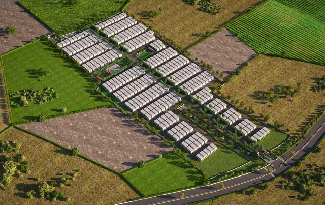
NAKSHTRA is a plotted development in LAKDARAM, PATANCHERU mandal, Sangareddy district, developed by registered promoter LAND BASE VENTURES. The site area is 106458.96 SQ.MT., with net area 102887.16; the layout drawing identifies 355 numbered plots. The project is registered with TG-RERA under P01100004155, with proposed completion 30/11/2026.
01What we found
Read from TG-RERA filings, approvals, land and registration records and court records. A court case is counted only when the court record states this project's survey number with its village, or names the project.
02Check before you pay
10 items to check before you pay, 5 high - from the title chain, court records and approvals, each with what to ask the builder or your advocate. An item may not be a problem with the project: records can be incomplete.
1. Project at a glance
Project identity
| Item | Project record |
|---|---|
| Registered name | NAKSHTRA RERA record |
| Project type | Plotted development; the HMDA filing describes an open residential layout. RERA record |
| Phase / registered portion | No phase name or phase number is disclosed. TG-RERA registration covers survey numbers 504/PART, 505/PART, 506/PART and 507/PART. |
| TG-RERA registration | P01100004155; certificate records grant under section 5 on 25/02/2022. |
| Registration validity | Certificate states commencement 25/02/2022 and end 13/03/2026; it records no extension. This is registration validity, not the project completion deadline. |
| Registered promoter | LAND BASE VENTURES, a partnership. RERA record Corporate record |
| RERA status | The filing identifies the project as New Project. The supplied certificate records the registration dates above; a current registration-status verification is not supplied. RERA record |
Land and geographic identity
| Item | Project record |
|---|---|
| Locality / revenue village | LAKDARAM (the HMDA documents spell the village “Lakdaram”). RERA record |
| Mandal / district / PIN | PATANCHERU mandal; Sangareddy district; 502319. RERA record |
| TG-RERA survey numbers | 504/PART, 505/PART, 506/PART and 507/PART. |
| HMDA layout drawing survey references | 503 PART, 504, 505 PART, 506 PART and 507 PART. |
| Site extent | HMDA plan states total plot/site area 106458.96 SQ.MT., road-widening area 3571.80, and net area 102887.16. The layout drawing’s land-use statement uses net layout area 102887.16 sq.m. |
| Boundaries (RERA filing) | North: LADKARAM VILLAGE ROAD; south: NEGHIBOURS LAND; east and west: NEIGHBOURS LAND. RERA filing |
Development identity
| Item | Project record |
|---|---|
| Sanctioning authority | Hyderabad Metropolitan Development Authority (HMDA). |
| Principal layout approval | 000208/LO/Plg/HMDA/2021, dated 07-05-2021; application/file number 037062/SKP/LT/U6/HMDA/03072020. The RERA filing also lists 000208/LO/Plg/HMDA/2 as the plan approval number. Approvals record |
| Approval character | The filed document is described as HMDA technical approval / draft layout approval for a proposed residential open-plot layout. It does not identify a building or apartment scheme. |
| Approved built-up area | RERA project information lists 59641 sqmts as approved built-up area; the supplied layout documents do not explain this figure as building area for the plotted layout. RERA filing |
| Buildings / floors | Not disclosed for this plotted layout; no building count or floor configuration is established by the supplied records. |
| Plot layout area allocation | Plotted area 63397.32 sq.m; roads 28004.42 sq.m; organized open space/park/utility area 8654.18 sq.m; social infrastructure area 2830.22 sq.m. The plan separately records amenity area 0.00. |
| HMDA-mortgaged plots | Drawing identifies plots 287 to 342 and 27 to 38, 345 to 349—73 plots in total—with stated mortgage extent 12970.66 sq.m, in favour of HMDA. |
Offering and status
| Item | Project record |
|---|---|
| Offered unit type | Plots; individual RERA plot inventory, dimensions and availability are not supplied. RERA record RERA unit table |
| Plot count / size information | Drawing-derived software reading identifies 355 numbered plots (1 to 355); sizes were read for 308 plots. Recorded range: 18.29–531.19 sq.m (software-measured from the layout drawing, not a RERA unit schedule). Layout record |
| Booked / available counts | Not established in the supplied evidence. RERA unit table |
| Construction / development stage | No independently verified site-progress evidence or RERA-declared completion percentage is supplied. RERA amenities Document index |
| Completion dates | HMDA draft layout letter directs developmental works to be completed within THREE (3) YEARS; the supplied RERA Form B declarations state completion undertakings of 31/03/2023 and 06/05/2024. The RERA header lists proposed completion 30/11/2026. These are stated in their respective records and are not site-verification findings. RERA record |
| Occupancy / completion certificate | No project completion certificate or occupancy certificate is supplied. For this plotted development, the supplied documents do not establish an OC for the layout or any portion. Document index |
2. The project story
- NAKSHTRA is registered with TG-RERA as a plotted development by LAND BASE VENTURES. The RERA registration identifies the project land as 504/PART, 505/PART, 506/PART and 507/PART in Lakdaram, Patancheru mandal, Sangareddy district. HMDA’s filed layout documents describe a proposed residential open-plot layout and include 503 PART as well as 504, 505 PART, 506 PART and 507 PART in the drawing references. RERA record
- The layout drawing allocates land to plots, roads, open space/park/utility and social infrastructure. It shows 73 plots mortgaged to HMDA and states that plots other than the mortgaged plots may be sold. This is an approval-document statement, not evidence of current plot-by-plot sale availability.
- The supplied material does not establish the present physical construction or infrastructure-completion stage through an independently verified site inspection or a current progress certificate. The RERA filing’s proposed completion date and the Form B undertakings are declarations, while the HMDA letter’s three-year direction is an approval condition; none alone verifies actual completion. No occupancy or completion certificate is included. RERA record Document index
3. Master plan, architecture & building design
This is a plotted layout, not a documented apartment or multi-storey building project. HMDA’s filed plan identifies residential plot use and an open-layout development. The stated site area is 106458.96 SQ.MT., with 3571.80 recorded as road-widening area and net area 102887.16 sq.m.
The drawing-derived land-use statement records:
| Layout component | Area | Source description |
|---|---|---|
| Plotted area | 63397.32 sq.m | “Plotted Area” |
| Roads | 28004.42 sq.m | “Road Area” |
| Organized open space / park / utility area | 8654.18 sq.m | “Organized open space/park Area/Uitility Area” |
| Social infrastructure | 2830.22 sq.m | “Social Infrastructure Area” |
| Amenity area | 0.00 | HMDA technical-approval extract |
- The drawing includes road-width references of 30.00, 12.19M (40'-0'), 9.14M (30'-0'), 10.06 M (33'-0') and PROPOSED 100ft WIDE ROAD. These are drawing labels; no separate road-by-road completion verification is supplied.
- The layout software reading identifies 355 plot numbers (1–355) and records plot sizes for 308; the supplied size summary ranges from 18.29 sq.m to 531.19 sq.m, with a software-measured median of 200.0 sq.m. These are drawing-derived readings, not a RERA-filed plot schedule. Layout record
- No building footprint, sanctioned building floors, apartment configuration, building height or FSI-counted area is established for this plotted-layout evidence. The RERA information field reports approved built-up area of 59641 sqmts, but the supplied documents do not define its application to the layout. RERA filing Document index
4. Homes, configurations & floor plans
The RERA-recorded offering is plots; the supplied evidence does not include a plot-by-plot RERA inventory with booked, available or saleable-area figures. Accordingly, those counts and areas cannot be reported as established. RERA record RERA unit table
| Configuration | Units | Booked | Available | RERA saleable area | Measured carpet area | Loading (if supplied) |
|---|---|---|---|---|---|---|
| Plots | Not established in supplied RERA inventory | Not supplied | Not supplied | Not supplied | Not applicable / not supplied | Not supplied |
The layout drawing’s software-measured reading identifies 355 numbered plots and provides sizes for 308. Its recorded size bands are: 0–100 sq.yd: 1 plot; 150–200 sq.yd: 15; 200–250 sq.yd: 194; 250–300 sq.yd: 67; 300–400 sq.yd: 12; 400–500 sq.yd: 11; 500–1000 sq.yd: 8. These are software-measured from the drawing, not RERA-filed unit areas or a verified available-inventory schedule. Layout record
No apartment floor plans or measured carpet areas apply in the supplied evidence. The drawing review reports one layout sheet and no flat-bearing drawings. Floor plans
5. Parking & vehicle circulation
The supplied layout records internal roads and road-width labels, but does not establish a sanctioned parking-space count, visitor or accessible parking provision, or plot-specific parking allocation. No exclusive parking right for a particular buyer is established by a drawn or filed provision.
6. Amenities, recreation & open spaces
The RERA amenities record marks several layout-level facilities “YES” but reports 0 progress for each listed item; this is a filed status, not independent verification of completion. HMDA’s draft layout approval also specifies development conditions and identifies facilities in its plan documents. RERA amenities
| Description / size | Road area 28004.42 sq.m; approval references road widths including 12.19M (40'-0'), 9.14M (30'-0'), 10.06 M (33'-0') and PROPOSED 100ft WIDE ROAD. |
|---|---|
| Evidence source | HMDA layout drawing; RERA amenities RERA amenities |
| Declared progress / verified status | RERA amenity entry marked “YES”; 0 progress. Completion not independently verified. |
| Description / size | Organized open space/park/utility area 8654.18 sq.m in the layout area statement. |
|---|---|
| Evidence source | HMDA layout drawing; RERA amenities RERA amenities |
| Declared progress / verified status | RERA entry marked “YES”; 0 progress. Completion not independently verified. |
| Description / size | 2830.22 sq.m. |
|---|---|
| Evidence source | HMDA layout documents |
| Declared progress / verified status | Area is shown in the approval documents; a specific facility or completed building is not established. |
| Description / size | Layout-level water-supply entry; HMDA conditions require arrangements for potable/drinking-water supply. RERA amenities |
|---|---|
| Evidence source | RERA amenities and HMDA condition RERA amenities |
| Declared progress / verified status | RERA entry marked “YES”; 0 progress. Completion not independently verified. |
| Description / size | Approval document lists a common septic tank/STP and requires provision for a sewerage treatment plant. |
|---|---|
| Evidence source | HMDA approval documents; RERA amenities RERA amenities |
| Declared progress / verified status | RERA sewerage entry marked “YES”; 0 progress. Completion not independently verified. |
| Description / size | HMDA conditions require an underground storm-water drainage system; the document also lists storm-water drains. |
|---|---|
| Evidence source | HMDA approval documents; RERA amenities RERA amenities |
| Declared progress / verified status | RERA entry marked “YES”; 0 progress. Completion not independently verified. |
| Description / size | HMDA approval document lists rainwater-harvesting pits; RERA amenities list water conservation/rainwater harvesting. RERA amenities |
|---|---|
| Evidence source | HMDA approval documents and RERA amenities RERA amenities |
| Declared progress / verified status | RERA entry marked “YES”; 0 progress. Completion not independently verified. |
| Description / size | Approval document lists street lights and a transformer; conditions refer to LED street lighting and a transformer yard in the area earmarked for utilities. |
|---|---|
| Evidence source | HMDA approval documents; RERA amenities RERA amenities |
| Declared progress / verified status | RERA electrical meter room/sub-station/receiving station entry marked “YES”; 0 progress. Completion not independently verified. |
| Description / size | Listed among the layout plan’s amenities/utilities. |
|---|---|
| Evidence source | HMDA layout document |
| Declared progress / verified status | No separate RERA progress or completion evidence supplied. |
7. Utilities, building services & safety
- The HMDA layout documents specify or list potable-water arrangements, water-supply pipe lines and an overhead tank; common septic tank/STP and sewerage infrastructure; underground storm-water drainage; underground ducting of utilities; transformer and street-lighting infrastructure; rainwater-harvesting pits; and solid-waste arrangements, including segregation and a designated disposal/dumping space. These are approval-document requirements or listed facilities, not evidence that they are installed or operating.
- The RERA amenities record marks water supply, sewerage, storm-water drains, water conservation/rainwater harvesting, street lighting and electrical meter room/sub-station/receiving station “YES,” each with 0 progress recorded. It does not provide capacities, completion evidence or operating details. RERA amenities
- No project-specific evidence establishes fire-protection systems, lifts, backup power, CCTV, access control, accessible circulation or completed utility services. The layout is plotted; building-specific vertical-transportation and fire-system details are not supplied. Document index RERA amenities
8. Location, access & connectivity
The registered project location is LAKDARAM, Patancheru mandal, Sangareddy district, Telangana, PIN 502319. The RERA-filed boundary description identifies LADKARAM VILLAGE ROAD to the north and neighbouring land to the east, west and south. RERA record RERA filing
The HMDA drawing describes an abutting road width of 30.00 and includes internal road-width labels. A location record provides a nearest sampled Outer Ring Road interchange distance of 8.4 km. No travel time is supplied. Location record
9. Developer & development status
- The registered promoter is LAND BASE VENTURES, identified in the RERA information as a Partnership, with GSTIN 36AAIFL2517R1ZT. The listed partners are Y S ANIL REDDY and Y S SUNIL REDDY; SOLIPURAM RANJITH REDDY is identified as an authorized signatory. Corporate record Parties record
- The RERA certificate gives the promoter office as “Village: Mandal: District: Ranga Reddy, Pin: 500034”; the structured promoter record separately gives an address in Arora Colony, Lakdaram, Patancheru, Sangareddy, PIN 502319. No official website or contact details are supplied. Parties record
- The Form B filed in 2021 records a promoter completion undertaking of 31/03/2023; the Form B filed in 2022 records 06/05/2024. The RERA header lists proposed completion 30/11/2026. The evidence does not provide a current independently verified construction-progress assessment or an occupancy/completion certificate. RERA record Document index
10. Approvals, official records & documents
| Record | Supplied evidence and scope |
|---|---|
| TG-RERA registration certificate | FORM ‘C’ records registration P01100004155 for NAKSHTRA, promoter LAND BASE VENTURES, with validity stated as 25/02/2022–13/03/2026. |
| HMDA layout approval / plan | 000208/LO/Plg/HMDA/2021, dated 07-05-2021, application/file 037062/SKP/LT/U6/HMDA/03072020; filed as technical/draft residential layout approval. |
| Additional HMDA plan copy | Technical approval of a draft layout; its extracted survey references include 503 PART, 504, 505 PART, 506 PART, 507 PART, 53 PART, 603 PART, S06 PART and 607 PART. |
| Commencement-certificate upload | Document labelled “Commencement Certificates for each building in each phase” is described as the HMDA draft layout letter; it does not establish a building-specific commencement certificate. |
| Other commencement-certificate upload | OCR is too garbled to identify the document type, authority, land or approval terms reliably. |
| Form B declarations | Promoter-filed declarations dated 20 May 2021 and 12-02-2022, containing title/encumbrance statements and completion undertakings. |
| Layout-area and facility evidence | HMDA layout drawing and approval extracts show the stated land-use areas, road references, utility provisions and HMDA-mortgaged plots. |
| Occupancy/completion certificate | None supplied for the layout or any portion. Document index |
The HMDA layout documents state that layout permission is not proof of title and specify that certain plots are mortgaged in favour of HMDA. This Overview reports those document contents; it does not determine title, saleability or current approval status.
1. Project at a glance
Project identity
Registered name: NAKSHTRA
Project type: Plotted development; the HMDA filing describes an open residential layout.
Phase / registered portion: No phase name or phase number is disclosed. TG-RERA registration covers survey numbers 504/PART, 505/PART, 506/PART and 507/PART.
TG-RERA registration: P01100004155; certificate records grant under section 5 on 25/02/2022.
Registration validity: Certificate states commencement 25/02/2022 and end 13/03/2026; it records no extension. This is registration validity, not the project completion deadline.
Registered promoter: LAND BASE VENTURES, a partnership.
RERA status: The filing identifies the project as New Project. The supplied certificate records the registration dates above; a current registration-status verification is not supplied.
Land and geographic identity
Locality / revenue village: LAKDARAM (the HMDA documents spell the village “Lakdaram”).
Mandal / district / PIN: PATANCHERU mandal; Sangareddy district; 502319.
TG-RERA survey numbers: 504/PART, 505/PART, 506/PART and 507/PART.
HMDA layout drawing survey references: 503 PART, 504, 505 PART, 506 PART and 507 PART.
Site extent: HMDA plan states total plot/site area 106458.96 SQ.MT., road-widening area 3571.80, and net area 102887.16. The layout drawing’s land-use statement uses net layout area 102887.16 sq.m.
Boundaries (RERA filing): North: LADKARAM VILLAGE ROAD; south: NEGHIBOURS LAND; east and west: NEIGHBOURS LAND.
Development identity
Sanctioning authority: Hyderabad Metropolitan Development Authority (HMDA).
Principal layout approval: 000208/LO/Plg/HMDA/2021, dated 07-05-2021; application/file number 037062/SKP/LT/U6/HMDA/03072020. The RERA filing also lists 000208/LO/Plg/HMDA/2 as the plan approval number.
Approval character: The filed document is described as HMDA technical approval / draft layout approval for a proposed residential open-plot layout. It does not identify a building or apartment scheme.
Approved built-up area: RERA project information lists 59641 sqmts as approved built-up area; the supplied layout documents do not explain this figure as building area for the plotted layout.
Buildings / floors: Not disclosed for this plotted layout; no building count or floor configuration is established by the supplied records.
Plot layout area allocation: Plotted area 63397.32 sq.m; roads 28004.42 sq.m; organized open space/park/utility area 8654.18 sq.m; social infrastructure area 2830.22 sq.m. The plan separately records amenity area 0.00.
HMDA-mortgaged plots: Drawing identifies plots 287 to 342 and 27 to 38, 345 to 349—73 plots in total—with stated mortgage extent 12970.66 sq.m, in favour of HMDA.
Offering and status
Offered unit type: Plots; individual RERA plot inventory, dimensions and availability are not supplied.
Plot count / size information: Drawing-derived software reading identifies 355 numbered plots (1 to 355); sizes were read for 308 plots. Recorded range: 18.29–531.19 sq.m (software-measured from the layout drawing, not a RERA unit schedule).
Booked / available counts: Not established in the supplied evidence.
Construction / development stage: No independently verified site-progress evidence or RERA-declared completion percentage is supplied.
Completion dates: HMDA draft layout letter directs developmental works to be completed within THREE (3) YEARS; the supplied RERA Form B declarations state completion undertakings of 31/03/2023 and 06/05/2024. The RERA header lists proposed completion 30/11/2026. These are stated in their respective records and are not site-verification findings.
Occupancy / completion certificate: No project completion certificate or occupancy certificate is supplied. For this plotted development, the supplied documents do not establish an OC for the layout or any portion.
2. The project story
- NAKSHTRA is registered with TG-RERA as a plotted development by LAND BASE VENTURES. The RERA registration identifies the project land as 504/PART, 505/PART, 506/PART and 507/PART in Lakdaram, Patancheru mandal, Sangareddy district. HMDA’s filed layout documents describe a proposed residential open-plot layout and include 503 PART as well as 504, 505 PART, 506 PART and 507 PART in the drawing references.
- The layout drawing allocates land to plots, roads, open space/park/utility and social infrastructure. It shows 73 plots mortgaged to HMDA and states that plots other than the mortgaged plots may be sold. This is an approval-document statement, not evidence of current plot-by-plot sale availability.
- The supplied material does not establish the present physical construction or infrastructure-completion stage through an independently verified site inspection or a current progress certificate. The RERA filing’s proposed completion date and the Form B undertakings are declarations, while the HMDA letter’s three-year direction is an approval condition; none alone verifies actual completion. No occupancy or completion certificate is included.
3. Master plan, architecture & building design
This is a plotted layout, not a documented apartment or multi-storey building project. HMDA’s filed plan identifies residential plot use and an open-layout development. The stated site area is 106458.96 SQ.MT., with 3571.80 recorded as road-widening area and net area 102887.16 sq.m.
The drawing-derived land-use statement records:
| Layout component | Area | Source description |
|---|---|---|
| Plotted area | 63397.32 sq.m | “Plotted Area” |
| Roads | 28004.42 sq.m | “Road Area” |
| Organized open space / park / utility area | 8654.18 sq.m | “Organized open space/park Area/Uitility Area” |
| Social infrastructure | 2830.22 sq.m | “Social Infrastructure Area” |
| Amenity area | 0.00 | HMDA technical-approval extract |
- The drawing includes road-width references of 30.00, 12.19M (40'-0'), 9.14M (30'-0'), 10.06 M (33'-0') and PROPOSED 100ft WIDE ROAD. These are drawing labels; no separate road-by-road completion verification is supplied.
- The layout software reading identifies 355 plot numbers (1–355) and records plot sizes for 308; the supplied size summary ranges from 18.29 sq.m to 531.19 sq.m, with a software-measured median of 200.0 sq.m. These are drawing-derived readings, not a RERA-filed plot schedule.
- No building footprint, sanctioned building floors, apartment configuration, building height or FSI-counted area is established for this plotted-layout evidence. The RERA information field reports approved built-up area of 59641 sqmts, but the supplied documents do not define its application to the layout.
4. Homes, configurations & floor plans
The RERA-recorded offering is plots; the supplied evidence does not include a plot-by-plot RERA inventory with booked, available or saleable-area figures. Accordingly, those counts and areas cannot be reported as established.
| Configuration | Units | Booked | Available | RERA saleable area | Measured carpet area | Loading (if supplied) |
|---|---|---|---|---|---|---|
| Plots | Not established in supplied RERA inventory | Not supplied | Not supplied | Not supplied | Not applicable / not supplied | Not supplied |
The layout drawing’s software-measured reading identifies 355 numbered plots and provides sizes for 308. Its recorded size bands are: 0–100 sq.yd: 1 plot; 150–200 sq.yd: 15; 200–250 sq.yd: 194; 250–300 sq.yd: 67; 300–400 sq.yd: 12; 400–500 sq.yd: 11; 500–1000 sq.yd: 8. These are software-measured from the drawing, not RERA-filed unit areas or a verified available-inventory schedule.
No apartment floor plans or measured carpet areas apply in the supplied evidence. The drawing review reports one layout sheet and no flat-bearing drawings.
5. Parking & vehicle circulation
The supplied layout records internal roads and road-width labels, but does not establish a sanctioned parking-space count, visitor or accessible parking provision, or plot-specific parking allocation. No exclusive parking right for a particular buyer is established by a drawn or filed provision.
6. Amenities, recreation & open spaces
The RERA amenities record marks several layout-level facilities “YES” but reports 0 progress for each listed item; this is a filed status, not independent verification of completion. HMDA’s draft layout approval also specifies development conditions and identifies facilities in its plan documents.
| Description / size | Road area 28004.42 sq.m; approval references road widths including 12.19M (40'-0'), 9.14M (30'-0'), 10.06 M (33'-0') and PROPOSED 100ft WIDE ROAD. |
|---|---|
| Evidence source | HMDA layout drawing; RERA amenities |
| Declared progress / verified status | RERA amenity entry marked “YES”; 0 progress. Completion not independently verified. |
| Description / size | Organized open space/park/utility area 8654.18 sq.m in the layout area statement. |
|---|---|
| Evidence source | HMDA layout drawing; RERA amenities |
| Declared progress / verified status | RERA entry marked “YES”; 0 progress. Completion not independently verified. |
| Description / size | 2830.22 sq.m. |
|---|---|
| Evidence source | HMDA layout documents |
| Declared progress / verified status | Area is shown in the approval documents; a specific facility or completed building is not established. |
| Description / size | Layout-level water-supply entry; HMDA conditions require arrangements for potable/drinking-water supply. |
|---|---|
| Evidence source | RERA amenities and HMDA condition |
| Declared progress / verified status | RERA entry marked “YES”; 0 progress. Completion not independently verified. |
| Description / size | Approval document lists a common septic tank/STP and requires provision for a sewerage treatment plant. |
|---|---|
| Evidence source | HMDA approval documents; RERA amenities |
| Declared progress / verified status | RERA sewerage entry marked “YES”; 0 progress. Completion not independently verified. |
| Description / size | HMDA conditions require an underground storm-water drainage system; the document also lists storm-water drains. |
|---|---|
| Evidence source | HMDA approval documents; RERA amenities |
| Declared progress / verified status | RERA entry marked “YES”; 0 progress. Completion not independently verified. |
| Description / size | HMDA approval document lists rainwater-harvesting pits; RERA amenities list water conservation/rainwater harvesting. |
|---|---|
| Evidence source | HMDA approval documents and RERA amenities |
| Declared progress / verified status | RERA entry marked “YES”; 0 progress. Completion not independently verified. |
| Description / size | Approval document lists street lights and a transformer; conditions refer to LED street lighting and a transformer yard in the area earmarked for utilities. |
|---|---|
| Evidence source | HMDA approval documents; RERA amenities |
| Declared progress / verified status | RERA electrical meter room/sub-station/receiving station entry marked “YES”; 0 progress. Completion not independently verified. |
| Description / size | Listed among the layout plan’s amenities/utilities. |
|---|---|
| Evidence source | HMDA layout document |
| Declared progress / verified status | No separate RERA progress or completion evidence supplied. |
7. Utilities, building services & safety
- The HMDA layout documents specify or list potable-water arrangements, water-supply pipe lines and an overhead tank; common septic tank/STP and sewerage infrastructure; underground storm-water drainage; underground ducting of utilities; transformer and street-lighting infrastructure; rainwater-harvesting pits; and solid-waste arrangements, including segregation and a designated disposal/dumping space. These are approval-document requirements or listed facilities, not evidence that they are installed or operating.
- The RERA amenities record marks water supply, sewerage, storm-water drains, water conservation/rainwater harvesting, street lighting and electrical meter room/sub-station/receiving station “YES,” each with 0 progress recorded. It does not provide capacities, completion evidence or operating details.
- No project-specific evidence establishes fire-protection systems, lifts, backup power, CCTV, access control, accessible circulation or completed utility services. The layout is plotted; building-specific vertical-transportation and fire-system details are not supplied.
8. Location, access & connectivity
The registered project location is LAKDARAM, Patancheru mandal, Sangareddy district, Telangana, PIN 502319. The RERA-filed boundary description identifies LADKARAM VILLAGE ROAD to the north and neighbouring land to the east, west and south.
The HMDA drawing describes an abutting road width of 30.00 and includes internal road-width labels. A location record provides a nearest sampled Outer Ring Road interchange distance of 8.4 km. No travel time is supplied.
9. Developer & development status
- The registered promoter is LAND BASE VENTURES, identified in the RERA information as a Partnership, with GSTIN 36AAIFL2517R1ZT. The listed partners are Y S ANIL REDDY and Y S SUNIL REDDY; SOLIPURAM RANJITH REDDY is identified as an authorized signatory.
- The RERA certificate gives the promoter office as “Village: Mandal: District: Ranga Reddy, Pin: 500034”; the structured promoter record separately gives an address in Arora Colony, Lakdaram, Patancheru, Sangareddy, PIN 502319. No official website or contact details are supplied.
- The Form B filed in 2021 records a promoter completion undertaking of 31/03/2023; the Form B filed in 2022 records 06/05/2024. The RERA header lists proposed completion 30/11/2026. The evidence does not provide a current independently verified construction-progress assessment or an occupancy/completion certificate.
10. Approvals, official records & documents
TG-RERA registration certificate: FORM ‘C’ records registration P01100004155 for NAKSHTRA, promoter LAND BASE VENTURES, with validity stated as 25/02/2022–13/03/2026.
HMDA layout approval / plan: 000208/LO/Plg/HMDA/2021, dated 07-05-2021, application/file 037062/SKP/LT/U6/HMDA/03072020; filed as technical/draft residential layout approval.
Additional HMDA plan copy: Technical approval of a draft layout; its extracted survey references include 503 PART, 504, 505 PART, 506 PART, 507 PART, 53 PART, 603 PART, S06 PART and 607 PART.
Commencement-certificate upload: Document labelled “Commencement Certificates for each building in each phase” is described as the HMDA draft layout letter; it does not establish a building-specific commencement certificate.
Other commencement-certificate upload: OCR is too garbled to identify the document type, authority, land or approval terms reliably.
Form B declarations: Promoter-filed declarations dated 20 May 2021 and 12-02-2022, containing title/encumbrance statements and completion undertakings.
Layout-area and facility evidence: HMDA layout drawing and approval extracts show the stated land-use areas, road references, utility provisions and HMDA-mortgaged plots.
Occupancy/completion certificate: None supplied for the layout or any portion.
The HMDA layout documents state that layout permission is not proof of title and specify that certain plots are mortgaged in favour of HMDA. This Overview reports those document contents; it does not determine title, saleability or current approval status.
Frequently asked questions
Is NAKSHTRA registered with Telangana RERA?
Yes. NAKSHTRA is registered with the Telangana Real Estate Regulatory Authority as P01100004155; the registration status is New Project.
Who is the developer of NAKSHTRA?
The promoter named in the RERA registration is LAND BASE VENTURES.
Where is NAKSHTRA located?
NAKSHTRA is in LAKDARAM, PATANCHERU, Sangareddy, Telangana (502319).
When will NAKSHTRA be completed?
The promoter's proposed date of completion filed with RERA is 30/11/2026. This is the promoter's declaration, not a guarantee.
More projects in Lakdaram