Ira Urban Ranch
IRA URBAN RANCH LLP · Rangareddy · RERA P02400009631
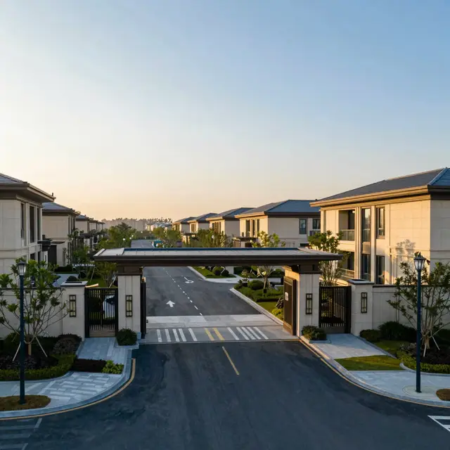
IRA URBAN RANCH is a residential villa / gated-community layout in Kongarakalan, Ibrahimpatnam Mandal, Ranga Reddy District, developed by registered promoter IRA URBAN RANCH LLP. The HMDA filing records a total site area of 78,894.30 sq.m and 164 plots/villas; the residential plot/villa groupings are marked for 3 floors, and the RERA unit table records 162 units labelled “G PLUS 2” at 386.45 sq.m and one labelled “G PLUS TWO” at 457.82 sq.m. The project is registered under TG-RERA number P02400009631, and the Form B declaration undertakes completion by 17.04.2030.
01What we found
Read from TG-RERA filings, approvals, land and registration records and court records. A court case is counted only when the court record states this project's survey number with its village, or names the project.
02Check before you pay
8 items to check before you pay, 3 high - from the title chain, court records and approvals, each with what to ask the builder or your advocate. An item may not be a problem with the project: records can be incomplete.
1. Project at a glance
Project identity
| Item | Project record |
|---|---|
| Registered project name | IRA URBAN RANCH RERA record |
| Project type | Residential, villa / gated-community layout in the TG-RERA record; the HMDA filing also describes a layout with housing. RERA record RERA filing |
| Phase / registered portion | Phase not separately identified. The registered project covers the land described in the RERA certificate; whether this is a phase of a wider development is not disclosed. |
| TG-RERA registration | P02400009631; registration effective 18 April 2025. RERA record |
| Registration validity | The Form C certificate states validity from 18/04/2025 to 17/04/2030, unless extended by the Authority. This is the registration period, not the project’s completion deadline. |
| Registered promoter | IRA URBAN RANCH LLP. RERA record Corporate record |
| RERA status | Registration certificate is recorded as executed; the registration number is available. Document index |
Land and geographic identity
| Item | Project record |
|---|---|
| Locality / PIN | Near Narayana College, Kongarakalan, PIN 501510. RERA record RERA filing |
| Revenue village | Kongarakalan (also rendered “Kongara Kalan” in approval-document extracts). RERA record |
| Mandal / district | Ibrahimpatnam Mandal, Ranga Reddy District. RERA record |
| Project survey numbers and subdivisions | The RERA certificate identifies 39/Part, 40/Part, 41/Part and 60/Part. The HMDA layout filing lists these subdivisions: 41/AA/A/2, 60/LU/2, 41/AA/AA/2, 41/AA/A/1/2, 41/AA6/1/2, 60/LU/1/1, 41/AA/A/1/1/1, 41/AA/A/1/1/2, 41/AA1/1/1, 41AA1/1/2, 40/E/3, 60/LU/1/2, 40/A/6, 41/AA/3, 41/AA/4, 41AA2/A2, 41AA2/A3, 41/AA/AA2, 41/AA2/AA2, 41/AA2/E2, 41/AA2/EE2, 41/AA/EE3, 41/AA2/E3, 41/A/1, 41/AA/1/2, 41/AA 6/2, 39/A1/1, 41/AA/AA/1/2, 41A1/4, 41/A1/4, 39A2, 60/UU, 60/EEU, 41/AA1, 40EE1, 63AA, 40E, 41AA1/3, AA/AA/1/1, 41AA6/1/1/1 and 41AA/1. The approval extract also lists 39A1/1. |
| Site area | HMDA filing: total site area 78,894.30 sq.m; net site area 78,664.95 sq.m. |
| Boundaries | RERA filing: east—Neighbours Land; west—Land of IRA; north—40 feet wide Road; south—Land of Others. RERA filing |
Development identity
| Item | Project record |
|---|---|
| Sanctioning authority | Hyderabad Metropolitan Development Authority (HMDA). RERA record |
| Principal layout approval | 004932/LO/HMDA/1086/SMD/2024, dated 18 April 2025. Approvals record |
| Approved built-up area | HMDA extract records Total Built up Area 58255.07; the same filed extract does not state a unit alongside that figure. |
| Building / villa count | HMDA filing records 164 plots/villas. The RERA portal-derived unit data records 164 blocks but 163 named villas; the layout drawing states 164 plots. Layout record RERA unit table |
| Floor configuration | The approval drawing labels the clubhouse as 5 floors and residential plot/villa groupings as 3 floors. A building-by-building configuration is not available in the supplied record. |
| Parking | A 22.00 m long, 3.00 m high, 6.00 m wide vehicular ramp is shown on the drawing; a sanctioned parking-space count and parking-level schedule are not provided in the supplied extracts. |
| Unit count | HMDA filing: 164 plots/villas; RERA portal-derived unit table: 163 homes. The RERA table also includes non-home floor/common-area rows. RERA unit table RERA unit details |
Offering and status
| Item | Project record |
|---|---|
| Unit type | Villas / plotted villa layout; the RERA unit table does not provide a conventional villa configuration name. RERA record RERA unit table |
| RERA-filed saleable area | The RERA unit table lists 162 units at 386.45 sq.m and one unit at 457.82 sq.m. The filing labels these entries “G PLUS 2” and “G PLUS TWO,” rather than a villa configuration. RERA unit table RERA unit details |
| Booked / available | Portal-derived record shows 0 booked and 163 available. The portal extract has no as-of date, so counts are indicative. RERA unit table RERA unit details |
| Construction stage | No construction-progress percentage or independently verified site-stage evidence is supplied. The approval material describes development obligations and the RERA Form B contains a completion undertaking. |
| Completion deadline | The RERA Form B declaration undertakes completion by 17.04.2030. A separate header field gives proposed completion as 17/08/2030; the supplied record does not establish a revised completion date. RERA record |
| Occupancy / completion certificate | No project occupancy certificate or completion certificate is identified in the supplied evidence. Tower-wise or phase-wise OC status is not disclosed. Document index |
2. The project story
- IRA URBAN RANCH is registered as a residential project in Kongarakalan, Ibrahimpatnam Mandal, Ranga Reddy District. The filed layout and approval materials describe a gated community of 164 plots/villas, with residential development, internal roads, open space and utilities. The approval drawing depicts residential groupings marked for three floors and a five-floor clubhouse. RERA record
- The TG-RERA portal-derived record lists 163 homes as available and none as booked, but does not date that inventory snapshot. No reliable construction-progress figure or independently verified site inspection is included here. The RERA certificate is valid through 17 April 2030 unless extended; separately, the Form B affidavit undertakes completion by 17 April 2030. No occupancy or completion certificate is shown in the supplied documents. RERA unit table
3. Master plan, architecture & building design
- The HMDA filing records a total site area of 78,894.30 sq.m and net site area of 78,664.95 sq.m. Its land-use statement identifies 44,715.98 sq.m as plotted area, 25,438.53 sq.m as layout roads, 7,927.29 sq.m as open space/park and 812.84 sq.m as utilities. These are figures from the approval-file extract, not a separately measured site survey.
- The plan describes 164 plots/villas and depicts a gated-community layout with internal roads labelled 12M, 10.05M and 9M wide; it also identifies a 12.19 m existing road and a 12.19 m proposed road. The drawing labels a clubhouse and groups of residential plots/villas, with residential buildings marked as three floors and the clubhouse as five floors. It does not provide a complete building-by-building schedule, floor-area breakdown by use, or verified construction status.
- The HMDA document extract records Total Built up Area 58255.07 without a unit in that field. A separate drawing extract lists proposed built-up areas both excluding and including parking, but the supplied records do not establish a single reconciled area figure. The approved-layout lookup on the public HMDA DPMS portal was unavailable to the evidence provider; the filed drawing and approval documents are therefore the available plan evidence, not an independent portal confirmation. HMDA
4. Homes, configurations & floor plans
The RERA unit table records 163 homes under floor labels rather than conventional villa configuration names. The project evidence also contains software-measured plan data labelled “1BHK”; it is not matched to a RERA-filed configuration, so it should not be treated as the project’s RERA villa offering. RERA unit table RERA unit details Floor plans
| Configuration | Units | Booked | Available | RERA saleable area | Measured carpet area | Loading (if supplied) |
|---|---|---|---|---|---|---|
| “G PLUS 2” (RERA filing label) | 162 | 0 | 162 | 386.45 sq.m | Not supplied for a matched configuration | Not supplied |
| “G PLUS TWO” (RERA filing label) | 1 | 0 | 1 | 457.82 sq.m | Not supplied for a matched configuration | Not supplied |
| 1BHK (drawing-measured; not matched to RERA configuration) | Not filed as a RERA home configuration | — | — | Not filed | Software-measured: 95.5–105.4 sq.m; median 100.3 sq.m (median 1080 sq.ft) | Not supplied |
The 1BHK measurement is based on drawing geometry from document 555670, is not a RERA disclosure, and is flagged as needing review. Carpet area and RERA saleable area are different measures; the supplied evidence does not provide a matched floor-plan comparison or loading figure for the recorded homes. Floor plans RERA unit details
5. Parking & vehicle circulation
The layout drawing shows a vehicular ramp measuring 22.00 m long, 3.00 m high and 6.00 m wide, and identifies internal roads of 12 m, 10.05 m and 9 m. It does not provide a verified parking-space count, parking level or bay-allocation schedule.
The HMDA filing records four mortgaged plots/villas measuring 3212.58 sq.m in favour of the Metropolitan Commissioner, HMDA; these are authority-security plots, not evidence of parking provision or purchaser parking allocation. The supplied evidence does not establish resident, visitor, accessible or EV parking numbers, or exclusive parking rights for any unit.
6. Amenities, recreation & open spaces
The HMDA plan extract identifies a clubhouse, tot-lot, green strip, park/open space and utility land. Its land-use statement records 7,927.29 sq.m of open space/park. A separate amenities extract lists infrastructure categories as available, each with 0% progress; this is a filed status entry, not independent verification of completion. RERA amenities
| Description / size | Drawing labels clubhouse dimensions 28.50 m × 46.50 m and plot area 1325.25; the drawing marks it as five floors. |
|---|---|
| Evidence source | Approved-layout drawing extract |
| Declared progress / verified status | Shown on drawing; construction or completion not independently verified. |
| Description / size | 7,927.29 sq.m in the HMDA land-use statement. |
|---|---|
| Evidence source | HMDA filing |
| Declared progress / verified status | Required development/hand-over is described in approval conditions; completion not independently verified. |
| Description / size | Identified on the layout drawing. |
|---|---|
| Evidence source | Approved-layout drawing extract |
| Declared progress / verified status | Shown on drawing; progress not independently verified. |
| Description / size | Identified in the amenities record; layout drawing labels internal roads at 12 m, 10.05 m and 9 m. |
|---|---|
| Evidence source | RERA amenities |
| Declared progress / verified status | Amenities record marks availability “YES” and progress 0%; completion not independently verified. |
| Description / size | Listed as project infrastructure categories; no capacities or detailed specifications supplied. |
|---|---|
| Evidence source | RERA amenities |
| Declared progress / verified status | Record marks several categories “YES” and progress 0%; not evidence of completed installation or statutory compliance. |
7. Utilities, building services & safety
The HMDA layout extract lists a common septic tank/STP, overhead water tank, transformer, rainwater-harvesting pits, storm-water drains and underground drainage lines. The drawing also labels a water tank, sump, RWT, transformer/distribution transformer, generator room and utility area. These are plan or approval-file references; the evidence does not provide capacities, commissioning records or independent completion verification.
The RERA amenities record includes water supply, sewerage/septic tank/STP, storm-water drains, rainwater harvesting, energy management, fire protection and safety requirements, electrical meter room/sub-station/receiving station, and solid-waste management. It records progress as 0% for the listed items. No lift schedule, emergency-power capacity, fire-clearance certificate, CCTV/access-control specification or accessibility design details are supplied. RERA amenities
8. Location, access & connectivity
The registered location is Kongarakalan, Ibrahimpatnam Mandal, Ranga Reddy District, PIN 501510, near Narayana College. The RERA certificate records the village and mandal, and the project boundary description identifies a 40-foot-wide road on the north. RERA record RERA filing
A cadastral-centroid connectivity record gives the nearest sampled Outer Ring Road interchange as approximately 3.0 km. No measured distances to other landmarks, public-transport information or verified travel times are supplied. Location record Cadastral map
9. Developer & development status
The registered promoter is IRA URBAN RANCH LLP, an LLP. The project evidence identifies partners Krishna Kishore Reddy Jonnala and Surendar Reddy Bogala (authorised signatory). The RERA certificate lists the promoter address as Vatti Nagaulapally, Gandipet Mandal, Ranga Reddy District, PIN 500032; the project filing gives a project/promoter contact address at IRA REALTY, Anvaya Road, near Narayana College, Ibrahimpatnam. Corporate record Parties record RERA filing
No construction percentage or independently verified site-progress report is supplied. The RERA Form B affidavit, dated 18 April 2025, declares completion by 17.04.2030. The header separately lists 17/08/2030 as proposed completion; the evidence does not establish that this is an approved revised deadline. No occupancy or completion certificate is identified. RERA record Document index
10. Approvals, official records & documents
| Identifier / date | P02400009631, effective 18 April 2025; certificate validity stated through 17 April 2030 unless extended. |
|---|---|
| Evidence available | Form C registration certificate |
| Identifier / date | 004932/LO/HMDA/1086/SMD/2024, dated 18 April 2025. |
|---|---|
| Evidence available | Draft layout-permission extract and related approval material |
| Identifier / date | 02/LO/ORGC/PLG/HMDA/2016, dated 31 May 2018, described in the supplied layout-plan extract. |
|---|---|
| Evidence available | Layout-plan extract |
| Identifier / date | 5094/2025, dated 8 April 2025; approval extract identifies four plots/villas and 3212.58 sq.m mortgaged in favour of the Metropolitan Commissioner, HMDA. |
|---|---|
| Evidence available | Approval extract |
| Identifier / date | 5243/2024 and 5240/2024, both cited in the filed approval material in connection with land/road handover. |
|---|---|
| Evidence available | Approval extract |
| Identifier / date | Form B affidavit dated 18 April 2025; includes the promoter’s completion undertaking and declarations concerning title, encumbrances and project funds. |
|---|
| Identifier / date | Two layout sheets identified in the project evidence; drawing-derived plot and land-use details are available, with some text read by software and requiring verification against the drawing. |
|---|---|
| Evidence available | Layout record |
| Identifier / date | Not identified in the supplied documents. |
|---|---|
| Evidence available | Document index |
1. Project at a glance
Project identity
Registered project name: IRA URBAN RANCH
Project type: Residential, villa / gated-community layout in the TG-RERA record; the HMDA filing also describes a layout with housing.
Phase / registered portion: Phase not separately identified. The registered project covers the land described in the RERA certificate; whether this is a phase of a wider development is not disclosed.
TG-RERA registration: P02400009631; registration effective 18 April 2025.
Registration validity: The Form C certificate states validity from 18/04/2025 to 17/04/2030, unless extended by the Authority. This is the registration period, not the project’s completion deadline.
Registered promoter: IRA URBAN RANCH LLP.
RERA status: Registration certificate is recorded as executed; the registration number is available.
Land and geographic identity
Locality / PIN: Near Narayana College, Kongarakalan, PIN 501510.
Revenue village: Kongarakalan (also rendered “Kongara Kalan” in approval-document extracts).
Mandal / district: Ibrahimpatnam Mandal, Ranga Reddy District.
Project survey numbers and subdivisions: The RERA certificate identifies 39/Part, 40/Part, 41/Part and 60/Part. The HMDA layout filing lists these subdivisions: 41/AA/A/2, 60/LU/2, 41/AA/AA/2, 41/AA/A/1/2, 41/AA6/1/2, 60/LU/1/1, 41/AA/A/1/1/1, 41/AA/A/1/1/2, 41/AA1/1/1, 41AA1/1/2, 40/E/3, 60/LU/1/2, 40/A/6, 41/AA/3, 41/AA/4, 41AA2/A2, 41AA2/A3, 41/AA/AA2, 41/AA2/AA2, 41/AA2/E2, 41/AA2/EE2, 41/AA/EE3, 41/AA2/E3, 41/A/1, 41/AA/1/2, 41/AA 6/2, 39/A1/1, 41/AA/AA/1/2, 41A1/4, 41/A1/4, 39A2, 60/UU, 60/EEU, 41/AA1, 40EE1, 63AA, 40E, 41AA1/3, AA/AA/1/1, 41AA6/1/1/1 and 41AA/1. The approval extract also lists 39A1/1.
Site area: HMDA filing: total site area 78,894.30 sq.m; net site area 78,664.95 sq.m.
Boundaries: RERA filing: east—Neighbours Land; west—Land of IRA; north—40 feet wide Road; south—Land of Others.
Development identity
Sanctioning authority: Hyderabad Metropolitan Development Authority (HMDA).
Principal layout approval: 004932/LO/HMDA/1086/SMD/2024, dated 18 April 2025.
Approved built-up area: HMDA extract records Total Built up Area 58255.07; the same filed extract does not state a unit alongside that figure.
Building / villa count: HMDA filing records 164 plots/villas. The RERA portal-derived unit data records 164 blocks but 163 named villas; the layout drawing states 164 plots.
Floor configuration: The approval drawing labels the clubhouse as 5 floors and residential plot/villa groupings as 3 floors. A building-by-building configuration is not available in the supplied record.
Parking: A 22.00 m long, 3.00 m high, 6.00 m wide vehicular ramp is shown on the drawing; a sanctioned parking-space count and parking-level schedule are not provided in the supplied extracts.
Unit count: HMDA filing: 164 plots/villas; RERA portal-derived unit table: 163 homes. The RERA table also includes non-home floor/common-area rows.
Offering and status
Unit type: Villas / plotted villa layout; the RERA unit table does not provide a conventional villa configuration name.
RERA-filed saleable area: The RERA unit table lists 162 units at 386.45 sq.m and one unit at 457.82 sq.m. The filing labels these entries “G PLUS 2” and “G PLUS TWO,” rather than a villa configuration.
Booked / available: Portal-derived record shows 0 booked and 163 available. The portal extract has no as-of date, so counts are indicative.
Construction stage: No construction-progress percentage or independently verified site-stage evidence is supplied. The approval material describes development obligations and the RERA Form B contains a completion undertaking.
Completion deadline: The RERA Form B declaration undertakes completion by 17.04.2030. A separate header field gives proposed completion as 17/08/2030; the supplied record does not establish a revised completion date.
Occupancy / completion certificate: No project occupancy certificate or completion certificate is identified in the supplied evidence. Tower-wise or phase-wise OC status is not disclosed.
2. The project story
- IRA URBAN RANCH is registered as a residential project in Kongarakalan, Ibrahimpatnam Mandal, Ranga Reddy District. The filed layout and approval materials describe a gated community of 164 plots/villas, with residential development, internal roads, open space and utilities. The approval drawing depicts residential groupings marked for three floors and a five-floor clubhouse.
- The TG-RERA portal-derived record lists 163 homes as available and none as booked, but does not date that inventory snapshot. No reliable construction-progress figure or independently verified site inspection is included here. The RERA certificate is valid through 17 April 2030 unless extended; separately, the Form B affidavit undertakes completion by 17 April 2030. No occupancy or completion certificate is shown in the supplied documents.
3. Master plan, architecture & building design
- The HMDA filing records a total site area of 78,894.30 sq.m and net site area of 78,664.95 sq.m. Its land-use statement identifies 44,715.98 sq.m as plotted area, 25,438.53 sq.m as layout roads, 7,927.29 sq.m as open space/park and 812.84 sq.m as utilities. These are figures from the approval-file extract, not a separately measured site survey.
- The plan describes 164 plots/villas and depicts a gated-community layout with internal roads labelled 12M, 10.05M and 9M wide; it also identifies a 12.19 m existing road and a 12.19 m proposed road. The drawing labels a clubhouse and groups of residential plots/villas, with residential buildings marked as three floors and the clubhouse as five floors. It does not provide a complete building-by-building schedule, floor-area breakdown by use, or verified construction status.
- The HMDA document extract records Total Built up Area 58255.07 without a unit in that field. A separate drawing extract lists proposed built-up areas both excluding and including parking, but the supplied records do not establish a single reconciled area figure. The approved-layout lookup on the public HMDA DPMS portal was unavailable to the evidence provider; the filed drawing and approval documents are therefore the available plan evidence, not an independent portal confirmation.
4. Homes, configurations & floor plans
The RERA unit table records 163 homes under floor labels rather than conventional villa configuration names. The project evidence also contains software-measured plan data labelled “1BHK”; it is not matched to a RERA-filed configuration, so it should not be treated as the project’s RERA villa offering.
| Configuration | Units | Booked | Available | RERA saleable area | Measured carpet area | Loading (if supplied) |
|---|---|---|---|---|---|---|
| “G PLUS 2” (RERA filing label) | 162 | 0 | 162 | 386.45 sq.m | Not supplied for a matched configuration | Not supplied |
| “G PLUS TWO” (RERA filing label) | 1 | 0 | 1 | 457.82 sq.m | Not supplied for a matched configuration | Not supplied |
| 1BHK (drawing-measured; not matched to RERA configuration) | Not filed as a RERA home configuration | — | — | Not filed | Software-measured: 95.5–105.4 sq.m; median 100.3 sq.m (median 1080 sq.ft) | Not supplied |
The 1BHK measurement is based on drawing geometry from document 555670, is not a RERA disclosure, and is flagged as needing review. Carpet area and RERA saleable area are different measures; the supplied evidence does not provide a matched floor-plan comparison or loading figure for the recorded homes.
5. Parking & vehicle circulation
The layout drawing shows a vehicular ramp measuring 22.00 m long, 3.00 m high and 6.00 m wide, and identifies internal roads of 12 m, 10.05 m and 9 m. It does not provide a verified parking-space count, parking level or bay-allocation schedule.
The HMDA filing records four mortgaged plots/villas measuring 3212.58 sq.m in favour of the Metropolitan Commissioner, HMDA; these are authority-security plots, not evidence of parking provision or purchaser parking allocation. The supplied evidence does not establish resident, visitor, accessible or EV parking numbers, or exclusive parking rights for any unit.
6. Amenities, recreation & open spaces
The HMDA plan extract identifies a clubhouse, tot-lot, green strip, park/open space and utility land. Its land-use statement records 7,927.29 sq.m of open space/park. A separate amenities extract lists infrastructure categories as available, each with 0% progress; this is a filed status entry, not independent verification of completion.
| Description / size | Drawing labels clubhouse dimensions 28.50 m × 46.50 m and plot area 1325.25; the drawing marks it as five floors. |
|---|---|
| Evidence source | Approved-layout drawing extract |
| Declared progress / verified status | Shown on drawing; construction or completion not independently verified. |
| Description / size | 7,927.29 sq.m in the HMDA land-use statement. |
|---|---|
| Evidence source | HMDA filing |
| Declared progress / verified status | Required development/hand-over is described in approval conditions; completion not independently verified. |
| Description / size | Identified on the layout drawing. |
|---|---|
| Evidence source | Approved-layout drawing extract |
| Declared progress / verified status | Shown on drawing; progress not independently verified. |
| Description / size | Identified in the amenities record; layout drawing labels internal roads at 12 m, 10.05 m and 9 m. |
|---|---|
| Declared progress / verified status | Amenities record marks availability “YES” and progress 0%; completion not independently verified. |
| Description / size | Listed as project infrastructure categories; no capacities or detailed specifications supplied. |
|---|---|
| Declared progress / verified status | Record marks several categories “YES” and progress 0%; not evidence of completed installation or statutory compliance. |
7. Utilities, building services & safety
The HMDA layout extract lists a common septic tank/STP, overhead water tank, transformer, rainwater-harvesting pits, storm-water drains and underground drainage lines. The drawing also labels a water tank, sump, RWT, transformer/distribution transformer, generator room and utility area. These are plan or approval-file references; the evidence does not provide capacities, commissioning records or independent completion verification.
The RERA amenities record includes water supply, sewerage/septic tank/STP, storm-water drains, rainwater harvesting, energy management, fire protection and safety requirements, electrical meter room/sub-station/receiving station, and solid-waste management. It records progress as 0% for the listed items. No lift schedule, emergency-power capacity, fire-clearance certificate, CCTV/access-control specification or accessibility design details are supplied.
8. Location, access & connectivity
The registered location is Kongarakalan, Ibrahimpatnam Mandal, Ranga Reddy District, PIN 501510, near Narayana College. The RERA certificate records the village and mandal, and the project boundary description identifies a 40-foot-wide road on the north.
A cadastral-centroid connectivity record gives the nearest sampled Outer Ring Road interchange as approximately 3.0 km. No measured distances to other landmarks, public-transport information or verified travel times are supplied.
9. Developer & development status
The registered promoter is IRA URBAN RANCH LLP, an LLP. The project evidence identifies partners Krishna Kishore Reddy Jonnala and Surendar Reddy Bogala (authorised signatory). The RERA certificate lists the promoter address as Vatti Nagaulapally, Gandipet Mandal, Ranga Reddy District, PIN 500032; the project filing gives a project/promoter contact address at IRA REALTY, Anvaya Road, near Narayana College, Ibrahimpatnam.
No construction percentage or independently verified site-progress report is supplied. The RERA Form B affidavit, dated 18 April 2025, declares completion by 17.04.2030. The header separately lists 17/08/2030 as proposed completion; the evidence does not establish that this is an approved revised deadline. No occupancy or completion certificate is identified.
10. Approvals, official records & documents
| Identifier / date | P02400009631, effective 18 April 2025; certificate validity stated through 17 April 2030 unless extended. |
|---|---|
| Evidence available | Form C registration certificate |
| Identifier / date | 004932/LO/HMDA/1086/SMD/2024, dated 18 April 2025. |
|---|---|
| Evidence available | Draft layout-permission extract and related approval material |
| Identifier / date | 02/LO/ORGC/PLG/HMDA/2016, dated 31 May 2018, described in the supplied layout-plan extract. |
|---|---|
| Evidence available | Layout-plan extract |
| Identifier / date | 5094/2025, dated 8 April 2025; approval extract identifies four plots/villas and 3212.58 sq.m mortgaged in favour of the Metropolitan Commissioner, HMDA. |
|---|---|
| Evidence available | Approval extract |
| Identifier / date | 5243/2024 and 5240/2024, both cited in the filed approval material in connection with land/road handover. |
|---|---|
| Evidence available | Approval extract |
| Identifier / date | Form B affidavit dated 18 April 2025; includes the promoter’s completion undertaking and declarations concerning title, encumbrances and project funds. |
|---|
| Identifier / date | Two layout sheets identified in the project evidence; drawing-derived plot and land-use details are available, with some text read by software and requiring verification against the drawing. |
|---|
| Identifier / date | Not identified in the supplied documents. |
|---|
Frequently asked questions
Is IRA URBAN RANCH registered with Telangana RERA?
Yes. IRA URBAN RANCH is registered with the Telangana Real Estate Regulatory Authority as P02400009631; the registration status is New Project.
Who is the developer of IRA URBAN RANCH?
The promoter named in the RERA registration is IRA URBAN RANCH LLP.
Where is IRA URBAN RANCH located?
IRA URBAN RANCH is in Near Narayana College, Kongarakalan, Ibrahimpatnam, Rangareddy, Telangana (501510).
When will IRA URBAN RANCH be completed?
The promoter's proposed date of completion filed with RERA is 17/08/2030. This is the promoter's declaration, not a guarantee.
More projects in Kongarakalan