Prime Square 150
SRI VENKATESHWARA INFRA & DEVELOPERS · Yadadri Bhuvanagiri · RERA P02000011368
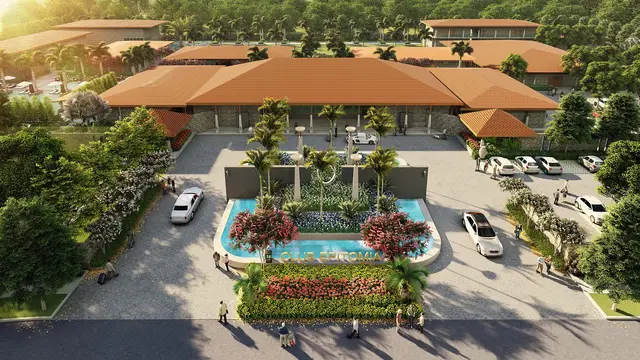
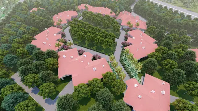
PRIME SQUARE 150 is a plotted development in THANGADIPALLY G.P AREA, Choutuppal Mandal, Yadadri Bhuvanagiri District, developed by the registered promoter SRI VENKATESHWARA INFRA & DEVELOPERS. The site totals 83,542.29 sq.m, with a net layout area of 82,197.80 sq.m, and the layout drawing schedule records 346 plots. Plot sizes shown in the drawing schedule range from 125.36 sq.m (149.9 sq.yd) to 322.54 sq.m (385.8 sq.yd). The project is registered with TG-RERA as P02000011368, and the promoter-declared completion date is 16/03/2029.
More from Sri Venkateshwara Infra And Developers · 5 projects →
01What we found
Read from TG-RERA filings, approvals, land and registration records and court records. A court case is counted only when the court record states this project's survey number with its village, or names the project.
02Check before you pay
8 items to check before you pay, 4 high - from the title chain, court records and approvals, each with what to ask the builder or your advocate. An item may not be a problem with the project: records can be incomplete.
1. Project at a glance
Project identity
| Item | Record |
|---|---|
| Registered project name | PRIME SQUARE 150 RERA record |
| Project type | Plotted development / open-plot layout RERA record RERA filing |
| Phase or registered portion | Not separately identified; the registration is for the project on Survey Nos. 722p, 723p, 724p and 725p. |
| TG-RERA registration | P02000011368 |
| Registration validity | 17/03/2026–16/03/2029; the certificate states registration was issued on 06/11/2026. This is the registration period, not a statement that the layout is complete. |
| Registered promoter | SRI VENKATESHWARA INFRA & DEVELOPERS, represented in the certificate by DAREDDY GOPAL REDDY and others |
| RERA status | Registered; the supplied certificate does not record an extension. |
Land and geographic identity
| Item | Record |
|---|---|
| Locality / village label in RERA record | THANGADIPALLY G.P AREA RERA record RERA filing |
| Revenue village stated in project documents | Thangadpally Village |
| Mandal | Choutuppal RERA record |
| District | Yadadri Bhuvanagiri RERA record |
| PIN | 508252 RERA record |
| Project survey numbers | 722p, 723p, 724p, 725p RERA record |
| Site area | 83,542.29 sq.m total; 1,344.49 sq.m is identified as road-affected area; 82,197.80 sq.m is the net layout area. RERA filing Layout record |
| Boundaries recorded | North: PROPOSED 150 WIDE MDP ROAD; South: EXISTING 33 PROPOSED 100 WIDE ROAD; East and West: NEIGHBOURS LAND. RERA filing |
Development identity
| Item | Record |
|---|---|
| Sanctioning authority stated in layout permission | Hyderabad Metropolitan Development Authority (HMDA); the permission is delegated to Choutuppal. |
| Layout permit / approval | 1872/HMDA/SWDL/2026, dated 17/03/2026 |
| Application / file number | 006456/HMDA/01943/SWDL/GTK/2025 |
| Approval stage in supplied permission | The document identifies itself as a draft layout / “LAYOUT WITH HOUSING - PERMISSION LETTER.” |
| Net layout area and land-use schedule | 82,197.8 sq.m net: plotted area 48,359.77 sq.m (58.83%); roads 24,985.56 sq.m (30.4%); open space 6,168.71 sq.m (7.5%); social infrastructure 2,057.54 sq.m (2.5%); utilities 626.23 sq.m (0.76%). |
| Building configuration / approved built-up area | Not applicable to the plotted-layout offering; no residential building floor configuration or approved built-up area is established in the supplied record. RERA filing |
| Layout plot count | The supplied RERA drawing schedule contains 346 plots; the draft permission separately lists mortgaged plot groups of 49 and 15 plots. Layout record |
Offering and status
| Item | Record |
|---|---|
| Offering | Plots; the vendor record describes a “plot 150 sq. yd.” configuration, while the layout drawing schedule records plot sizes from 125.36 sq.m (149.9 sq.yd) to 322.54 sq.m (385.8 sq.yd). The drawing-derived figures are software-read and should be checked against the drawing. Promoter website Layout record |
| Plot inventory | 346 plots, based on the layout drawing’s plot schedule. Booked and available counts are not supplied. Layout record |
| Construction stage | The RERA record includes a project registration and a draft layout permission. No independently verified site-progress assessment is supplied here. |
| Completion dates | Promoter-declared completion undertaking: 16/03/2029. The layout permission requires development works to be completed within THREE (3) YEARS; these are separate recorded timelines. |
| Occupancy / completion certificate | No occupancy or completion certificate is supplied. The project is a plotted layout; the available permission is identified as draft, not final-layout release. |
2. The project story
PRIME SQUARE 150 is registered with TG-RERA as a plotted development on land identified in the project record as Survey Nos. 722p, 723p, 724p and 725p, at THANGADIPALLY G.P AREA, Choutuppal Mandal, Yadadri Bhuvanagiri District. The layout-permission document calls the revenue location Thangadpally Village. The registered site totals 83,542.29 sq.m, with a stated net layout area of 82,197.80 sq.m after recording 1,344.49 sq.m as road-affected area. RERA record RERA filing
The offering is plots rather than apartments or completed houses. The layout drawing’s schedule records 346 plots; the supplied drawing-derived size range is 125.36–322.54 sq.m. These plot counts and sizes were extracted by software from the drawing and are not independent site measurements. The permission lists plots reserved under mortgages to HMDA and records conditions for development and later release of the final layout. Layout record
The TG-RERA certificate is valid through 16/03/2029, and the promoter’s Form B declares a completion date of 16/03/2029. The supplied evidence does not establish construction progress by independent inspection, final-layout release, or an occupancy/completion certificate.
3. Master plan, architecture & building design
This is a plotted layout, so the relevant design evidence is the plot schedule and land-use plan, not apartment floor plans or tower configuration. The layout drawing records 82,197.80 sq.m net layout area, allocated as follows: Layout record
| Layout use | Area | Share shown in record |
|---|---|---|
| Plotted area | 48,359.77 sq.m | 58.83% |
| Roads | 24,985.56 sq.m | 30.4% |
| Parks / open space | 6,168.71 sq.m | 7.5% |
| Social infrastructure | 2,057.54 sq.m | 2.5% |
| Utilities | 626.23 sq.m | 0.76% |
The draft layout permission identifies the plan as an open-plot layout and requires roads to be opened for access to neighbouring sites. It also lists cycling tracks, park development, avenue planting, storm-water drainage, street lighting, water-supply arrangements and other site infrastructure as development requirements or provisions. The permission states that plots are not to be built on before the final layout is issued.
No tower count, building footprint, apartment distribution, approved built-up area, building-floor configuration or building parking levels are established in the supplied evidence. The HMDA master-plan sheet is image-only and does not provide a survey-level land-use determination in the supplied record. RERA filing HMDA
4. Homes, configurations & floor plans
The project is offered as plots. The RERA filing includes an allotment-letter form, but its allottee, plot, booking amount and payment particulars are blank; it does not establish a buyer-specific allotment.
| Configuration | Units | Booked | Available | RERA saleable area | Measured carpet area | Loading (if supplied) |
|---|---|---|---|---|---|---|
| Plots | 346* | Not disclosed | Not disclosed | Not disclosed | Not applicable | Not supplied |
\*The count is read from the plot schedule on the layout drawing. Plot sizes read from that drawing range from 125.36 sq.m (149.9 sq.yd) to 322.54 sq.m (385.8 sq.yd); the median is 125.42 sq.m (150.0 sq.yd). These are software-measured drawing-extraction results, not RERA-filed saleable-area figures. Layout record
The land-use schedule assigns 48,359.77 sq.m to plots, 24,985.56 sq.m to roads, 6,168.71 sq.m to parks/open space, 2,057.54 sq.m to social infrastructure and 626.23 sq.m to utilities. Layout record
5. Parking & vehicle circulation
The supplied layout schedule records 0.0 sq.m as common parking area. No resident or visitor parking count, accessible-parking provision, plot-specific parking allocation, or parking-allotment arrangement is established in the available record. The draft permission identifies 64 plots in two HMDA mortgage groups—49 plots under Document No. 1155/2026 and 15 under Document No. 1130/2026—but these are mortgage-reserved plots, not evidence of parking spaces.
The layout permission refers to internal roads and states that roads are to be opened for access to neighbouring sites. The vendor record describes wide internal roads, but does not establish their delivery or a sanctioned parking arrangement. Promoter website
6. Amenities, recreation & open spaces
The layout permission and RERA amenity record describe site-level provisions. Percentages below are RERA-recorded progress entries, not independent verification of completion. RERA amenities
| Facility | Description / size | Evidence source | Declared progress / verified status |
|---|---|---|---|
| Parks / open space | 6,168.71 sq.m; park development is listed as a provision. | Layout record | RERA amenity entry shows 0% for green strip / park; no independent completion verification supplied. RERA amenities |
| Cycling track | Cycling tracks are listed as a layout requirement. | No completed status supplied. | |
| Avenue planting / landscape | Avenue plantation is listed in the permission. | No completed status supplied. | |
| Social infrastructure area | 2,057.54 sq.m | Area shown in the layout schedule; no facility-specific completion status supplied. | |
| Internal roads and footpaths | Roads occupy 24,985.56 sq.m in the land-use schedule. | Layout record | RERA amenity entry shows 30%; not independently verified. RERA amenities |
| Community building | No size or facility description supplied. | RERA amenities | No progress percentage supplied. |
| Vendor-described recreational / landscape features | “Cycling and jogging track” and “Landscaped garden” are marketing/vendor descriptions. | Promoter website | Not established as completed or independently verified. |
7. Utilities, building services & safety
The layout permission lists site utilities and services, but the supplied records do not provide capacities or independent completion verification.
| Evidence in the record | Permission calls for arrangements for potable/drinking-water supply and lists an overhead water tank; the vendor describes a planned water-supply network. Promoter website |
|---|---|
| Status / limitation | Water-supply amenity progress is shown as 0% in the RERA amenity record; no source, storage capacity or completed-service confirmation supplied. RERA amenities |
| Evidence in the record | Permission lists a common septic tank / STP; the RERA amenity list includes sewerage and treatment/disposal of sewage and sullage water. RERA amenities |
|---|---|
| Status / limitation | Sewerage progress is shown as 80%; treatment/disposal progress is 0%. These are recorded progress entries, not independent verification. RERA amenities |
| Evidence in the record | Permission requires underground storm-water drainage and lists rainwater-harvesting pits; the RERA amenity list includes storm-water drains and rainwater harvesting. RERA amenities |
|---|---|
| Status / limitation | Both corresponding amenity progress entries are 0%. RERA amenities |
| Evidence in the record | Permission lists a transformer/transformer yard and requires LED street lighting; the RERA amenity list includes an electrical meter room/sub-station/receiving station and street lighting. RERA amenities |
|---|---|
| Status / limitation | Progress entries are 0%; electrical capacity and completion status are not supplied. RERA amenities |
| Evidence in the record | Permission lists solid waste and a bio-compost unit. |
|---|---|
| Status / limitation | The RERA amenity entry for solid-waste management shows 0%. RERA amenities |
| Evidence in the record | RERA amenity categories include fire-protection requirements; no project-specific fire-system or accessibility details are supplied. RERA amenities |
|---|---|
| Status / limitation | No capacity, design, approval or completed status established. |
8. Location, access & connectivity
The registered project location is THANGADIPALLY G.P AREA, Choutuppal Mandal, Yadadri Bhuvanagiri District, Telangana, PIN 508252; the layout permission refers to Thangadpally Village. The recorded site boundaries include a proposed 150-wide MDP road to the north and an existing 33 / proposed 100-wide road to the south. RERA record RERA filing
A location record gives the cadastral parcel centroid as 18.8077171969499, 78.03059022908808. The supplied independent connectivity record lists the nearest sampled Outer Ring Road interchange at 139.3 km (approx.). Location record
Vendor-supplied connectivity claims—including distances to NH 65, the Outer Ring Road, Panthangi Toll Plaza and other destinations, as well as proposed transport corridors—are marketing/vendor statements and are not independently verified in the supplied project record. Promoter website
9. Developer & development status
The TG-RERA-registered promoter is SRI VENKATESHWARA INFRA & DEVELOPERS. The project filing identifies the organisation type as a partnership and provides GSTIN 36AEFFS3316G1Z5. The registration certificate lists the promoter office as Village: Jillelaguda, Mandal: Balapur, District: Ranga Reddy, Pin: 500097. RERA filing Corporate record
The RERA filing identifies DAREDDY GOPAL REDDY as authorized signatory and lists partners DAREDDY VIJAY KUMAR REDDY, SURVI JAGADISH GOUD, EDULLA SRIKANTH REDDY and VUNDYALA AYYAPA REDDY. The registration certificate names the promoter as represented by DAREDDY GOPAL REDDY and others. Parties record
The promoter’s Form B declares completion by 16/03/2029. No independent site inspection or verified construction-progress report is supplied in this overview’s evidence. The vendor’s description and possession timing are vendor statements, not RERA-established construction status. Promoter website
10. Approvals, official records & documents
| Identifier / date | P02000011368; issued 06/11/2026; valid 17/03/2026–16/03/2029 |
|---|---|
| What the supplied document establishes | Form C registers PRIME SQUARE 150 and lists the project survey numbers and registration conditions. |
| Identifier / date | 1872/HMDA/SWDL/2026, dated 17/03/2026 |
|---|---|
| What the supplied document establishes | Draft layout permission for an open-plot layout on Survey Nos. 722p, 723p, 724p and 725p; includes the land-use schedule, development conditions and mortgage-reserved plot groups. |
| Identifier / date | 006456/HMDA/01943/SWDL/GTK/2025 |
|---|---|
| What the supplied document establishes | Choutuppal Municipality document concerning HMDA draft-layout permission; identifies the site extent and layout conditions. |
| Identifier / date | Documents 1155/2026 and 1130/2026 |
|---|---|
| What the supplied document establishes | Permission lists 49 plots and 15 plots respectively as mortgage-reserved; it prohibits sale of mortgaged plots and sets out conditions for release. |
| Identifier / date | Document 1378/2026, dated 13.03.2026 |
|---|---|
| What the supplied document establishes | Permission records the road-affected area as handed over to the local body by registered gift deed. |
| Identifier / date | Filed by DAREDDY GOPAL REDDY as authorized signatory |
|---|---|
| What the supplied document establishes | Declares the promoter’s title and encumbrance position and completion undertaking; these are promoter declarations. |
| Identifier / date | Drawing document 766026 |
|---|---|
| What the supplied document establishes | A single layout sheet is recorded; plot count, plot sizes and land-use figures are drawing-derived and should be checked against the drawing. Layout record Document index |
No final-layout release or occupancy/completion certificate is supplied in the available evidence. The layout-permission document states that it is not proof of title.
1. Project at a glance
Project identity
Registered project name: PRIME SQUARE 150
Project type: Plotted development / open-plot layout
Phase or registered portion: Not separately identified; the registration is for the project on Survey Nos. 722p, 723p, 724p and 725p.
TG-RERA registration: P02000011368
Registration validity: 17/03/2026–16/03/2029; the certificate states registration was issued on 06/11/2026. This is the registration period, not a statement that the layout is complete.
Registered promoter: SRI VENKATESHWARA INFRA & DEVELOPERS, represented in the certificate by DAREDDY GOPAL REDDY and others
RERA status: Registered; the supplied certificate does not record an extension.
Land and geographic identity
Locality / village label in RERA record: THANGADIPALLY G.P AREA
Revenue village stated in project documents: Thangadpally Village
Mandal: Choutuppal
District: Yadadri Bhuvanagiri
PIN: 508252
Project survey numbers: 722p, 723p, 724p, 725p
Site area: 83,542.29 sq.m total; 1,344.49 sq.m is identified as road-affected area; 82,197.80 sq.m is the net layout area.
Boundaries recorded: North: PROPOSED 150 WIDE MDP ROAD; South: EXISTING 33 PROPOSED 100 WIDE ROAD; East and West: NEIGHBOURS LAND.
Development identity
Sanctioning authority stated in layout permission: Hyderabad Metropolitan Development Authority (HMDA); the permission is delegated to Choutuppal.
Layout permit / approval: 1872/HMDA/SWDL/2026, dated 17/03/2026
Application / file number: 006456/HMDA/01943/SWDL/GTK/2025
Approval stage in supplied permission: The document identifies itself as a draft layout / “LAYOUT WITH HOUSING - PERMISSION LETTER.”
Net layout area and land-use schedule: 82,197.8 sq.m net: plotted area 48,359.77 sq.m (58.83%); roads 24,985.56 sq.m (30.4%); open space 6,168.71 sq.m (7.5%); social infrastructure 2,057.54 sq.m (2.5%); utilities 626.23 sq.m (0.76%).
Building configuration / approved built-up area: Not applicable to the plotted-layout offering; no residential building floor configuration or approved built-up area is established in the supplied record.
Layout plot count: The supplied RERA drawing schedule contains 346 plots; the draft permission separately lists mortgaged plot groups of 49 and 15 plots.
Offering and status
Offering: Plots; the vendor record describes a “plot 150 sq. yd.” configuration, while the layout drawing schedule records plot sizes from 125.36 sq.m (149.9 sq.yd) to 322.54 sq.m (385.8 sq.yd). The drawing-derived figures are software-read and should be checked against the drawing.
Plot inventory: 346 plots, based on the layout drawing’s plot schedule. Booked and available counts are not supplied.
Construction stage: The RERA record includes a project registration and a draft layout permission. No independently verified site-progress assessment is supplied here.
Completion dates: Promoter-declared completion undertaking: 16/03/2029. The layout permission requires development works to be completed within THREE (3) YEARS; these are separate recorded timelines.
Occupancy / completion certificate: No occupancy or completion certificate is supplied. The project is a plotted layout; the available permission is identified as draft, not final-layout release.
2. The project story
PRIME SQUARE 150 is registered with TG-RERA as a plotted development on land identified in the project record as Survey Nos. 722p, 723p, 724p and 725p, at THANGADIPALLY G.P AREA, Choutuppal Mandal, Yadadri Bhuvanagiri District. The layout-permission document calls the revenue location Thangadpally Village. The registered site totals 83,542.29 sq.m, with a stated net layout area of 82,197.80 sq.m after recording 1,344.49 sq.m as road-affected area.
The offering is plots rather than apartments or completed houses. The layout drawing’s schedule records 346 plots; the supplied drawing-derived size range is 125.36–322.54 sq.m. These plot counts and sizes were extracted by software from the drawing and are not independent site measurements. The permission lists plots reserved under mortgages to HMDA and records conditions for development and later release of the final layout.
The TG-RERA certificate is valid through 16/03/2029, and the promoter’s Form B declares a completion date of 16/03/2029. The supplied evidence does not establish construction progress by independent inspection, final-layout release, or an occupancy/completion certificate.
3. Master plan, architecture & building design
This is a plotted layout, so the relevant design evidence is the plot schedule and land-use plan, not apartment floor plans or tower configuration. The layout drawing records 82,197.80 sq.m net layout area, allocated as follows:
| Layout use | Area | Share shown in record |
|---|---|---|
| Plotted area | 48,359.77 sq.m | 58.83% |
| Roads | 24,985.56 sq.m | 30.4% |
| Parks / open space | 6,168.71 sq.m | 7.5% |
| Social infrastructure | 2,057.54 sq.m | 2.5% |
| Utilities | 626.23 sq.m | 0.76% |
The draft layout permission identifies the plan as an open-plot layout and requires roads to be opened for access to neighbouring sites. It also lists cycling tracks, park development, avenue planting, storm-water drainage, street lighting, water-supply arrangements and other site infrastructure as development requirements or provisions. The permission states that plots are not to be built on before the final layout is issued.
No tower count, building footprint, apartment distribution, approved built-up area, building-floor configuration or building parking levels are established in the supplied evidence. The HMDA master-plan sheet is image-only and does not provide a survey-level land-use determination in the supplied record.
4. Homes, configurations & floor plans
The project is offered as plots. The RERA filing includes an allotment-letter form, but its allottee, plot, booking amount and payment particulars are blank; it does not establish a buyer-specific allotment.
| Configuration | Units | Booked | Available | RERA saleable area | Measured carpet area | Loading (if supplied) |
|---|---|---|---|---|---|---|
| Plots | 346* | Not disclosed | Not disclosed | Not disclosed | Not applicable | Not supplied |
\*The count is read from the plot schedule on the layout drawing. Plot sizes read from that drawing range from 125.36 sq.m (149.9 sq.yd) to 322.54 sq.m (385.8 sq.yd); the median is 125.42 sq.m (150.0 sq.yd). These are software-measured drawing-extraction results, not RERA-filed saleable-area figures.
The land-use schedule assigns 48,359.77 sq.m to plots, 24,985.56 sq.m to roads, 6,168.71 sq.m to parks/open space, 2,057.54 sq.m to social infrastructure and 626.23 sq.m to utilities.
5. Parking & vehicle circulation
The supplied layout schedule records 0.0 sq.m as common parking area. No resident or visitor parking count, accessible-parking provision, plot-specific parking allocation, or parking-allotment arrangement is established in the available record. The draft permission identifies 64 plots in two HMDA mortgage groups—49 plots under Document No. 1155/2026 and 15 under Document No. 1130/2026—but these are mortgage-reserved plots, not evidence of parking spaces.
The layout permission refers to internal roads and states that roads are to be opened for access to neighbouring sites. The vendor record describes wide internal roads, but does not establish their delivery or a sanctioned parking arrangement.
6. Amenities, recreation & open spaces
The layout permission and RERA amenity record describe site-level provisions. Percentages below are RERA-recorded progress entries, not independent verification of completion.
| Facility | Description / size | Evidence source | Declared progress / verified status |
|---|---|---|---|
| Parks / open space | 6,168.71 sq.m; park development is listed as a provision. | RERA amenity entry shows 0% for green strip / park; no independent completion verification supplied. | |
| Cycling track | Cycling tracks are listed as a layout requirement. | No completed status supplied. | |
| Avenue planting / landscape | Avenue plantation is listed in the permission. | No completed status supplied. | |
| Social infrastructure area | 2,057.54 sq.m | Area shown in the layout schedule; no facility-specific completion status supplied. | |
| Internal roads and footpaths | Roads occupy 24,985.56 sq.m in the land-use schedule. | RERA amenity entry shows 30%; not independently verified. | |
| Community building | No size or facility description supplied. | No progress percentage supplied. | |
| Vendor-described recreational / landscape features | “Cycling and jogging track” and “Landscaped garden” are marketing/vendor descriptions. | Not established as completed or independently verified. |
7. Utilities, building services & safety
The layout permission lists site utilities and services, but the supplied records do not provide capacities or independent completion verification.
| Evidence in the record | Permission calls for arrangements for potable/drinking-water supply and lists an overhead water tank; the vendor describes a planned water-supply network. |
|---|---|
| Status / limitation | Water-supply amenity progress is shown as 0% in the RERA amenity record; no source, storage capacity or completed-service confirmation supplied. |
| Evidence in the record | Permission lists a common septic tank / STP; the RERA amenity list includes sewerage and treatment/disposal of sewage and sullage water. |
|---|---|
| Status / limitation | Sewerage progress is shown as 80%; treatment/disposal progress is 0%. These are recorded progress entries, not independent verification. |
| Evidence in the record | Permission requires underground storm-water drainage and lists rainwater-harvesting pits; the RERA amenity list includes storm-water drains and rainwater harvesting. |
|---|---|
| Status / limitation | Both corresponding amenity progress entries are 0%. |
| Evidence in the record | Permission lists a transformer/transformer yard and requires LED street lighting; the RERA amenity list includes an electrical meter room/sub-station/receiving station and street lighting. |
|---|---|
| Status / limitation | Progress entries are 0%; electrical capacity and completion status are not supplied. |
| Evidence in the record | Permission lists solid waste and a bio-compost unit. |
|---|---|
| Status / limitation | The RERA amenity entry for solid-waste management shows 0%. |
| Evidence in the record | RERA amenity categories include fire-protection requirements; no project-specific fire-system or accessibility details are supplied. |
|---|---|
| Status / limitation | No capacity, design, approval or completed status established. |
8. Location, access & connectivity
The registered project location is THANGADIPALLY G.P AREA, Choutuppal Mandal, Yadadri Bhuvanagiri District, Telangana, PIN 508252; the layout permission refers to Thangadpally Village. The recorded site boundaries include a proposed 150-wide MDP road to the north and an existing 33 / proposed 100-wide road to the south.
A location record gives the cadastral parcel centroid as 18.8077171969499, 78.03059022908808. The supplied independent connectivity record lists the nearest sampled Outer Ring Road interchange at 139.3 km (approx.).
Vendor-supplied connectivity claims—including distances to NH 65, the Outer Ring Road, Panthangi Toll Plaza and other destinations, as well as proposed transport corridors—are marketing/vendor statements and are not independently verified in the supplied project record.
9. Developer & development status
The TG-RERA-registered promoter is SRI VENKATESHWARA INFRA & DEVELOPERS. The project filing identifies the organisation type as a partnership and provides GSTIN 36AEFFS3316G1Z5. The registration certificate lists the promoter office as Village: Jillelaguda, Mandal: Balapur, District: Ranga Reddy, Pin: 500097.
The RERA filing identifies DAREDDY GOPAL REDDY as authorized signatory and lists partners DAREDDY VIJAY KUMAR REDDY, SURVI JAGADISH GOUD, EDULLA SRIKANTH REDDY and VUNDYALA AYYAPA REDDY. The registration certificate names the promoter as represented by DAREDDY GOPAL REDDY and others.
The promoter’s Form B declares completion by 16/03/2029. No independent site inspection or verified construction-progress report is supplied in this overview’s evidence. The vendor’s description and possession timing are vendor statements, not RERA-established construction status.
10. Approvals, official records & documents
| Identifier / date | P02000011368; issued 06/11/2026; valid 17/03/2026–16/03/2029 |
|---|---|
| What the supplied document establishes | Form C registers PRIME SQUARE 150 and lists the project survey numbers and registration conditions. |
| Identifier / date | 1872/HMDA/SWDL/2026, dated 17/03/2026 |
|---|---|
| What the supplied document establishes | Draft layout permission for an open-plot layout on Survey Nos. 722p, 723p, 724p and 725p; includes the land-use schedule, development conditions and mortgage-reserved plot groups. |
| Identifier / date | 006456/HMDA/01943/SWDL/GTK/2025 |
|---|---|
| What the supplied document establishes | Choutuppal Municipality document concerning HMDA draft-layout permission; identifies the site extent and layout conditions. |
| Identifier / date | Documents 1155/2026 and 1130/2026 |
|---|---|
| What the supplied document establishes | Permission lists 49 plots and 15 plots respectively as mortgage-reserved; it prohibits sale of mortgaged plots and sets out conditions for release. |
| Identifier / date | Document 1378/2026, dated 13.03.2026 |
|---|---|
| What the supplied document establishes | Permission records the road-affected area as handed over to the local body by registered gift deed. |
| Identifier / date | Filed by DAREDDY GOPAL REDDY as authorized signatory |
|---|---|
| What the supplied document establishes | Declares the promoter’s title and encumbrance position and completion undertaking; these are promoter declarations. |
| Identifier / date | Drawing document 766026 |
|---|---|
| What the supplied document establishes | A single layout sheet is recorded; plot count, plot sizes and land-use figures are drawing-derived and should be checked against the drawing. |
No final-layout release or occupancy/completion certificate is supplied in the available evidence. The layout-permission document states that it is not proof of title.
Frequently asked questions
Is PRIME SQUARE 150 registered with Telangana RERA?
Yes. PRIME SQUARE 150 is registered with the Telangana Real Estate Regulatory Authority as P02000011368; the registration status is New Project.
Who is the developer of PRIME SQUARE 150?
The promoter named in the RERA registration is SRI VENKATESHWARA INFRA & DEVELOPERS.
Where is PRIME SQUARE 150 located?
PRIME SQUARE 150 is in CHOUTUPPAL MANDAL, THANGADIPALLY G.P AREA, Choutuppal, Yadadri Bhuvanagiri, Telangana (508252).
When will PRIME SQUARE 150 be completed?
The promoter's proposed date of completion filed with RERA is 16/03/2029. This is the promoter's declaration, not a guarantee.
More projects in Thangadipally G P Area