Sri Nilayam Bloom
SLNS I DEVELOPERS · Rangareddy · RERA P02400003030
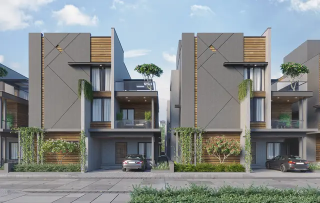
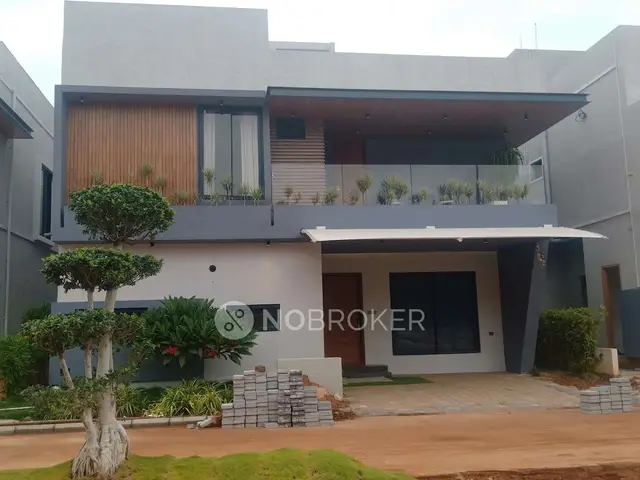
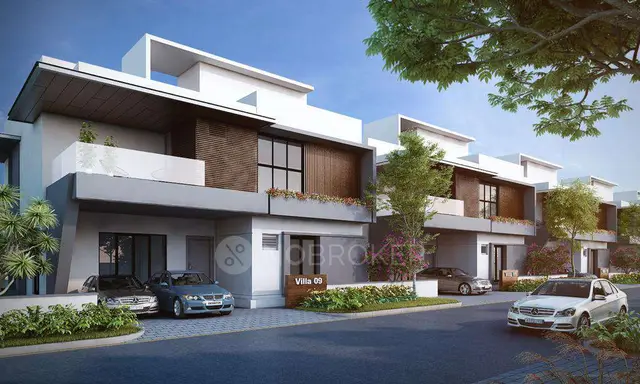
SRI NILAYAM BLOOM is a residential villa development at Manneguda, Abdullapurmet Mandal, Ranga Reddy District, developed by the registered promoter SLNS I DEVELOPERS. The TG-RERA land record states a total area of 32,159 sqmts and net area of 21,236.00 sqmts; it records 49 total/proposed building units, while the filed layout drawing records 50 in its “Grand Total.” Residential buildings are Ground + 1 upper floors, and the project’s TG-RERA registration number is P02400003030, valid through 31/03/2023, the stated proposed completion date.
01What we found
Read from TG-RERA filings, approvals, land and registration records and court records. A court case is counted only when the court record states this project's survey number with its village, or names the project.
02Check before you pay
11 items to check before you pay, 5 high - from the title chain, court records and approvals, each with what to ask the builder or your advocate. An item may not be a problem with the project: records can be incomplete.
1. Project at a glance
Project identity
| Field | Record |
|---|---|
| Registered project name | SRI NILAYAM BLOOM RERA record |
| Project type | Residential villa development; the filed plan describes a layout with housing under a gated community. RERA record |
| Phase / registered portion | Phase not separately identified in the available record. TG-RERA registration is P02400003030. RERA record |
| Registered promoter | SLNS I DEVELOPERS; the registration certificate names the promoter as “Slns I Developers.” RERA record |
| TG-RERA validity | 17/06/2021–31/03/2023. The supplied registration record says it was not extended; current registration status beyond the recorded end date is not established by the material provided. RERA record |
Land and geographic identity
| Field | Record |
|---|---|
| Locality | Manneguda; the filed plans identify Turkayamjal. RERA record RERA filing |
| Revenue village | Manneguda is recorded in the project identity; the filed layout and municipal release identify Turkayamjal Village. RERA record RERA filing |
| Mandal | Abdullapurmet; the approval record also refers to Turkayamjal Municipality Mandal. RERA record |
| District / PIN | Ranga Reddy / 501510. RERA record |
| Project survey number | 490/P. RERA record Land records |
| Site areas | TG-RERA land record: total 32,159 sqmts, affected area 10,923 sqmts, net area 21,236.00 sqmts. The filed drawing states total 32159.84 sq.m., net 21236.27 sq.m., and “Leftover Owners Land Area” 10923.57 sq.m. RERA filing |
| Boundaries | North: ROAD; South: LAND OF B SWEETHA AND OTHER; East: PASSAGE TO NEIGHBOURS LAND; West: LAND OF JALAGAM VENKAT RAO. RERA filing |
Development identity
| Field | Record |
|---|---|
| Sanctioning authority and principal approval | HMDA technical layout approval, Layout Permit No. 000051/LO/Plg/HMDA/2021, dated 21 January 2021; Turkayamjal Municipality final-layout release G1/07/TPS/TMC/2021/Layout, dated 28/01/2021. Approvals record |
| Approved built-up area | The supplied RERA filing records 15,000 sqmts as approved built-up area. The drawing extraction does not identify a single corresponding approved built-up-area figure in a way that establishes it as the same measure. RERA filing |
| Layout / building scale | The filed layout drawing records 50 in its “Grand Total” and building groups with ground-plus-one-upper-floor configurations; the TG-RERA land form records 49 total/proposed building units. The drawing extraction also identifies a proposed clubhouse. RERA filing |
| Floor configuration | The extracted plan shows residential buildings as Ground + 1 upper floors (also described in parts of the drawing as Ground Floor, First Floor, Terrace Floor) and the clubhouse as Ground + 2 upper floors. No basement, stilt, podium or parking-level configuration is established in the supplied material. |
| Parking | No project-wide parking count or allocation schedule is established in the supplied material. |
Offering and status
| Field | Record |
|---|---|
| Unit type on TG-RERA record | VILLA. RERA unit table RERA unit details |
| RERA-filed counts | The filed unit record lists 0 units, 0 booked and 0 available for VILLA; these are the counts in the supplied portal extraction, whose booking record has no as-of date. RERA unit table RERA unit details |
| Plot layout | The software-measured drawing extraction identifies at least 49 plots; the plotted area is 11420.21 sq.m. Plot-list extraction is incomplete. Layout record |
| Construction stage | The available material does not establish independently verified current construction progress or completion. RERA record RERA amenities |
| Completion deadline | The promoter’s Form B declaration gives 31/03/2023 as the undertaking date; the TG-RERA registration validity also ends on that date. This is separate from registration validity and does not establish completion. RERA record |
| Occupancy / completion certificate | No occupancy or completion certificate is established in the supplied documents. Its status and applicable building/tower scope are not confirmed. Document index |
2. The project story
SRI NILAYAM BLOOM is recorded as a residential villa project on Survey No. 490/P, at Manneguda, with the filed layout material identifying Turkayamjal Village in Abdullapurmet Mandal, Ranga Reddy District. The HMDA plan describes a gated-community layout with residential buildings on plots and a clubhouse; the local municipality’s record describes a final layout with open plots and houses. The layout drawing extraction lists at least 49 plots, while the TG-RERA land form states 49 total and proposed building units. The drawing’s plot list is incomplete, so the extracted plot count is a minimum rather than a complete plot schedule. The available record does not establish which individual villas or common facilities have been built, whether any portions are complete, or whether an occupancy/completion certificate has been issued. RERA record RERA filing RERA filing Layout record Document index
3. Master plan, architecture & building design
The filed HMDA drawing records a total site area of 32159.84 sq.m. and net site area of 21236.27 sq.m., with 10923.57 sq.m. described as “Leftover Owners Land Area.” Its stated land-use components are plotted area 11420.21 sq.m., road area 5861.19 sq.m., organized open space/park/utility area 2905.78 sq.m., and mortgage area 627.00 sq.m.
The drawing describes residential buildings on plot groups, predominantly Ground + 1 upper floors, and a clubhouse at Ground + 2 upper floors. The supplied extraction does not establish individual building footprints, villa-by-villa floor areas, room layouts, or a complete building schedule. It also does not establish basement, stilt, podium or other parking floors.
The drawing identifies 30.00, 12.80M and 9.14M road widths, an existing 80' wide road, and a proposed 150' wide master plan road. These are plan labels, not confirmation of present road delivery or access conditions.
4. Homes, configurations & floor plans
| Configuration | Units | Booked | Available | RERA saleable area | Measured carpet area | Loading (if supplied) |
|---|---|---|---|---|---|---|
| Villa (filed as “VILLA”) | 0 | 0 | 0 | Not established in the supplied extraction | Not measured | Not supplied |
Unit counts and booking fields above are from the supplied TG-RERA unit record, which has no as-of date. The available drawing analysis contains two layout sheets and no measured home floor plans; consequently, no software-measured carpet area, room dimensions or villa-specific floor arrangement is available. RERA unit table RERA unit details Floor plans
The drawing extraction identifies at least 49 plots and four plot-size bands: 200–250 sq yd: 27 plots; 250–300 sq yd: 16; 300–400 sq yd: 1; 400–500 sq yd: 3. The extracted smallest, median and largest plot sizes are 209.03 sq.m., 209.03 sq.m. and 391.31 sq.m. respectively. These are software-measured from the filed drawing, and the plot list is incomplete. Layout record
5. Parking & vehicle circulation
The supplied project record does not establish a total number of resident or visitor parking spaces, accessible spaces, parking levels, EV charging, or unit-specific parking allocations. The drawing identifies plots 38, 41 and 42 as mortgaged to HMDA; that is an approval-related plot reservation, not evidence of buyer parking allocation.
The filed plan shows internal roads with labelled widths, but the supplied material does not document vehicle-entry or exit arrangements, ramps, pedestrian separation, or the current condition of the internal driveways.
6. Amenities, recreation & open spaces
| Description / size | Drawing identifies a proposed clubhouse, Ground + 2 upper floors; no area or capacity supplied. |
|---|---|
| Evidence source | Filed HMDA drawing |
| Declared progress / verified status | Proposed on drawing; completion not established. |
| Description / size | 2905.78 sq.m. in the layout drawing; the HMDA draft-layout extraction separately lists open space 1050.04 and park 2905.78. |
|---|---|
| Evidence source | Filed layout drawing and HMDA draft-layout extraction |
| Declared progress / verified status | Planned provision; delivery not established. |
| Description / size | RERA amenity record marks “Internal Roads & Footpaths” available; drawing lists road area 5861.19 sq.m. |
|---|---|
| Evidence source | RERA amenity record RERA amenities; filed layout drawing |
| Declared progress / verified status | Recorded as available in the filing; independent completion verification not supplied. |
| Description / size | RERA amenity record marks this facility available. |
|---|---|
| Evidence source | RERA amenity record RERA amenities |
| Declared progress / verified status | Filing status only; independent completion verification not supplied. |
| Description / size | RERA amenity record marks community buildings available. |
|---|---|
| Evidence source | RERA amenity record RERA amenities |
| Declared progress / verified status | Filing status only; no specific buildings or completion evidence supplied. |
The vendor material also lists a swimming pool, gym, children’s play area and clubhouse, but these are third-party marketing details rather than established delivery evidence in the supplied TG-RERA documents. Promoter website
7. Utilities, building services & safety
The filed HMDA draft-layout conditions call for street lighting and electricity facilities, a protected water supply with OHT and sumps, an independent sewerage-disposal system, underground ducting of utilities, greenery and park development. The extraction also lists a common septic tank/STP, transformer and rainwater-harvesting pits among the planned services. These are plan conditions or listed provisions; the supplied material does not verify their installation, capacity or operation.
The TG-RERA amenity record marks water supply, sewerage, storm-water drains, street lighting, water conservation/rainwater harvesting and electrical meter room/sub-station/receiving station as available in the filing. It does not provide service capacities or independent completion evidence. Fire protection, solid-waste management and energy-management fields appear in the RERA amenity list without a supplied progress value. RERA amenities
No verified details are supplied for water source or storage capacity, sewage-treatment capacity or reuse, power-backup capacity, lifts, CCTV/access-control installation, fire equipment or clearances, or accessible circulation. Vendor listings mention power backup, security, CCTV and fire safety, but those are not confirmation of installed or approved project services. Promoter website
8. Location, access & connectivity
The project identity records Manneguda, Abdullapurmet Mandal, Ranga Reddy District, Telangana 501510; the filed layout records Turkayamjal Village. The drawing labels an existing 80' wide road, a proposed 150' wide master plan road, and internal roads of 30.00, 12.80M and 9.14M. The supplied material does not verify current road delivery or public-transport service at the site. RERA record RERA filing
The supplied location extraction gives these measured distances: Financial District (Nanakramguda) 1.2 km; IndusInd Bank 0.4 km; unnamed bus station 2.2 km; Manuu Polytechnic Hyderabad 1.6 km; Sankaraya Eye Hospital 1.6 km; ADP 0.0 km; South India Shopping Mall 2.6 km; unnamed park 1.2 km; Nanakramguda Government Primary School 0.5 km. These are location-data distances; no travel times are supplied. Location record
9. Developer & development status
The registered promoter is SLNS I DEVELOPERS, recorded as a partnership. The named partners are PULKANLU BHUPATHI REDDY, SAMA YADHAGIRI GOUD and SAMA NAGARAJU GOUD; KOLANU KALINGA REDDY is identified as authorized signatory. The supplied registration certificate gives the promoter office as Village: Hanumanagar, Mandal: Saroornagar, District: Ranga Reddy, Pin: 500079; the project record separately gives an address at Manneguda, Abdullapurmet. No official promoter website or contact details are supplied. The promoter’s Form B declaration undertakes completion by 31/03/2023; the registration certificate records validity through the same date. The supplied material does not establish an extension, current construction progress, project completion, or an occupancy/completion certificate. Corporate record Parties record
10. Approvals, official records & documents
| Identifier / date | P02400003030; issued 17/06/2021, valid through 31/03/2023 |
|---|---|
| What the supplied document establishes | Form C registration for SRI NILAYAM BLOOM and stated registration conditions. |
| Identifier / date | 000051/LO/Plg/HMDA/2021; 21 January 2021 |
|---|---|
| What the supplied document establishes | Draft gated-community layout for Survey No. 490/P; technical approval forwarded to the local body for final sanction. |
| Identifier / date | G1/07/TPS/TMC/2021/Layout; 28/01/2021 |
|---|---|
| What the supplied document establishes | Final-layout release for Survey No. 490/P, identifying open plots and houses and referencing the HMDA layout permit. |
| Identifier / date | Layout Permit No. 000051/LO/Plg/HMDA/2021 |
|---|---|
| What the supplied document establishes | Drawing extraction includes site areas, plot/road/open-space figures, building groups, clubhouse and reserved mortgage plots. |
| Identifier / date | Form B, dated as extracted “08rH”; completion undertaking states 3Uo3lzo23 |
|---|---|
| What the supplied document establishes | Promoter declaration concerning title basis, encumbrance disclosure, separate account and completion undertaking; the date text is OCR-truncated. |
| Identifier / date | Not established in supplied documents |
|---|---|
| What the supplied document establishes | No such certificate is identified in the reviewed project material. Document index |
1. Project at a glance
Project identity
Registered project name: SRI NILAYAM BLOOM
Project type: Residential villa development; the filed plan describes a layout with housing under a gated community.
Phase / registered portion: Phase not separately identified in the available record. TG-RERA registration is P02400003030.
Registered promoter: SLNS I DEVELOPERS; the registration certificate names the promoter as “Slns I Developers.”
TG-RERA validity: 17/06/2021–31/03/2023. The supplied registration record says it was not extended; current registration status beyond the recorded end date is not established by the material provided.
Land and geographic identity
Locality: Manneguda; the filed plans identify Turkayamjal.
Revenue village: Manneguda is recorded in the project identity; the filed layout and municipal release identify Turkayamjal Village.
Mandal: Abdullapurmet; the approval record also refers to Turkayamjal Municipality Mandal.
District / PIN: Ranga Reddy / 501510.
Project survey number: 490/P.
Site areas: TG-RERA land record: total 32,159 sqmts, affected area 10,923 sqmts, net area 21,236.00 sqmts. The filed drawing states total 32159.84 sq.m., net 21236.27 sq.m., and “Leftover Owners Land Area” 10923.57 sq.m.
Boundaries: North: ROAD; South: LAND OF B SWEETHA AND OTHER; East: PASSAGE TO NEIGHBOURS LAND; West: LAND OF JALAGAM VENKAT RAO.
Development identity
Sanctioning authority and principal approval: HMDA technical layout approval, Layout Permit No. 000051/LO/Plg/HMDA/2021, dated 21 January 2021; Turkayamjal Municipality final-layout release G1/07/TPS/TMC/2021/Layout, dated 28/01/2021.
Approved built-up area: The supplied RERA filing records 15,000 sqmts as approved built-up area. The drawing extraction does not identify a single corresponding approved built-up-area figure in a way that establishes it as the same measure.
Layout / building scale: The filed layout drawing records 50 in its “Grand Total” and building groups with ground-plus-one-upper-floor configurations; the TG-RERA land form records 49 total/proposed building units. The drawing extraction also identifies a proposed clubhouse.
Floor configuration: The extracted plan shows residential buildings as Ground + 1 upper floors (also described in parts of the drawing as Ground Floor, First Floor, Terrace Floor) and the clubhouse as Ground + 2 upper floors. No basement, stilt, podium or parking-level configuration is established in the supplied material.
Parking: No project-wide parking count or allocation schedule is established in the supplied material.
Offering and status
Unit type on TG-RERA record: VILLA.
RERA-filed counts: The filed unit record lists 0 units, 0 booked and 0 available for VILLA; these are the counts in the supplied portal extraction, whose booking record has no as-of date.
Plot layout: The software-measured drawing extraction identifies at least 49 plots; the plotted area is 11420.21 sq.m. Plot-list extraction is incomplete.
Construction stage: The available material does not establish independently verified current construction progress or completion.
Completion deadline: The promoter’s Form B declaration gives 31/03/2023 as the undertaking date; the TG-RERA registration validity also ends on that date. This is separate from registration validity and does not establish completion.
Occupancy / completion certificate: No occupancy or completion certificate is established in the supplied documents. Its status and applicable building/tower scope are not confirmed.
2. The project story
SRI NILAYAM BLOOM is recorded as a residential villa project on Survey No. 490/P, at Manneguda, with the filed layout material identifying Turkayamjal Village in Abdullapurmet Mandal, Ranga Reddy District. The HMDA plan describes a gated-community layout with residential buildings on plots and a clubhouse; the local municipality’s record describes a final layout with open plots and houses. The layout drawing extraction lists at least 49 plots, while the TG-RERA land form states 49 total and proposed building units. The drawing’s plot list is incomplete, so the extracted plot count is a minimum rather than a complete plot schedule. The available record does not establish which individual villas or common facilities have been built, whether any portions are complete, or whether an occupancy/completion certificate has been issued.
3. Master plan, architecture & building design
The filed HMDA drawing records a total site area of 32159.84 sq.m. and net site area of 21236.27 sq.m., with 10923.57 sq.m. described as “Leftover Owners Land Area.” Its stated land-use components are plotted area 11420.21 sq.m., road area 5861.19 sq.m., organized open space/park/utility area 2905.78 sq.m., and mortgage area 627.00 sq.m.
The drawing describes residential buildings on plot groups, predominantly Ground + 1 upper floors, and a clubhouse at Ground + 2 upper floors. The supplied extraction does not establish individual building footprints, villa-by-villa floor areas, room layouts, or a complete building schedule. It also does not establish basement, stilt, podium or other parking floors.
The drawing identifies 30.00, 12.80M and 9.14M road widths, an existing 80' wide road, and a proposed 150' wide master plan road. These are plan labels, not confirmation of present road delivery or access conditions.
4. Homes, configurations & floor plans
| Configuration | Units | Booked | Available | RERA saleable area | Measured carpet area | Loading (if supplied) |
|---|---|---|---|---|---|---|
| Villa (filed as “VILLA”) | 0 | 0 | 0 | Not established in the supplied extraction | Not measured | Not supplied |
Unit counts and booking fields above are from the supplied TG-RERA unit record, which has no as-of date. The available drawing analysis contains two layout sheets and no measured home floor plans; consequently, no software-measured carpet area, room dimensions or villa-specific floor arrangement is available.
The drawing extraction identifies at least 49 plots and four plot-size bands: 200–250 sq yd: 27 plots; 250–300 sq yd: 16; 300–400 sq yd: 1; 400–500 sq yd: 3. The extracted smallest, median and largest plot sizes are 209.03 sq.m., 209.03 sq.m. and 391.31 sq.m. respectively. These are software-measured from the filed drawing, and the plot list is incomplete.
5. Parking & vehicle circulation
The supplied project record does not establish a total number of resident or visitor parking spaces, accessible spaces, parking levels, EV charging, or unit-specific parking allocations. The drawing identifies plots 38, 41 and 42 as mortgaged to HMDA; that is an approval-related plot reservation, not evidence of buyer parking allocation.
The filed plan shows internal roads with labelled widths, but the supplied material does not document vehicle-entry or exit arrangements, ramps, pedestrian separation, or the current condition of the internal driveways.
6. Amenities, recreation & open spaces
| Description / size | Drawing identifies a proposed clubhouse, Ground + 2 upper floors; no area or capacity supplied. |
|---|---|
| Evidence source | Filed HMDA drawing |
| Declared progress / verified status | Proposed on drawing; completion not established. |
| Description / size | 2905.78 sq.m. in the layout drawing; the HMDA draft-layout extraction separately lists open space 1050.04 and park 2905.78. |
|---|---|
| Evidence source | Filed layout drawing and HMDA draft-layout extraction |
| Declared progress / verified status | Planned provision; delivery not established. |
| Description / size | RERA amenity record marks “Internal Roads & Footpaths” available; drawing lists road area 5861.19 sq.m. |
|---|---|
| Evidence source | RERA amenity record; filed layout drawing |
| Declared progress / verified status | Recorded as available in the filing; independent completion verification not supplied. |
| Description / size | RERA amenity record marks this facility available. |
|---|---|
| Evidence source | RERA amenity record |
| Declared progress / verified status | Filing status only; independent completion verification not supplied. |
| Description / size | RERA amenity record marks community buildings available. |
|---|---|
| Evidence source | RERA amenity record |
| Declared progress / verified status | Filing status only; no specific buildings or completion evidence supplied. |
The vendor material also lists a swimming pool, gym, children’s play area and clubhouse, but these are third-party marketing details rather than established delivery evidence in the supplied TG-RERA documents.
7. Utilities, building services & safety
The filed HMDA draft-layout conditions call for street lighting and electricity facilities, a protected water supply with OHT and sumps, an independent sewerage-disposal system, underground ducting of utilities, greenery and park development. The extraction also lists a common septic tank/STP, transformer and rainwater-harvesting pits among the planned services. These are plan conditions or listed provisions; the supplied material does not verify their installation, capacity or operation.
The TG-RERA amenity record marks water supply, sewerage, storm-water drains, street lighting, water conservation/rainwater harvesting and electrical meter room/sub-station/receiving station as available in the filing. It does not provide service capacities or independent completion evidence. Fire protection, solid-waste management and energy-management fields appear in the RERA amenity list without a supplied progress value.
No verified details are supplied for water source or storage capacity, sewage-treatment capacity or reuse, power-backup capacity, lifts, CCTV/access-control installation, fire equipment or clearances, or accessible circulation. Vendor listings mention power backup, security, CCTV and fire safety, but those are not confirmation of installed or approved project services.
8. Location, access & connectivity
The project identity records Manneguda, Abdullapurmet Mandal, Ranga Reddy District, Telangana 501510; the filed layout records Turkayamjal Village. The drawing labels an existing 80' wide road, a proposed 150' wide master plan road, and internal roads of 30.00, 12.80M and 9.14M. The supplied material does not verify current road delivery or public-transport service at the site.
The supplied location extraction gives these measured distances: Financial District (Nanakramguda) 1.2 km; IndusInd Bank 0.4 km; unnamed bus station 2.2 km; Manuu Polytechnic Hyderabad 1.6 km; Sankaraya Eye Hospital 1.6 km; ADP 0.0 km; South India Shopping Mall 2.6 km; unnamed park 1.2 km; Nanakramguda Government Primary School 0.5 km. These are location-data distances; no travel times are supplied.
9. Developer & development status
The registered promoter is SLNS I DEVELOPERS, recorded as a partnership. The named partners are PULKANLU BHUPATHI REDDY, SAMA YADHAGIRI GOUD and SAMA NAGARAJU GOUD; KOLANU KALINGA REDDY is identified as authorized signatory. The supplied registration certificate gives the promoter office as Village: Hanumanagar, Mandal: Saroornagar, District: Ranga Reddy, Pin: 500079; the project record separately gives an address at Manneguda, Abdullapurmet. No official promoter website or contact details are supplied. The promoter’s Form B declaration undertakes completion by 31/03/2023; the registration certificate records validity through the same date. The supplied material does not establish an extension, current construction progress, project completion, or an occupancy/completion certificate.
10. Approvals, official records & documents
| Identifier / date | P02400003030; issued 17/06/2021, valid through 31/03/2023 |
|---|---|
| What the supplied document establishes | Form C registration for SRI NILAYAM BLOOM and stated registration conditions. |
| Identifier / date | 000051/LO/Plg/HMDA/2021; 21 January 2021 |
|---|---|
| What the supplied document establishes | Draft gated-community layout for Survey No. 490/P; technical approval forwarded to the local body for final sanction. |
| Identifier / date | G1/07/TPS/TMC/2021/Layout; 28/01/2021 |
|---|---|
| What the supplied document establishes | Final-layout release for Survey No. 490/P, identifying open plots and houses and referencing the HMDA layout permit. |
| Identifier / date | Layout Permit No. 000051/LO/Plg/HMDA/2021 |
|---|---|
| What the supplied document establishes | Drawing extraction includes site areas, plot/road/open-space figures, building groups, clubhouse and reserved mortgage plots. |
| Identifier / date | Form B, dated as extracted “08rH”; completion undertaking states 3Uo3lzo23 |
|---|---|
| What the supplied document establishes | Promoter declaration concerning title basis, encumbrance disclosure, separate account and completion undertaking; the date text is OCR-truncated. |
| Identifier / date | Not established in supplied documents |
|---|---|
| What the supplied document establishes | No such certificate is identified in the reviewed project material. |
Frequently asked questions
Is SRI NILAYAM BLOOM registered with Telangana RERA?
Yes. SRI NILAYAM BLOOM is registered with the Telangana Real Estate Regulatory Authority as P02400003030; the registration status is New Project.
Who is the developer of SRI NILAYAM BLOOM?
The promoter named in the RERA registration is SLNS I DEVELOPERS.
Where is SRI NILAYAM BLOOM located?
SRI NILAYAM BLOOM is in MANNEGUDA, Abdullapurmet, Rangareddy, Telangana (501510).
When will SRI NILAYAM BLOOM be completed?
The promoter's proposed date of completion filed with RERA is 31/03/2023. This is the promoter's declaration, not a guarantee.
More projects in Manneguda