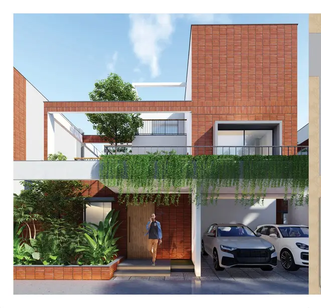
Shubadha County
SHUBHADA INFRA · Hanamkonda · RERA P00300009926
SHUBADHA COUNTY is a residential project in HANAMKONDA, Khazipet, Warangal Urban, developed by the registered promoter SHUBHADA INFRA. The project covers 12,130.13 sq.m and is a gated group-development scheme with 35 villas and 2 club-house buildings, each shown as Ground + 2 upper floors. The villas are residential homes, and the TG-RERA-filed saleable area ranges from 85.43 to 132.56 sq.m. It is registered under TG-RERA number P00300009926, and the promoter’s declared completion date is 03/04/2030.
01What we found
Read from TG-RERA filings, approvals, land and registration records and court records. A court case is counted only when the court record states this project's survey number with its village, or names the project.
02Check before you pay
12 items to check before you pay, 3 high - from the title chain, court records and approvals, each with what to ask the builder or your advocate. An item may not be a problem with the project: records can be incomplete.
1. Project at a glance
Project identity
| Item | Project record |
|---|---|
| Registered project name | SHUBADHA COUNTY RERA record |
| Project type | TG-RERA records it as a residential project; the filed plan describes a gated group-development scheme with villas. RERA record RERA filing |
| Phase / registered portion | No separate phase name is stated. The registration covers the project land identified below. |
| TG-RERA registration | P00300009926; valid 03/04/2025–03/04/2030, subject to the Act, Rules and certificate conditions. This is the registration validity period, not the completion deadline. RERA record |
| Registered promoter | SHUBHADA INFRA; registered as a partnership. RERA record Corporate record |
| RERA status | The supplied certificate records the project as registered. |
Land and geographic identity
| Item | Project record |
|---|---|
| Locality | HANAMKONDA RERA record RERA filing |
| Revenue village | Shayampet is the village in the TG-RERA registration. The filed layout drawing identifies the land as Kazipet Jagir Revenue Village. |
| Mandal / district / PIN | Khazipet / Warangal Urban / 506001 in the TG-RERA identity record. The layout drawing separately states KAZIPET(M) and HANAMKONDA(D). RERA record |
| Survey numbers and subdivisions | 169/B9/1, 169/B6/1, 169/B7/1, 169/B8/1, 165/C/1(NEW), 165/C(OLD), 91/C(OLD TO OLD), 169(NEW), 90(OLD). |
| Registered site area | TG-RERA land details state total area 12,130.13 sq.m, affected area 192.86 sq.m, and net area 11,937.27 sq.m. RERA filing |
| Filed layout area statement | The drawing states total layout area 12,130.13 sq.mt. and net layout area 11,937.31 sq.mt. |
| Boundaries in the RERA land record | North: ROAD; south, east and west: OTHER PLOTS. RERA filing |
Development identity
| Item | Project record |
|---|---|
| Sanctioning authority / principal approval | The filed plan identifies TS-DTCP and file no. TS/004305/2025. The project approval record also includes GWMC’s APPROVAL FOR GROUP DEVELOPMENT SCHEME, application no. 009197/LO/GWMC/3006/0235/2024, approved 04/03/2025 7:18:30 PM. |
| Plan / permission identifiers | 009197/LO/GWMC/3006/0235/2024; the approval document also lists building permission number 000591/BP/DTCP/3085/0001/2021. Approvals record |
| Approved built-up area | The GWMC approval extraction states Total Built up Area 14444.52 sq.m. The filed layout-plan extraction separately gives proposed built-up figures; see the design section. |
| Development form and building count | The layout drawing describes a gated group-development scheme; the TG-RERA record lists 37 total approved building units. The drawing identifies 35 villas and 2 club-house buildings. RERA filing |
| Sanctioned floor configuration | Ground + 2 upper floors; the GWMC approval says not to construct more than 1 Ground + 2 upper floors and states height 9.99 m. |
| Parking | The filed layout-plan extraction states proposed parking area 663.34 sq.m, required parking area 189.13 sq.m, and 3 proposed cars. A common parking area is recorded as 0.00 sq.m in its land-use table. |
| Unit counts | The approval extraction states 37 dwelling units; the layout drawing states 37 individual sub-plots and 35 units. The TG-RERA land record gives 37 total building units. RERA filing |
Offering and status
| Item | Project record |
|---|---|
| Unit type | Villas / residential homes; the registration’s unit table is filed by floor labels rather than a named home configuration. RERA record RERA unit details |
| RERA-filed count and saleable-area range | 114 entries filed as floor labels, with 0 booked and 114 available in the supplied portal snapshot; saleable area ranges from 85.43 to 132.56 sq.m. The labels are not a count of 114 villas; the project’s drawing and approval identify 35 residential villas. The portal snapshot has no supplied as-of date. RERA unit details RERA unit table |
| Construction stage | No dated construction-progress measurement or independently verified site-progress record is supplied. The registration is labelled New Project. RERA record |
| Completion deadline | The promoter’s Form B declaration undertakes completion by 03/04/2030. |
| Occupancy / completion certificate | No occupancy or completion certificate is included in the supplied project documents. The approval requires an application for an occupancy certificate after completion and before occupation. Document index |
2. The project story
SHUBADHA COUNTY is registered as a residential project in the TG-RERA record. Its filed plan presents a gated group-development scheme consisting principally of villas, with two club-house buildings shown as commercial-use blocks. The drawing describes the homes as Ground + 2 upper floors and identifies 35 villas; the approval extraction records 37 dwelling units. RERA record
The project is identified in TG-RERA at Shayampet, Khazipet, Warangal Urban, with the listed survey subdivisions set out in the identity table. The filed layout drawing uses Kazipet Jagir Revenue Village and KAZIPET(M), while the registration identifies Shayampet and Khazipet.
The supplied records establish registration and approved-plan details, but do not establish how much construction has actually been completed on site. Accordingly, the promoter’s completion undertaking of 03/04/2030 is a declared deadline, not evidence of construction progress or a certificate of completion. Document index
3. Master plan, architecture & building design
The filed layout drawing describes 37 individual sub-plots and a site with 12,130.13 sq.mt. total layout area. Its area statement records net layout area 11,937.31 sq.mt., comprising 7,036.24 sq.m (58.94%) plotted area, 3,534.44 sq.m (29.61%) roads, 1,194.04 sq.m (10.00%) organized open space/park, 46.09 sq.m (0.39%) utility area and 126.50 sq.m (1.06%) buffer-zone area.
The drawing identifies 35 residential villas and two club-house buildings, each shown as Ground + 2 upper floors. The GWMC approval limits construction to 1 Ground + 2 upper floors and states a building height of 9.99 m. The RERA-filed plan extraction gives total proposed built-up area 11,951.46 sq.m excluding parking and 12,614.80 sq.m including parking, along with separate figures of total built-up area 14,444.69 sq.m and net BUA 11,378.34 sq.m. The GWMC approval extraction separately records total built-up area 14,444.52 sq.m. These labels are reported as filed; they are not interchangeable measures.
The drawing lists road widths including 10.00 mt., 10.05 mt. and 9.00 mt. internal roads, and existing and proposed connecting roads. It also marks a “Tot-lot Green Strip,” rain-water harvesting, septic tank, sump, electrical pole and percolation pit. The supplied material does not provide a complete architectural description of circulation, villa-by-villa floor layouts or the detailed design of the two club houses.
4. Homes, configurations & floor plans
The TG-RERA unit table is filed by floor labels, not by a named villa configuration. It lists 114 entries across ground, first and second floor labels; these are not 114 homes. The approved drawing identifies 35 villas, and the TG-RERA project record identifies 37 building units. RERA unit table
| Configuration | Units | Booked | Available | RERA saleable area | Measured carpet area | Loading (if supplied) |
|---|---|---|---|---|---|---|
| TG-RERA filing: GROUND FLOOR | 38 | 0 | 38 | 107.49 sq.m | Not supplied as a matching RERA configuration | Not supplied |
| TG-RERA filing: FIRST FLOOR | 37 | 0 | 37 | 130.13 sq.m | Not supplied as a matching RERA configuration | Not supplied |
| TG-RERA filing: SECOND FLOOR | 37 | 0 | 37 | 85.43 sq.m | Not supplied as a matching RERA configuration | Not supplied |
| TG-RERA filing: 1ST FLOOR | 1 | 0 | 1 | 132.56 sq.m | Not supplied as a matching RERA configuration | Not supplied |
| TG-RERA filing: 2ND FLOOR | 1 | 0 | 1 | 95.06 sq.m | Not supplied as a matching RERA configuration | Not supplied |
The filing’s booking and availability figures are from a portal snapshot without a supplied as-of date, so treat them as indicative. The filed area range is 85.43–132.56 sq.m saleable area. RERA unit table RERA unit details
Software measurement of the approved drawing identified 20 flat designs labelled 1BHK, with measured carpet area from 29.4 to 98.0 sq.m and median 77.3 sq.m. This is drawing-based measurement, not a TG-RERA-filed configuration or area disclosure; the measurement record says it needs review and does not match a RERA configuration. Carpet area is distinct from saleable area, which can include the home’s share of common areas. Floor plans RERA unit details
5. Parking & vehicle circulation
The filed layout-plan extraction states 663.34 sq.m proposed parking area against 189.13 sq.m required parking area, and 3 proposed cars. Its land-use table records 0.00 sq.m as common parking area. The supplied material does not establish resident-versus-visitor allocation, accessible spaces, two-wheeler provision, parking levels, EV charging, or unit-specific parking allocation. A drawn or proposed parking provision does not by itself establish exclusive parking rights for a purchaser.
The drawing includes internal roads and the approval specifies one entry and one exit, with minimum width 4.5 m and height clearance 5 m. The available records do not establish a separate pedestrian route or a completed circulation arrangement.
6. Amenities, recreation & open spaces
| Description / size | Two buildings, “CLUB (HOUSE 1)” and “CLUB (HOUSE 2),” each shown as Ground + 2 upper floors. |
|---|---|
| Declared progress / verified status | Shown in the filed plan; completion not established. |
| Description / size | 1,194.04 sq.m, stated as 10.00% of net layout area. |
|---|---|
| Declared progress / verified status | Area is in the filed layout statement; delivery or completion not established. |
| Description / size | “Tot-lot Green Strip” shown; the approval requires the tot-lot to be fenced and maintained as greenery before issue of an occupancy certificate. |
|---|---|
| Declared progress / verified status | Shown/required in the record; completion not established. |
| Description / size | RERA amenity record marks available “YES”; the plan lists internal road widths. |
|---|---|
| Evidence source | RERA amenities |
| Declared progress / verified status | Recorded as an amenity; no verified completion percentage is supplied. |
| Description / size | RERA amenity record marks available “YES.” |
|---|---|
| Evidence source | RERA amenities |
| Declared progress / verified status | No verified completion percentage is supplied. |
| Description / size | RERA amenity record marks available “YES”; the drawing shows two club-house buildings. |
|---|---|
| Evidence source | RERA amenities |
| Declared progress / verified status | No verified completion percentage is supplied. |
The RERA amenity record supplies no usable progress percentage for the listed facilities. “YES” is a record entry, not independent confirmation that a facility is complete or operational. RERA amenities
7. Utilities, building services & safety
The filed approval and layout records identify rain-water harvesting, a septic tank, sump, percolation pit and a 160 NU-DRAIN PIPE SLOPE 1 IN 150. The approval extraction specifies an underground static water-storage tank capacity of 25,000 litres and a separate residential terrace tank capacity of 25,000 litres. These are approved or plan-listed provisions; the supplied records do not verify installation, source of water, treatment capacity, sewer connection or reuse arrangements.
The approval also requires space for a transformer and lists a generator, emergency lighting in corridors/common passages and staircases, fire extinguishers, a manually operated alarm system, first-aid hose reels and an automatic sprinkler system. The records do not establish installed equipment, capacities, commissioning or fire-clearance status.
The approval requires a garbage house within the premises with dry and wet waste segregated. The RERA amenity record includes solid-waste management and disposal but does not provide progress or completion evidence. No lift, service-lift, accessibility-ramp, CCTV or access-control specifications are supplied. RERA amenities
8. Location, access & connectivity
The registered location is Shayampet, Khazipet, Warangal Urban, Telangana 506001, with locality recorded as HANAMKONDA. The filed layout identifies Kazipet Jagir Revenue Village. RERA record
The filed drawing records surrounding or planned roads, including 7.62M EXISTING ROAD, 9M EXISTING ROAD, 18M ROAD AS PER MASTER PLAN 2041, 18.00 MT WIDE EXISTING and 24.00 MT WIDE PROPOSED ROAD, as well as internal roads. The approval document specifies one entry and one exit to the premises with minimum width 4.5 m and height clearance 5 m.
The supplied location record lists an approximate sampled Outer Ring Road interchange distance of 113.1 km. No additional public-transport, landmark-distance or travel-time evidence is supplied. Location record
9. Developer & development status
The registered promoter is SHUBHADA INFRA, a partnership. Its RERA-recorded address is SRI NILAYAM, VISHNUPRIYA COLONY, PRAKSHREDDYPET, HANAMKONDA, Khazipet, Warangal Urban, 506001; GSTIN is 36ABZFM2520PIZI. Corporate record RERA filing
The project Form B is a promoter declaration signed by CHINTHAKUNTLA SUDHEER REDDY. It declares a completion deadline of 03/04/2030 and states that the land is free from encumbrances. These are promoter declarations in the RERA filing, not independent verification of completion or title.
The supplied records do not establish the current construction stage through a dated site inspection or progress certificate. They also do not include an occupancy certificate. Document index
10. Approvals, official records & documents
| Record | Supplied evidence |
|---|---|
| TG-RERA registration | Form C certificate for SHUBADHA COUNTY, registration P00300009926, valid 03/04/2025–03/04/2030. |
| Project layout / plan | Filed layout drawing for the proposed gated group-development scheme; file no. TS/004305/2025, application no. 23032623218. |
| Group-development approval | GWMC APPROVAL FOR GROUP DEVELOPMENT SCHEME, application no. 009197/LO/GWMC/3006/0235/2024, approved 04/03/2025 7:18:30 PM. |
| Building permission number | 000591/BP/DTCP/3085/0001/2021, listed in the approval document. |
| Commencement / occupancy documentation | The supplied approval requires a commencement notice before work begins and an occupancy-certificate application after completion and before occupation. No separate occupancy or completion certificate is supplied. |
| Promoter declaration | Form B by CHINTHAKUNTLA SUDHEER REDDY, dated 07.2025, including a completion undertaking and project-fund obligations. |
| Entity records | Registrar of Firms receipt and Form V filing for SHUBHADA INFRA; a RERA-filed partnership reconstitution deed is also listed in the project documents. Document index |
The document set supports the project identity, registration and plan/approval profile summarized above. Construction completion, operational status of facilities and occupancy certification are not established by the supplied records.
1. Project at a glance
Project identity
Registered project name: SHUBADHA COUNTY
Project type: TG-RERA records it as a residential project; the filed plan describes a gated group-development scheme with villas.
Phase / registered portion: No separate phase name is stated. The registration covers the project land identified below.
TG-RERA registration: P00300009926; valid 03/04/2025–03/04/2030, subject to the Act, Rules and certificate conditions. This is the registration validity period, not the completion deadline.
Registered promoter: SHUBHADA INFRA; registered as a partnership.
RERA status: The supplied certificate records the project as registered.
Land and geographic identity
Locality: HANAMKONDA
Revenue village: Shayampet is the village in the TG-RERA registration. The filed layout drawing identifies the land as Kazipet Jagir Revenue Village.
Mandal / district / PIN: Khazipet / Warangal Urban / 506001 in the TG-RERA identity record. The layout drawing separately states KAZIPET(M) and HANAMKONDA(D).
Survey numbers and subdivisions: 169/B9/1, 169/B6/1, 169/B7/1, 169/B8/1, 165/C/1(NEW), 165/C(OLD), 91/C(OLD TO OLD), 169(NEW), 90(OLD).
Registered site area: TG-RERA land details state total area 12,130.13 sq.m, affected area 192.86 sq.m, and net area 11,937.27 sq.m.
Filed layout area statement: The drawing states total layout area 12,130.13 sq.mt. and net layout area 11,937.31 sq.mt.
Boundaries in the RERA land record: North: ROAD; south, east and west: OTHER PLOTS.
Development identity
Sanctioning authority / principal approval: The filed plan identifies TS-DTCP and file no. TS/004305/2025. The project approval record also includes GWMC’s APPROVAL FOR GROUP DEVELOPMENT SCHEME, application no. 009197/LO/GWMC/3006/0235/2024, approved 04/03/2025 7:18:30 PM.
Plan / permission identifiers: 009197/LO/GWMC/3006/0235/2024; the approval document also lists building permission number 000591/BP/DTCP/3085/0001/2021.
Approved built-up area: The GWMC approval extraction states Total Built up Area 14444.52 sq.m. The filed layout-plan extraction separately gives proposed built-up figures; see the design section.
Development form and building count: The layout drawing describes a gated group-development scheme; the TG-RERA record lists 37 total approved building units. The drawing identifies 35 villas and 2 club-house buildings.
Sanctioned floor configuration: Ground + 2 upper floors; the GWMC approval says not to construct more than 1 Ground + 2 upper floors and states height 9.99 m.
Parking: The filed layout-plan extraction states proposed parking area 663.34 sq.m, required parking area 189.13 sq.m, and 3 proposed cars. A common parking area is recorded as 0.00 sq.m in its land-use table.
Unit counts: The approval extraction states 37 dwelling units; the layout drawing states 37 individual sub-plots and 35 units. The TG-RERA land record gives 37 total building units.
Offering and status
Unit type: Villas / residential homes; the registration’s unit table is filed by floor labels rather than a named home configuration.
RERA-filed count and saleable-area range: 114 entries filed as floor labels, with 0 booked and 114 available in the supplied portal snapshot; saleable area ranges from 85.43 to 132.56 sq.m. The labels are not a count of 114 villas; the project’s drawing and approval identify 35 residential villas. The portal snapshot has no supplied as-of date.
Construction stage: No dated construction-progress measurement or independently verified site-progress record is supplied. The registration is labelled New Project.
Completion deadline: The promoter’s Form B declaration undertakes completion by 03/04/2030.
Occupancy / completion certificate: No occupancy or completion certificate is included in the supplied project documents. The approval requires an application for an occupancy certificate after completion and before occupation.
2. The project story
SHUBADHA COUNTY is registered as a residential project in the TG-RERA record. Its filed plan presents a gated group-development scheme consisting principally of villas, with two club-house buildings shown as commercial-use blocks. The drawing describes the homes as Ground + 2 upper floors and identifies 35 villas; the approval extraction records 37 dwelling units.
The project is identified in TG-RERA at Shayampet, Khazipet, Warangal Urban, with the listed survey subdivisions set out in the identity table. The filed layout drawing uses Kazipet Jagir Revenue Village and KAZIPET(M), while the registration identifies Shayampet and Khazipet.
The supplied records establish registration and approved-plan details, but do not establish how much construction has actually been completed on site. Accordingly, the promoter’s completion undertaking of 03/04/2030 is a declared deadline, not evidence of construction progress or a certificate of completion.
3. Master plan, architecture & building design
The filed layout drawing describes 37 individual sub-plots and a site with 12,130.13 sq.mt. total layout area. Its area statement records net layout area 11,937.31 sq.mt., comprising 7,036.24 sq.m (58.94%) plotted area, 3,534.44 sq.m (29.61%) roads, 1,194.04 sq.m (10.00%) organized open space/park, 46.09 sq.m (0.39%) utility area and 126.50 sq.m (1.06%) buffer-zone area.
The drawing identifies 35 residential villas and two club-house buildings, each shown as Ground + 2 upper floors. The GWMC approval limits construction to 1 Ground + 2 upper floors and states a building height of 9.99 m. The RERA-filed plan extraction gives total proposed built-up area 11,951.46 sq.m excluding parking and 12,614.80 sq.m including parking, along with separate figures of total built-up area 14,444.69 sq.m and net BUA 11,378.34 sq.m. The GWMC approval extraction separately records total built-up area 14,444.52 sq.m. These labels are reported as filed; they are not interchangeable measures.
The drawing lists road widths including 10.00 mt., 10.05 mt. and 9.00 mt. internal roads, and existing and proposed connecting roads. It also marks a “Tot-lot Green Strip,” rain-water harvesting, septic tank, sump, electrical pole and percolation pit. The supplied material does not provide a complete architectural description of circulation, villa-by-villa floor layouts or the detailed design of the two club houses.
4. Homes, configurations & floor plans
The TG-RERA unit table is filed by floor labels, not by a named villa configuration. It lists 114 entries across ground, first and second floor labels; these are not 114 homes. The approved drawing identifies 35 villas, and the TG-RERA project record identifies 37 building units.
| Configuration | Units | Booked | Available | RERA saleable area | Measured carpet area | Loading (if supplied) |
|---|---|---|---|---|---|---|
| TG-RERA filing: GROUND FLOOR | 38 | 0 | 38 | 107.49 sq.m | Not supplied as a matching RERA configuration | Not supplied |
| TG-RERA filing: FIRST FLOOR | 37 | 0 | 37 | 130.13 sq.m | Not supplied as a matching RERA configuration | Not supplied |
| TG-RERA filing: SECOND FLOOR | 37 | 0 | 37 | 85.43 sq.m | Not supplied as a matching RERA configuration | Not supplied |
| TG-RERA filing: 1ST FLOOR | 1 | 0 | 1 | 132.56 sq.m | Not supplied as a matching RERA configuration | Not supplied |
| TG-RERA filing: 2ND FLOOR | 1 | 0 | 1 | 95.06 sq.m | Not supplied as a matching RERA configuration | Not supplied |
The filing’s booking and availability figures are from a portal snapshot without a supplied as-of date, so treat them as indicative. The filed area range is 85.43–132.56 sq.m saleable area.
Software measurement of the approved drawing identified 20 flat designs labelled 1BHK, with measured carpet area from 29.4 to 98.0 sq.m and median 77.3 sq.m. This is drawing-based measurement, not a TG-RERA-filed configuration or area disclosure; the measurement record says it needs review and does not match a RERA configuration. Carpet area is distinct from saleable area, which can include the home’s share of common areas.
5. Parking & vehicle circulation
The filed layout-plan extraction states 663.34 sq.m proposed parking area against 189.13 sq.m required parking area, and 3 proposed cars. Its land-use table records 0.00 sq.m as common parking area. The supplied material does not establish resident-versus-visitor allocation, accessible spaces, two-wheeler provision, parking levels, EV charging, or unit-specific parking allocation. A drawn or proposed parking provision does not by itself establish exclusive parking rights for a purchaser.
The drawing includes internal roads and the approval specifies one entry and one exit, with minimum width 4.5 m and height clearance 5 m. The available records do not establish a separate pedestrian route or a completed circulation arrangement.
6. Amenities, recreation & open spaces
| Description / size | Two buildings, “CLUB (HOUSE 1)” and “CLUB (HOUSE 2),” each shown as Ground + 2 upper floors. |
|---|---|
| Declared progress / verified status | Shown in the filed plan; completion not established. |
| Description / size | 1,194.04 sq.m, stated as 10.00% of net layout area. |
|---|---|
| Declared progress / verified status | Area is in the filed layout statement; delivery or completion not established. |
| Description / size | “Tot-lot Green Strip” shown; the approval requires the tot-lot to be fenced and maintained as greenery before issue of an occupancy certificate. |
|---|---|
| Declared progress / verified status | Shown/required in the record; completion not established. |
| Description / size | RERA amenity record marks available “YES”; the plan lists internal road widths. |
|---|---|
| Declared progress / verified status | Recorded as an amenity; no verified completion percentage is supplied. |
| Description / size | RERA amenity record marks available “YES.” |
|---|---|
| Declared progress / verified status | No verified completion percentage is supplied. |
| Description / size | RERA amenity record marks available “YES”; the drawing shows two club-house buildings. |
|---|---|
| Declared progress / verified status | No verified completion percentage is supplied. |
The RERA amenity record supplies no usable progress percentage for the listed facilities. “YES” is a record entry, not independent confirmation that a facility is complete or operational.
7. Utilities, building services & safety
The filed approval and layout records identify rain-water harvesting, a septic tank, sump, percolation pit and a 160 NU-DRAIN PIPE SLOPE 1 IN 150. The approval extraction specifies an underground static water-storage tank capacity of 25,000 litres and a separate residential terrace tank capacity of 25,000 litres. These are approved or plan-listed provisions; the supplied records do not verify installation, source of water, treatment capacity, sewer connection or reuse arrangements.
The approval also requires space for a transformer and lists a generator, emergency lighting in corridors/common passages and staircases, fire extinguishers, a manually operated alarm system, first-aid hose reels and an automatic sprinkler system. The records do not establish installed equipment, capacities, commissioning or fire-clearance status.
The approval requires a garbage house within the premises with dry and wet waste segregated. The RERA amenity record includes solid-waste management and disposal but does not provide progress or completion evidence. No lift, service-lift, accessibility-ramp, CCTV or access-control specifications are supplied.
8. Location, access & connectivity
The registered location is Shayampet, Khazipet, Warangal Urban, Telangana 506001, with locality recorded as HANAMKONDA. The filed layout identifies Kazipet Jagir Revenue Village.
The filed drawing records surrounding or planned roads, including 7.62M EXISTING ROAD, 9M EXISTING ROAD, 18M ROAD AS PER MASTER PLAN 2041, 18.00 MT WIDE EXISTING and 24.00 MT WIDE PROPOSED ROAD, as well as internal roads. The approval document specifies one entry and one exit to the premises with minimum width 4.5 m and height clearance 5 m.
The supplied location record lists an approximate sampled Outer Ring Road interchange distance of 113.1 km. No additional public-transport, landmark-distance or travel-time evidence is supplied.
9. Developer & development status
The registered promoter is SHUBHADA INFRA, a partnership. Its RERA-recorded address is SRI NILAYAM, VISHNUPRIYA COLONY, PRAKSHREDDYPET, HANAMKONDA, Khazipet, Warangal Urban, 506001; GSTIN is 36ABZFM2520PIZI.
The project Form B is a promoter declaration signed by CHINTHAKUNTLA SUDHEER REDDY. It declares a completion deadline of 03/04/2030 and states that the land is free from encumbrances. These are promoter declarations in the RERA filing, not independent verification of completion or title.
The supplied records do not establish the current construction stage through a dated site inspection or progress certificate. They also do not include an occupancy certificate.
10. Approvals, official records & documents
TG-RERA registration: Form C certificate for SHUBADHA COUNTY, registration P00300009926, valid 03/04/2025–03/04/2030.
Project layout / plan: Filed layout drawing for the proposed gated group-development scheme; file no. TS/004305/2025, application no. 23032623218.
Group-development approval: GWMC APPROVAL FOR GROUP DEVELOPMENT SCHEME, application no. 009197/LO/GWMC/3006/0235/2024, approved 04/03/2025 7:18:30 PM.
Building permission number: 000591/BP/DTCP/3085/0001/2021, listed in the approval document.
Commencement / occupancy documentation: The supplied approval requires a commencement notice before work begins and an occupancy-certificate application after completion and before occupation. No separate occupancy or completion certificate is supplied.
Promoter declaration: Form B by CHINTHAKUNTLA SUDHEER REDDY, dated 07.2025, including a completion undertaking and project-fund obligations.
Entity records: Registrar of Firms receipt and Form V filing for SHUBHADA INFRA; a RERA-filed partnership reconstitution deed is also listed in the project documents.
The document set supports the project identity, registration and plan/approval profile summarized above. Construction completion, operational status of facilities and occupancy certification are not established by the supplied records.
Frequently asked questions
Is SHUBADHA COUNTY registered with Telangana RERA?
Yes. SHUBADHA COUNTY is registered with the Telangana Real Estate Regulatory Authority as P00300009926; the registration status is New Project.
Who is the developer of SHUBADHA COUNTY?
The promoter named in the RERA registration is SHUBHADA INFRA.
Where is SHUBADHA COUNTY located?
SHUBADHA COUNTY is in HANAMKONDA, Shayampet, Khazipet, Telangana (506001).
When will SHUBADHA COUNTY be completed?
The promoter's proposed date of completion filed with RERA is 03/08/2030. This is the promoter's declaration, not a guarantee.
More projects in Shayampet